Springdale, Utah facts for kids
Quick facts for kids
Springdale, Utah
|
|
|---|---|
 |
|

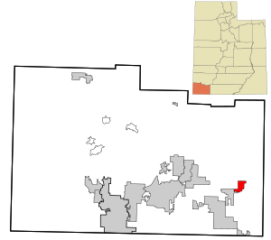
Location in Washington County and the state of Utah
|
|
| Country | United States |
| State | Utah |
| County | Washington |
| Settled | 1862 |
| Named for | Springs |
| Area | |
| • Total | 4.62 sq mi (11.96 km2) |
| • Land | 4.62 sq mi (11.96 km2) |
| • Water | 0.00 sq mi (0.00 km2) |
| Elevation | 3,855 ft (1,175 m) |
| Population
(2010)
|
|
| • Total | 529 |
| • Density | 136.24/sq mi (52.60/km2) |
| Time zone | UTC-7 (Mountain (MST)) |
| • Summer (DST) | UTC-6 (MDT) |
| ZIP codes |
84767, 84779
|
| Area code(s) | 435 |
| FIPS code | 49-71840 |
| GNIS feature ID | 2413319 |
Springdale is a small town in Washington County, Utah, located right next to the amazing Zion National Park. In 2010, about 529 people lived here. It was first settled in 1862 by a group of farmers who were looking for a new home after floods in a nearby area called Northrop.
Contents
History of Springdale
In 1992, a big earthquake hit the area. It damaged three houses and also affected the water and power lines in Springdale. The total damage was about $1 million.
A large landslide also happened in the Balanced Rock Hills area of Springdale. It covered part of Utah State Route 9, which is a main road. It took several hours to clear the road. This landslide was huge, about 1,600 feet (488 meters) long and 3,600 feet (1,097 meters) wide. It even had boulders as big as 20 feet (6 meters) across!
Geography of Springdale
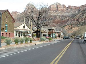
Springdale covers an area of about 4.6 square miles (12.0 square kilometers), and it's all land. The town is nestled in Zion Canyon, surrounded by stunning natural landmarks. To the west, you can see Mount Kinesava, and to the east, there's The Watchman.
The North Fork Virgin River flows right through the town. This river is a very important part of the local landscape. Springdale is located where three different natural areas meet: the Colorado Plateau, the Great Basin, and the Mojave Desert. This makes the area very unique with a mix of different plants and animals.
People and Population in Springdale
Springdale is a small community. In 2010, there were 529 people living in the town. The population density was about 115 people per square mile (44.1 per square kilometer).
Here's a quick look at how the population has changed over the years:
- 1880: 50 people
- 1900: 144 people
- 1920: 204 people
- 1940: 454 people
- 1950: 174 people
- 1970: 182 people
- 1990: 275 people
- 2010: 529 people
- 2019 (estimate): 629 people
In 2010, there were 252 households in Springdale. About 15% of these households had children under 18 living with them. The average age of people in Springdale was about 47.8 years old.
Education in Springdale
The schools in Springdale are part of the Washington County School District. This district manages all the public schools in the county, making sure students in Springdale have access to education.
See also
 In Spanish: Springdale (Utah) para niños
 | Mary Eliza Mahoney |
 | Susie King Taylor |
 | Ida Gray |
 | Eliza Ann Grier |

