Zwickauer Land Rural District facts for kids
Quick facts for kids
Zwickauer Land
|
||
|---|---|---|
|
||
 |
||
| Country | ||
| State | Saxony | |
| Adm. region | Chemnitz | |
| Capital | Werdau | |
| Area | ||
| • Total | 511.09 km2 (197.33 sq mi) | |
| Population
(2001)
|
||
| • Total | 133,741 | |
| • Density | 261.678/km2 (677.743/sq mi) | |
| Time zone | UTC+1 (CET) | |
| • Summer (DST) | UTC+2 (CEST) | |
| Vehicle registration | Z | |
| Website | http://www.zwickauerland.de | |
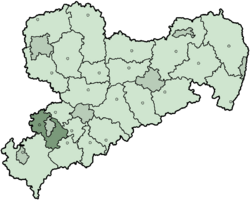
Zwickauer Land was a rural district in the southwest of Saxony, Germany. The city of Zwickau is located in the middle of where the district used to be. It was almost completely surrounded by the district. In July 2008, the city of Zwickau became part of the district's government. This meant it was no longer an independent city.
The rural district was created on 1 August 1994. Its main city, or capital, was Werdau. On January 1, 1999, the district was changed again. Some towns like Cainsdorf, Mosel, Oberrothenbach, and Schlunzig became part of Zwickau. This happened even though the people living there wanted to stay independent.
Geography of Zwickauer Land
The Zwickauer Land district was located in the Ore Mountains. This area is also known as Erzgebirge in German. The two main rivers flowing through the district were the Zwickauer Mulde and the Pleiße.
Symbols: The Coat of Arms
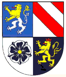
The coat of arms for Zwickauer Land showed symbols from the old areas that made up the district.
- In the top-left corner, you can see a lion. This lion represents the Pleißenland region. It was created in the 12th century by Emperor Frederick I. This symbol stands for the entire district.
- The stripes in the top-right corner come from the coat of arms of the Schönburg family. Their lands were in the northeastern part of the district.
- The black rose in the bottom-left corner is the symbol of the Wildenfels family. This represents the eastern part of the district.
- The lion in the bottom-right corner is the symbol of the Vogt of Weida. It shows the shared history with the nearby Vogtland region.
Towns and Municipalities
Here are the main towns and smaller communities that were part of the Zwickauer Land district:
| Cities | Municipalities |
|---|---|
|
See also
 In Spanish: Distrito de la Comarca de Zwickau para niños
 | James B. Knighten |
 | Azellia White |
 | Willa Brown |


