
Ōkaihau facts for kids
Quick facts for kids
Ōkaihau
|
|
|---|---|
|
Town
|
|

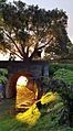
Okaihau Rail Tunnel, built 1926
|
|
| Country | New Zealand |
| Region | Northland Region |
| District | Far North District |
| Ward | Kaikohe/Hokianga |
| Community | Kaikohe-Hokianga |
| Subdivision | Kaikohe |
| Electorates |
|
| Area | |
| • Total | 3.56 km2 (1.37 sq mi) |
| Population
(June 2023)
|
|
| • Total | 370 |
| • Density | 103.9/km2 (269/sq mi) |
Ōkaihau is a small town in the Northland Region of New Zealand's North Island. It is located just north of Kaikohe. State Highway 1 passes through Ōkaihau, making it a busy place.
The name Ōkaihau comes from the Māori language. It means "place of feast of the winds" or "feast of the winds." This name fits well because the town sits on a ridge over 200 meters above sea level. This area was once covered in thick forests. Even today, you can find huge old trees like pūriri nearby.
Ōkaihau is home to two schools: Ōkaihau Primary School and Okaihau College.
Contents
A Glimpse into Ōkaihau's Past
Ōkaihau was a Māori village long ago. Later, settlers arrived on the ridge between Lake Ōmāpere and the Hokianga harbour.
The town became very busy in the early to mid-1900s. This was because it was the northernmost point for the railway line. However, when the railway was removed, the flow of business and tourists slowed down.
Who Lives in Ōkaihau?
Ōkaihau is a rural settlement. It covers about 3.56 square kilometers. As of 2023, about 366 people live here. This is an increase of 42 people since 2018.
The average age of people in Ōkaihau is about 37.4 years old. About 1 in 5 people are under 15 years old.
People in Ōkaihau come from different backgrounds. About 66% are European (Pākehā). About 45% are Māori. Some people identify with more than one ethnicity. Most people speak English, but about 13% also speak the Māori language.
Getting Around: Ōkaihau's Transport History

On October 29, 1923, a branch line railway opened in Ōkaihau. It connected to the main North Auckland Line at Otiria. There were plans to extend the line further north to the Hokianga Harbour and Kaitaia. However, building beyond Rangiahua was too expensive. So, the railway line ended in Ōkaihau. This made Ōkaihau New Zealand's northernmost railway station.
Since Ōkaihau was on the main State Highway 1, it became an important place. Goods were moved from trains onto trucks and vice versa.
At first, passenger trains were slow and carried freight too. In 1956, faster railcars took over. These railcars were very popular. They made the railway line more important. But the railcars had mechanical problems and stopped running in 1967.
Freight trains continued until 1976. After that, the line was only for freight. However, less freight was being sent by train. So, the railway line finally closed on November 1, 1987.
Today, you can still see the old Ōkaihau railway station platform. Just north of town, there's also a tunnel. This tunnel was part of the planned extension to Rangiahua. It is New Zealand's northernmost railway tunnel.
There have been ideas to reopen the railway line for forestry. But so far, nothing has happened.
Learning in Ōkaihau: Schools Through Time
Early Schools
The first official record of a school in Ōkaihau is from 1874. Before that, Mr. Joseph Harrison taught school starting around 1870 or 1871. The settlers worked to get timber for a school building. The government then built it and paid the teacher. The first school opened in 1874 with 21 students.
By 1889, the school building was too small. A larger one was built in its place. This bigger school was known as the "Main School." Other schools opened in the area later, including Upper Waihou and Okaihau Public Works School. The Public Works School was needed because many workers came to build the railway line to Kaitaia. It grew to have three teachers.
Secondary Education Begins
Before 1938, there was no secondary school in Ōkaihau. Students had to travel to Auckland or Whangārei to board, or take the train to Kaikohe. The train trip to Kaikohe was very long. Students often didn't get home until late in the evening.
On April 4, 1938, a new combined school opened with 180 students. This school brought together primary and secondary education. The first headmaster was Mr. A. Burnett.
By 1947, the number of students had grown a lot. The combined school became a District High School. It used two extra buildings for both primary and secondary students.
In 1963, a separate building for younger children was built across the road from the Main School.
Okaihau College
In 1973, the High School became Okaihau College. It started teaching students from Year 7 to Year 13. Mr. Laurenson was its first principal.
At the same time, a full primary school was completed around the Infant Block. Mr. N. Thomson became its first headmaster. At the end of 1973, Okaihau College had 263 students. The primary school had 219 students.
Today, Okaihau College has about 306 students.
Okaihau Primary School
Okaihau Primary School teaches children from Years 1 to 6. It has about 136 students.
Ōkaihau Today
Ōkaihau village has several local businesses. You can find a butchery, cafes, a mechanics, two dairies, a Four Square supermarket, and a takeaways shop.
Images for kids
-
Okaihau Rail Tunnel, built 1926
