ʻEwa Beach, Hawaii facts for kids
Quick facts for kids
ʻEwa Beach
ʻEwa
|
|
|---|---|

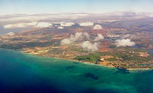
Aerial photo of the ʻEwa Beach area of Oʻahu
|
|

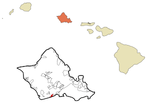
Location in Honolulu County and the state of Hawaiʻi
|
|
| Country | |
| State | |
| County | Honolulu |
| Area | |
| • Total | 1.63 sq mi (4.23 km2) |
| • Land | 1.19 sq mi (3.09 km2) |
| • Water | 0.44 sq mi (1.15 km2) |
| Elevation | 10 ft (3 m) |
| Population
(2020)
|
|
| • Total | 16,415 |
| • Density | 13,782.54/sq mi (5,320.34/km2) |
| Time zone | UTC-10 (Hawaii-Aleutian) |
| ZIP code |
96706
|
| Area code(s) | 808 |
| FIPS code | 15-07450 |
| GNIS feature ID | 0358767 |
ʻEwa Beach is a special community located on the island of Oʻahu in Hawaii. It's part of the City & County of Honolulu. This area sits along the beautiful coast of Māmala Bay.
In 2020, about 16,415 people lived in ʻEwa Beach. The local postal code for this area is 96706.
Contents
History and Meaning of the Name
The name ʻewa means "stray" in the Hawaiian language. This name comes from an old Hawaiian story. The gods Kāne and Kanaloa supposedly threw a stone to mark boundaries. This stone was lost and later found at a place called Pili o Kahe.
People have lived on the ʻEwa Plain for a very long time, since at least the 12th century. Ancient Hawaiians, called kanaka maoli, made the main channel of Puʻuloa (now known as Pearl Harbor) wider. They also built amazing fishponds and farm fields in the area. These old fishponds show how clever and skilled the Native Hawaiians were.
Before it became a town, ʻEwa Beach was a very large sugar plantation. In 1891, when Queen Liliʻuokalani ruled Hawaiʻi, Benjamin Dillingham rented out 11,000 acres of land. W.R. Lowrie became the first manager of the Ewa Sugar Plantation. This plantation was very important to Hawaii's culture, economy, and politics for many years.
When people talk about directions on the south shore of Oʻahu, "Ewa" often means "towards ʻEwa Beach." This is generally west along the coast. Other common direction terms are "mauka" (towards the mountains, north), "makai" (towards the ocean, south), and "Diamond Head" or "Koko Head" (east along the shore).
Where is ʻEwa Beach?
ʻEwa Beach is located at 21°18'56" North and 158°0'26" West. The main road in the area is Fort Weaver Road (State Rte. 76). This road goes north, away from the coast, towards Waipahu. There, it connects to Farrington Highway and the H-1 freeway.
The community covers about 1.9 square miles (4.9 square kilometers). Most of this area is land, but about 0.4 square miles (1.0 square kilometer) is water from the Pacific Ocean.
It's important to know that some nearby communities like Ocean Pointe and ʻEwa Gentry are not part of the ʻEwa Beach community itself. However, they do share the same postal code.
Weather in ʻEwa Beach
ʻEwa Beach has a warm and pleasant climate all year round.
| Climate data for Ewa Beach | |||||||||||||
|---|---|---|---|---|---|---|---|---|---|---|---|---|---|
| Month | Jan | Feb | Mar | Apr | May | Jun | Jul | Aug | Sep | Oct | Nov | Dec | Year |
| Mean daily maximum °F (°C) | 80.5 (26.9) |
80.6 (27.0) |
81.4 (27.4) |
83.0 (28.3) |
84.4 (29.1) |
86.6 (30.3) |
87.6 (30.9) |
88.3 (31.3) |
88.3 (31.3) |
86.7 (30.4) |
84.2 (29.0) |
81.6 (27.6) |
84.4 (29.1) |
| Mean daily minimum °F (°C) | 63.2 (17.3) |
62.7 (17.1) |
64.4 (18.0) |
66.2 (19.0) |
67.4 (19.7) |
69.8 (21.0) |
71.1 (21.7) |
71.4 (21.9) |
70.4 (21.3) |
69.6 (20.9) |
67.9 (19.9) |
65.3 (18.5) |
67.4 (19.7) |
| Average precipitation inches (mm) | 3.1 (79) |
2.2 (56) |
2.2 (56) |
1.2 (30) |
1.0 (25) |
0.4 (10) |
0.5 (13) |
0.4 (10) |
0.7 (18) |
1.9 (48) |
2.8 (71) |
3.3 (84) |
19.8 (500) |
| Source: Weatherbase | |||||||||||||
Population and People
| Historical population | |||
|---|---|---|---|
| Census | Pop. | %± | |
| 2000 | 14,650 | — | |
| 2010 | 14,955 | 2.1% | |
| 2020 | 16,415 | 9.8% | |
| U.S. Decennial Census | |||
In 2010, there were 14,955 people living in ʻEwa Beach. By 2020, the population grew to 16,415 people.
The community is very diverse, with people from many different backgrounds. Many residents are of Asian or Pacific Islander heritage. About 11% of the population identifies as Hispanic or Latino.
Many households in ʻEwa Beach have children living at home. The average household size is about 4.5 people.
Schools in ʻEwa Beach
The schools in ʻEwa Beach are part of the Hawai'i Department of Education.
Elementary schools located directly in the ʻEwa Beach area include ʻEwa Beach Elementary, Kaʻimiloa Elementary, and Pohakea Elementary. For older students, Ilima Intermediate School and James Campbell High School are also in ʻEwa Beach.
There are also other schools nearby, such as Holomua Elementary, Keone'ula Elementary, and ʻEwa Makai Middle School.
The community also has the Ewa Beach Public & School Library. This library is special because it serves both the students of Campbell High School and the general public. It opened on August 28, 1971.
Little League World Series Success
In 2005, the Little League baseball team from ʻEwa Beach made history! They represented West Oʻahu and the United States in the 2005 Little League World Series.
The team won the championship by beating the team from Curaçao with a score of 7–6. The winning run came in an extra inning, thanks to a "walk-off home run" hit by Michael Memea. This means his home run ended the game immediately and won it for his team!
Famous People from ʻEwa Beach
Several notable people have connections to ʻEwa Beach:
- David Alcos, a politician.
- Bretman Rock (born 1998), a popular social media personality.
- Tua Tagovailoa (born 1998), an American football quarterback who plays for the Miami Dolphins.
- Taulia Tagovailoa (born 2000), an American football quarterback who plays for the Maryland Terrapins.
See also
 In Spanish: Ewa Beach para niños


