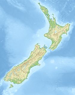
1904 Cape Turnagain earthquake facts for kids
| UTC time | 1904-08-08 22:50:00 |
|---|---|
| ISC event | 16957823 |
| USGS-ANSS | n/a |
| Local date | 9 August 1904 |
| Local time | 10:20 am NZDT (UTC+12) |
| Magnitude | Ms 6.9 Ms 6.8, Mw 7.0–7.2 |
| Depth | 16 km (9.9 mi) |
| Epicenter | 40°24′S 176°39′E / 40.40°S 176.65°E |
| Areas affected | New Zealand |
| Max. intensity | IX (Destructive) |
| Casualties | 1 fatality. |
The 1904 Cape Turnagain earthquake was a strong earthquake that hit New Zealand on August 9, 1904. It happened about 10 kilometers (6 miles) north of Cape Turnagain. The earthquake was very powerful, with a magnitude of about 6.8 to 7.2. People felt the shaking all over the North Island and even in the upper part of the South Island. Many towns within 500 kilometers (310 miles) felt the ground shake a lot. This earthquake caused a lot of damage to the land and to people's homes. Sadly, one person passed away. It was the biggest earthquake in New Zealand since the 1888 North Canterbury earthquake.
Contents
Why Earthquakes Happen in New Zealand
New Zealand is a place where two huge pieces of the Earth's crust, called tectonic plates, meet. These plates are the Australian plate and the Pacific plate.
- In the South Island, these plates mostly slide past each other. This movement happens along a big crack in the Earth called the Alpine Fault.
- In the North Island, one plate slowly slides under the other. This happens at the Kermadec-Tonga subduction zone. This is where the Pacific plate dives beneath the Australian plate. The 1904 Cape Turnagain earthquake happened about 40 kilometers (25 miles) west of this area. It occurred about 16 kilometers (10 miles) deep where the two plates meet.
Finding the Earthquake's Starting Point
When the earthquake first happened, people only guessed where its center was, near Cape Turnagain. Earthquakes are recorded by special machines called seismographs. This earthquake was recorded by machines all over the world.
Scientists used recordings from places like Melbourne, Honolulu, and various sites in New Zealand. By looking at these recordings, experts could confirm that the earthquake's true starting point, called the epicenter, was indeed very close to Cape Turnagain. Their first guess was only about 10 kilometers (6 miles) off!
What Damage Did the Earthquake Cause?
The 1904 Cape Turnagain earthquake caused a lot of damage to the land and buildings.
Landslides and Rockfalls
Many landslides happened over a huge area of more than 3,500 square kilometers (1,350 square miles). This was between Napier and Featherston. Heavy rockfalls were seen along the coastlines of Hawke's Bay and Wairarapa. Cliffs at places like Cape Kidnappers, Bluff Hill, and Cape Turnagain had big rocks fall. Even 215 kilometers (134 miles) away, at Lake Taupo, rocks fell from cliffs.
Many landslides were reported near Herbertville and on the Puketoi Range near Masterton. In Napier, several tons of rock fell from Bluff Hill. Smaller slips kept happening for at least three days after the main earthquake. Near Wimbledon, a very large landslide happened on Sergeant's Hill. A 40–50-meter (130–160-foot) wide section of land slid down, taking hundreds of trees with it.
Liquefaction: When the Ground Acts Like Liquid
Liquefaction also happened in several towns. This is when the ground, usually wet sand or soil, starts to act like a liquid during strong shaking. It can cause buildings to sink or tilt. This was reported in Napier, Porangahau, and Carterton.
One person in Napier saw "large quantities of mud thrown 10 feet into the air in several places." Another report from Gladstone described "innumerable small holes appeared on the flat adjacent, spouting bluish mud and sand like miniature geysers." It also said, "Mud and water shot into the air from a hundred holes in the earth around – like miniature volcanoes."
Fires After the Shaking
Several fires started after the earthquake. Tamumu School in Waipawa burned down. Two houses in Wanstead and Tawataia also caught fire. Other fires started but were put out before they could cause too much damage.
Injuries and Fatalities
The earthquake caused some injuries, but the exact number is not known. Sadly, an elderly man near Eketahuna passed away. It is thought he may have had a stroke or heart attack because of the earthquake.
 | Tommie Smith |
 | Simone Manuel |
 | Shani Davis |
 | Simone Biles |
 | Alice Coachman |


