2010 Cauquenes earthquake facts for kids

The 2010 Cauquenes earthquake was a very powerful earthquake. It happened off the coast of the Maule region of Chile. The earthquake struck near the town of Cauquenes on February 27, 2010. It started at 3:34 AM local time (6:34 UTC). People felt the ground shake for about ten to thirty seconds.
At first, scientists thought the earthquake's strength was between 8.3 and 8.5. This is measured on the Moment magnitude scale. Later, they updated it to an even higher 8.8. This made it the strongest earthquake in Chile since the huge 9.5 1960 Valdivia earthquake. It was also the strongest earthquake anywhere in the world since the 2004 Indian Ocean earthquake.
Contents
What is an Earthquake?
An earthquake happens when two large sections of the Earth's crust, called tectonic plates, suddenly slip past each other. This causes the ground to shake. The place where the earthquake starts deep underground is called the hypocenter. The point directly above it on the Earth's surface is the epicenter.
Where the Earthquake Happened
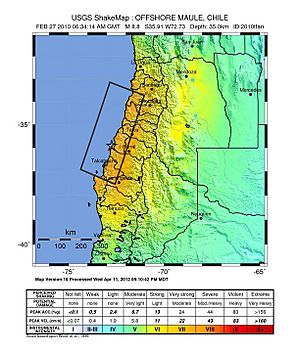
The epicenter of the 2010 Cauquenes earthquake was in the ocean. It was off the coast of the Maule Region in Chile. It was about 8 kilometers (5 miles) west of a town called Curanipe. The city of Concepción was about 115 kilometers (71 miles) north-northeast of the epicenter. Concepción is Chile's second largest city.
Interestingly, this earthquake's epicenter was less than 20 kilometers (12 miles) east of where the 1960 Valdivia earthquake started. Other towns that felt very strong shaking included Arauco, Lota, and Constitución. The shaking was so strong it was rated as "Destructive" on the Modified Mercalli intensity scale.
Impact and Warnings
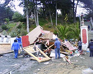
The earthquake was felt far away. People in Chile's capital city, Santiago, felt it. It was also felt in some cities in Argentina. Because of the powerful shaking, Tsunami warnings were sent out to 53 countries around the world. A tsunami is a series of very large ocean waves. They are often caused by underwater earthquakes.
Michelle Bachelet, who was the President of Chile at the time, declared a "state of catastrophe." This means the government could quickly get help and resources to the affected areas. She also confirmed that at least 795 people had died because of the earthquake and the tsunami that followed.
Another Earthquake in March

Chile was hit by another earthquake on March 11, 2010. This second earthquake happened in the coastal town of Pichilemu. Pichilemu is in the Province of Cardenal Caro. It is almost 200 kilometers (124 miles) from Santiago de Chile. This earthquake was not as strong as the first one. It measured 6.9 on the Richter scale.
 | James Van Der Zee |
 | Alma Thomas |
 | Ellis Wilson |
 | Margaret Taylor-Burroughs |


