
2010 Pichilemu earthquake facts for kids

Above: House damaged by the Pichilemu earthquake, in the epicentre town, as seen on 16 April 2011. Below: Pichilemu earthquake shakemap produced by the United States Geological Survey
|
|
 |
|
| UTC time | Doublet earthquake: |
|---|---|
| 2010-03-11 14:39:43 | |
| 2010-03-11 14:55:27 | |
| ISC event | |
| 14554049 | |
| 14400686 | |
| USGS-ANSS | |
| ComCat | |
| ComCat | |
| Local date | 11 March 2010 |
| Local time | |
| 11:39 UTC-3 | |
| 11:55 UTC-3 | |
| Magnitude | |
| 6.9 Mw 6.3 ML |
|
| 7.0 Mw | |
| Depth | 33.1 kilometres (20.6 mi) |
| Epicenter | Pichilemu, Chile 34°18′04″S 72°07′48″W / 34.301°S 72.13°W |
| Areas affected | Chile Argentina |
| Max. intensity | MM X |
| Peak acceleration | 0.086g (Curicó, Maule) |
| Tsunami | Yes |
| Casualties | 1 killed |
On March 11, 2010, two strong earthquakes hit near Pichilemu, a town in the O'Higgins Region of Chile. The first quake had a magnitude of 6.9, and the second was a magnitude 7.0. These earthquakes happened about 40 kilometers southwest of Pichilemu.
After the quakes, the Pacific Tsunami Warning Center issued a tsunami warning. They warned that local tsunamis could happen within 100 kilometers of the earthquake's center, or epicenter. This area was between the cities of San Antonio and Concepción.
At first, some news reports said these quakes were just aftershocks of a bigger earthquake that happened in February 2010. However, experts from the United States Geological Survey (USGS) later said they were separate events. Even though the February earthquake caused stress in the area, the March quakes were different. They were caused by a different type of movement deep within the Earth's plates.
Within six hours of the main quakes, there were 10 smaller earthquakes, called aftershocks. Two of these were strong, with magnitudes of 6 or higher. Seven others had magnitudes between 5 and 6.
Contents
Earthquake During the President's Inauguration
The earthquakes happened just before a very important event in Chile. The new president, Sebastián Piñera, was about to be sworn into office. This ceremony took place at the Chilean congress in Valparaíso.
The shaking was clearly felt at the congress building. The presidents of Bolivia, Paraguay, and Ecuador were also there. Even with the ground shaking, the television cameras showed that the inauguration ceremony continued without stopping.
Damage Caused by the Earthquakes
The earthquakes caused damage in several areas. One pedestrian bridge collapsed over Chile Highway 5, which is north of Rancagua.
The town most affected by the earthquakes was Pichilemu. This was because it was very close to where the quakes started. The quakes damaged the Ross Park and a large part of the Agustín Ross Cultural Centre. Many houses in the areas of Espinillo and Rodeillo were also destroyed.
May 2, 2010 Aftershock
On May 2, 2010, another strong earthquake hit off the coast of Pichilemu. This quake had a magnitude of 6.0. It happened at 10:52 AM local time. The earthquake's center was about 31 kilometers deep.
The USGS reported that this aftershock was about 70 kilometers south-southwest of San Antonio. It was also about 105 kilometers west of Rancagua, the capital city of the region. The quake was felt in Santiago, Chile's capital, which is about 140 kilometers away.
Almost exactly three hours later, a second, smaller quake happened in the same area. It had a magnitude of 4.8. More than 10 aftershocks occurred on May 2 and 3.
Related pages
Images for kids
-
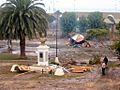
The city of Pichilemu suffered major damage in the 27 February 2010 earthquake and tsunami.
-
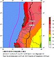
Seismic hazard near the epicentre of the earthquakes.
-
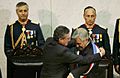
The earthquakes took place just minutes before President Sebastián Piñera was sworn in at the National Congress of Chile.
-

President Piñera's visit to Rancagua on the earthquake day
-
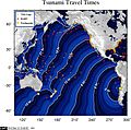
Travel time map of the tsunami triggered by the 11 March 2010 Pichilemu earthquake.
-
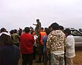
Army personnel at La Cruz Hill, Pichilemu, shortly after the earthquake occurred.
-
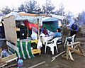
Locals set an improvised camp at the La Cruz Hill in Pichilemu, shortly after the tsunami warning was decreed
-
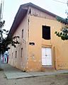
The Pichilemu post-office building was severely damaged by the February and March earthquakes.
-
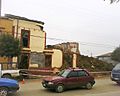
Several buildings in Pichilemu were damaged after the earthquake and its aftershocks.
-

One of the headlines of nationally distributed newspaper El Mercurio of 12 March 2010 was about the Pichilemu earthquakes, along with the oath ceremony of President Piñera on the day before.
-

The New York Times included a headline on their 12 March 2010 main page titled "For Chile, More Aftershocks and An Inauguration", featuring a photograph of presidents Lugo and Correa during one of the earthquakes


See also
 In Spanish: Terremoto de Pichilemu de 2010 para niños
