2012 Kermadec Islands eruption facts for kids
Quick facts for kids 2012 Kermadec Islands eruption |
|
|---|---|

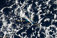
NASA image of Havre Seamount eruption and initial formation of pumice raft
|
|
| Volcano | Havre Seamount |
| Type | Submarine |
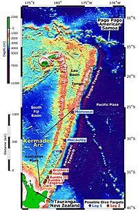
| Location | Kermadec Islands 31°07′13″S 179°58′07″W / 31.12028°S 179.96861°W |
| VEI | 1 |
The 2012 Kermadec Islands eruption was a huge underwater volcano eruption. It happened near the Kermadec Islands in New Zealand. The volcano that erupted was called Havre Seamount. Before this, not many people knew about it.
The eruption created a lot of light, spongy rock called pumice. This pumice floated on the ocean surface. It formed a giant floating island of rock, known as a pumice raft.
At first, this raft covered an area of about 400 square kilometers. But it quickly grew much larger, spreading out to cover between 7,500 and 10,000 square miles (19,000 to 26,000 square kilometers). Within three months, it had spread over an area more than twice the size of New Zealand!
The floating pumice was very thick at the start, up to 3.5 meters (about 11 feet) deep. But after a month, it became thinner, around 0.5 meters (about 1.6 feet) deep.
After three months, the big raft broke up into smaller pieces. Many of these pumice pieces soaked up water and sank to the bottom of the ocean. Some pieces washed ashore in the Tonga islands and on the northern coasts of New Zealand. A year after the eruption, some pumice even reached the eastern coast of Australia.
How the Eruption Happened
Scientists did not know about the Havre Seamount eruption right away. They didn't even know that Havre Seamount was an active underwater volcano.
After the huge pumice raft was found, researchers looked back at old satellite imagery. They also checked past earthquake activity. They wanted to find out exactly when and where the eruption happened.
Scientists who study earthquakes, called seismologists, found a group of earthquakes. These quakes happened on July 18–19, 2012. They ranged from magnitude 3.0 to 4.8. These types of earthquakes often happen when magma (melted rock) moves up inside a volcano.
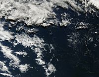
Satellite pictures showed a cloud of ash appearing on July 18, 2012. It lasted for several days. At first, some scientists thought the eruption might have been at another underwater mountain called Monowai Seamount. But they later found out this was not true. The eruption was also not connected to the 2012 eruption of Mount Tongariro in New Zealand.
In 2015, a group of scientists went on a trip to study the Havre Seamount area. They wanted to see how the seafloor had changed. The same group also mapped how the floating pumice moved. It was carried by wind, ocean currents, and swirling water.
The Giant Pumice Raft

Scientists only found out about the eruption when someone saw the huge pumice raft. Maggie de Grauw saw and photographed it on July 31, 2012. She was on a flight from Samoa to New Zealand.
She sent her pictures to Dr. Scott Bryan, a researcher at Queensland University of Technology. They figured out the raft was about 1,000 kilometers (620 miles) north of Auckland. Dr. Bryan then contacted another scientist, Olivier Hyvernaud. He used NASA satellite images to confirm the raft's location.
The New Zealand Defence Force also saw the raft on August 9, 2012. This was several weeks after the eruption. An Orion aircraft spotted it first. Then, the ship HMNZS Canterbury went to the raft and took samples.
The pumice raft was about 300 miles (480 kilometers) long and more than 30 miles (48 kilometers) wide. This means the floating island was bigger than the country of Israel! An officer from the Royal Australian Navy said it was "the weirdest thing [he had] seen in 18 years at sea."
 | Percy Lavon Julian |
 | Katherine Johnson |
 | George Washington Carver |
 | Annie Easley |


