2016 Ecuador earthquake facts for kids
| UTC time | 2016-04-16 23:58:36 |
|---|---|
| ISC event | 608556966 |
| USGS-ANSS | ComCat |
| Local date | April 16, 2016 |
| Local time | 18:58:37 ECT (UTC-5) |
| Magnitude | 7.8 Mw |
| Depth | 20.6 km (12.8 mi) |
| Epicenter | 0°22′16″N 79°56′24″W / 0.371°N 79.940°W |
| Type | Thrust |
| Areas affected | Ecuador, Colombia, Peru |
| Max. intensity | VIII (Severe) |
| Foreshocks | 4.8 Mw |
| Aftershocks | 1,034 as of 07:50 ECT (12:50 UTC) April 28 |
| Casualties | 668 killed, 8 missing and 6,274 severely injured |
On April 16, 2016, a very strong earthquake hit Ecuador. It happened at 6:58 PM local time and had a magnitude of 7.8. The earthquake's center was near the town of Muisne, about 17 miles away. Even the capital city, Quito, which is 110 miles away, felt the shaking.
This powerful earthquake caused a lot of damage. Many buildings and roads were destroyed. Even structures far from where the earthquake started fell down. Sadly, 668 people died, and over 6,200 people were badly hurt.
After the earthquake, President Rafael Correa announced a state of emergency. This meant the government could quickly get help and resources to the affected areas.
Contents
What Happened During the Earthquake?
The 2016 Ecuador earthquake was a major event. It happened because of a thrust fault. This is when one part of the Earth's crust pushes over another part. The earthquake was quite shallow, only about 20.6 kilometers (12.8 miles) deep. Shallow earthquakes often cause more damage because the energy is closer to the surface.
Where Was the Shaking Felt?
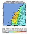
The main shaking was felt most strongly in Ecuador. But people in nearby countries like Colombia and Peru also felt the ground move. The earthquake was so strong that it was rated as Severe on the Modified Mercalli Intensity scale.
Aftershocks and Their Impact
After the main earthquake, there were many smaller earthquakes called aftershocks. These aftershocks continued for days and weeks. By April 28, 2016, there had been over 1,000 aftershocks. These smaller quakes can cause more damage to buildings already weakened by the main earthquake.
The Aftermath and Recovery Efforts
The earthquake left many people without homes and basic services. Rescue teams worked hard to find survivors and help the injured. Countries around the world sent aid to Ecuador. This included food, water, medical supplies, and rescue workers.
How Ecuador Responded
The government of Ecuador quickly started helping people. The state of emergency allowed them to use national resources to help with rescue and recovery. Many people lost everything, and rebuilding homes and communities took a long time.
Images for kids
-
USGS shakemap showing how strong the shaking was.
See also
 In Spanish: Terremoto de Ecuador de 2016 para niños


