
2023–2024 Sundhnúkur eruptions facts for kids
Quick facts for kids 2023–2024 Sundhnúkur eruptions |
|
|---|---|

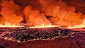
The 2023 eruption photographed by the Icelandic Meteorological Office on 18 December
|
|
| Volcano | Eldvörp–Svartsengi |
| Type | Fissure eruption |
| Location | Reykjanes Peninsula, Iceland 63°52′45″N 22°23′14″W / 63.87917°N 22.38722°W |
| Impact | Earthquakes, ground subsidence, lava fountains, lava flows; town of Grindavík heavily damaged and evacuated; damage to regional infrastructure; 1 presumed dead from ground cracking |
The 2023–2024 Sundhnúkur eruptions are a series of volcanic eruptions happening right now in Iceland. They are near the town of Grindavík on the Reykjanes Peninsula. Since December 2023, there have been five eruptions, all after many strong earthquakes. Even though these events are local, they have caused big problems for the western part of the peninsula, especially for Grindavík.
These eruptions started after a lot of earthquakes in the Eldvörp–Svartsengi volcano area. This started on October 24, 2023, because hot rock (called magma) was pushing up from underground. The earthquakes got much stronger on November 10, 2023. About 20,000 tremors were recorded, with the biggest one being over magnitude 5.3. Because of this, people in Grindavík had to leave their homes. The ground also sank in many places, causing a lot of damage.
The first eruption happened on the evening of December 18, 2023. It was at the Sundhnúkur crater row, north of Grindavík. Lava shot out and spread from a crack about 4 kilometers long. This eruption was the biggest in the Reykjanes Peninsula since 2021. But it didn't last long, ending on December 21.
On January 14, 2024, a second crack opened north of Grindavík. A few hours later, a smaller crack appeared very close to the town. Lava from this crack reached and burned three houses. A third eruption started on February 8, 2024, in the same area as the December eruption. Lava flowed over a road and damaged important pipes and wires.
A fourth eruption began on March 16, 2024. This one was even more powerful than the others since 2021. It lasted 54 days, which was longer than the first three eruptions. A fifth eruption started on May 29, 2024.
Contents
Understanding Iceland's Volcanoes

The Reykjanes Peninsula in southwest Iceland is now in a new period of volcanic activity. This comes after about 800 years of quiet. This new activity started with more earthquakes and volcano signs near the mountain Þorbjörn in late 2019. Volcanic periods here usually last 300 to 400 years. Eruptions can happen in six or seven different spots.
Individual eruptions can last 10 to 20 years. The activity might move to new places every 30 to 50 years. Based on history, this current period of eruptions could continue until around the years 2300-2400.
The Eldvörp-Svartsengi volcano area has had 10 times where magma pushed up since December 2019. Seven of these have happened since October 2023. Four of these pushes led to eruptions. Before this, the volcano activity was mostly in the Fagradalsfjall area. Since 2021, there have been seven volcano eruptions on the Reykjanes Peninsula in total.
Iceland often has earthquakes because it sits on the Mid-Atlantic Ridge. This is where the Eurasian and North American tectonic plates meet and pull apart. The earthquakes in 2023 were very large. They were caused by a long line of magma pushing up about 15 kilometers long. This magma was about 800 meters deep. The biggest earthquakes happened under the Sundhnúkur craters. Grindavík is built on old lava flows from the Sundhnúkur craters.
Earthquakes and Ground Changes
| UTC time | 2023-11-10 18:00:56 |
|---|---|
| ISC event | 635891990 |
| USGS-ANSS | ComCat |
| Local date | 10 November 2023 |
| Local time | 18:00:56 GMT (UTC+0) |
| Magnitude | 5.3 Mw (largest tremor) |
| Depth | 2–10 kilometres (1.2–6.2 mi) |
| Epicenter | 63°57′18″N 22°21′29″W / 63.955°N 22.358°W |
| Areas affected | Reykjanes Peninsula, Iceland |
| Max. intensity | VIII (Severe) |
| Casualties | 1 missing |
Shaking in October 2023
From October 24 to 31, 2023, the Reykjanes Peninsula had many earthquakes. This started on October 24 near Þorbjörn and Svartsengi. It was caused by magma pushing up. Over 1,000 earthquakes happened at first. The area had already seen over 700 quakes earlier that month. By October 28, over 7,000 earthquakes were reported. On October 30 alone, about 1,300 more happened.
These earthquakes were mostly 2-3 kilometers deep. They were strongest around the Eldvörp–Svartsengi area, north of Grindavík. Experts watched the activity closely. Signs of magma pushing up near Svartsengi were seen in October. This was shown by GPS data and satellite images. The land was rising quickly near the Blue Lagoon. This was the fifth time the land had risen there since 2020. It meant magma was building up pressure underground.
November 2023 Earthquakes and Ground Cracks

The biggest earthquake, magnitude 5.3, happened on November 10. By then, over 22,000 earthquakes had been recorded since October. Experts thought an eruption was likely. They said it would take days for magma to reach the surface. The magma was pushing up most strongly near the Sundhnúkur crater chain. This is about 3.5 kilometers north of Grindavík.
On November 14, scientists found sulfur dioxide gas in the air. This meant magma was only a few hundred meters below the surface. Even though the number of earthquakes went down after November 10, 700 to 1,000 quakes were still happening daily.
Sensors showed the ground had moved apart by 120 centimeters. Satellite measurements showed a strip of land, 5 by 2 kilometers, had sunk by about 1 meter. This sinking happened from the Sundhnúkur craters to the west side of Grindavík. This helped scientists guess how much magma had pushed up. About 70 million cubic meters of magma pushed up in just 6 hours. The ground continued to sink by about 4 centimeters a day. A large crack opened up through Grindavík. Old maps showed this was an old crack that was opening again. Scientists think this crack formed over 2,000 years ago during the last Sundhnúkur eruption.
On November 16, sensors found sulfur dioxide in a hole in Svartsengi. This is a clear sign of magma being close to the surface. This made experts think the area near Hagafell, north of Grindavík, was at the highest risk. The ground in Svartsengi rose quickly by 3 centimeters from November 18 to 21. This likely meant magma was rising from 5 kilometers deep. An eruption was still expected on November 21. But as earthquakes decreased after November 24, the chance of eruption also went down.
Scientists from the University of Iceland believe that the magma channel, about 2 meters wide, became solid very quickly. About 90% of the magma hardened within 10 to 15 days in November 2023. This was because the Earth's crust is cold. However, some magma near Sundhnúkur remains. This could cause more activity if pressure builds up again. Even though the magma cools fast, the surrounding rock stays hot and weak. This means the area will be unstable for several months. If an eruption happens, it is most likely between Sýlingarfell and Hagafell mountains.
December 2023 Earthquake Activity

On December 1, 2023, the Reykjanes Peninsula saw fewer earthquakes. Most were very small, less than magnitude one. They were mainly between Sýlingarfell and Hagafell. But GPS stations showed the ground was still changing. This meant magma was still building up under Svartsengi. By December 6, experts thought the magma flow into the crack formed on November 10 had stopped. This lowered the risk of an eruption from that crack. However, magma was still gathering under Svartsengi. This meant the volcano was still active, and new magma movements could happen, increasing eruption risk.
Through mid-December, there were still earthquakes, though mostly weak ones. Over 460 earthquakes happened, including a magnitude 2.8 tremor near Hagafell. This showed the ground was still restless. Even though the ground changes slowed down by December 16, the situation was still changing. Scientists kept watching for more volcano activity.
It is likely that the magma under Svartsengi is feeding the 15-kilometer Sundhnúkur crater chain. The ground is still changing near the magma path. This is thought to be because the land is rising at Svartsengi. In early December, GPS data showed the land was higher than before the earthquakes started in October 2023. A volcano expert from the University of Iceland thought this rise was due to tectonic plate movements and magma building up. The big ground shifts on November 10 might have helped magma move from deeper areas to closer to the surface.
After the ground sank in November, the volcano activity at Svartsengi entered a new phase. There was a higher chance of magma moving and causing eruptions. The pattern suggested that events might repeat. Magma would build up under Svartsengi, then feed a crack under Grindavík and towards Sundhnúkur. This is similar to what happened on November 10. In early December, magma was flowing under Svartsengi at a rate like a river. It was believed to be about 5-6 kilometers deep.
The recent earthquake patterns at Svartsengi were like the "Krafla Fires" from 1975. In that series, there were 20 magma movements over ten years, and nine of them led to eruptions. The land usually drops sharply before an eruption, then slowly rises afterward. The sinking in November was caused by magma moving from Svartsengi, under Grindavík, and towards Sundhnúkur.
March 2024 Earthquakes
On March 2, 2024, a series of earthquakes happened. This was seen as magma pushing up but not reaching the surface. Calculations showed the magma was about 3 kilometers long. It was from Stóra-Skógfell to Hagafell. The magma was between 1.2 kilometers and 3.9 kilometers deep. About 1.3 million cubic meters of magma flowed into Sundhnúkur. This was much less than previous events. Magma usually finds the easiest way to the surface. It's not clear why it didn't erupt this time. Maybe there were obstacles, not enough magma, or not enough pressure. This magma movement was different from others. More study is needed to understand it better.
Volcano Eruptions
December 2023 Eruption

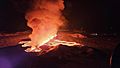
On December 18, 2023, an eruption started around 10:17 PM UTC. Small earthquakes happened about an hour before. The eruption was near Hagafell, about 4 kilometers northeast of Grindavík. It came from a crack about 3.5 kilometers long. Lava flowed out at a rate of 100-200 cubic meters per second. The crack followed the line of old Sundhnúkur craters.
An official said the eruption happened quickly and was "quite a large event." It was the biggest eruption on the Reykjanes Peninsula since 2021. Lava fountains shot up to 100 meters high. The eruption could be seen from Reykjavík, 42 kilometers away.
The Icelandic Coast Guard sent a helicopter to watch the eruption. There were delays at Keflavík International Airport, but it stayed open. The Blue Lagoon spa, which had just reopened, did not take bookings that night. Police raised the danger level. People were warned not to go near the area. By December 19, the smell of smoke and ash was detected 30 kilometers away. People worried about volcanic gases reaching Reykjavík. But the gas levels never became dangerous there. On December 21, experts said no lava was erupting. But they said it was "too early to declare the eruption over." Residents of Grindavík were allowed to return to town. This eruption was the only one that caused no damage to buildings.
January 2024 Eruption

On January 14, 2024, around 7:57 AM UTC, a second eruption began. It was about 400-500 meters north of Grindavík. This followed earthquakes from the Sundhnúksgígar crater. Cracks opened on both sides of the lava barriers. It was thought lava would reach the town within 24 hours. Heavy machines used for barriers were saved. The lava cut off one of the main roads into Grindavík. The first crack was up to 900 meters long.
Around noon, another crack, about 100 meters long, opened very close to the town's outer houses. It set three houses on fire before stopping a few hours later. People in Grindavík were told to evacuate again. The Icelandic Coast Guard sent a helicopter to watch. By January 15, the volcano activity had "decreased considerably."
A volcanologist said this eruption suggested the Reykjanes Peninsula was likely starting a long period of frequent eruptions. This could last for centuries. She called it the New Reykjanes Fires, like a similar event in the 12th century.
February 2024 Eruption

On February 8 at 6:03 AM UTC, the third eruption started north of Sýlingarfell. This followed strong earthquakes 30 minutes before. Lava fountains shot up 50-80 meters high. A 3-kilometer high plume of ash and steam rose into the sky. A 3-kilometer long crack opened in the same area as the December eruption. This was between the Sundhnúkur craters and Stóra-Skógfell hill. It was about 4 kilometers northeast of Grindavík.
Lava flowed quickly east and west. It was far enough from Grindavík. But it badly damaged pipes and wires near the Svartsengi power station. Unlike earlier eruptions, this one produced black ash mixed with steam. Experts think this happened because groundwater boiled and mixed with magma. The volcano activity slowed down later that day.
Experts estimated that about 15 million cubic meters of lava erupted on February 8 alone. This was a flow of about 600 cubic meters per second. About two-thirds of it flowed west into the Svartsengi area. It reached up to 4.5 kilometers from the eruption center.
March-May 2024 Eruption

On March 16 at 8:23 PM UTC, the fourth eruption started between Hagafell and Stóra-Skógfell. Lava fountains were impressive, several dozen meters high. Both the Blue Lagoon and Grindavík were evacuated. A 3-kilometer crack opened, making two lava flows. One flowed west towards the Blue Lagoon and the Svartsengi power plant. It reached Route 43, a road leading into Grindavík. This raised worries about damaging fiber optic cables and causing internet problems. The second lava flow moved south. It reached the eastern protective walls of Grindavík at 1 kilometer per hour.
Experts said this eruption was "significantly wider" than the one in February. A geophysicist called it the "most powerful" in the current series. A state of emergency was declared again. But it was lowered to Alert Phase on April 3. Volcano activity slowed down in the days and weeks after. But it still continued.
At first, lava flowed very fast, 1100-1200 cubic meters per second in the first hour. But this quickly dropped to about 100 cubic meters per second within six to eight hours. By March 17, the new lava field covered almost 6 square kilometers. By March 20, the lava output was about 15 cubic meters per second. It kept decreasing over the next weeks. By April 9, the lava covered 6.14 square kilometers. Only one active crater remained. The land kept rising due to magma flow. In the last two weeks of the eruption, lava flow dropped to 1 cubic meter per second or less.
It seemed magma was coming directly from a deeper chamber. It was bypassing the storage area 4-5 kilometers under Svartsengi. This deeper source, 8-12 kilometers deep, might explain why the eruption lasted so long. In early April, an expert noted the eruption was weakening. Gases were darker, and the land stopped rising. This showed the deeper magma source was now in charge. This was similar to the start of the 2021 Fagradalsfjall eruption. The eruption was officially over on May 9. The lava field grew to about 6.2 square kilometers. The total lava volume was about 34 million cubic meters. This eruption was smaller than the 2021 event. But its volume was three times greater than the December 2023 and February 2024 eruptions.
May 2024 Eruption
On May 29 at 12:45 PM UTC, a fifth eruption began. A crack more than 2.5 kilometers long opened near Sundhnúksgígar. Lava fountains shot up to 50 meters high. Plumes of ash reached 3.5 kilometers high. Grindavík and the Blue Lagoon were evacuated again. Two hours later, the crack was 4 kilometers wide. This eruption followed a week of about 400 earthquakes. About 20 million cubic meters of magma had built up underground. Lava flowing towards Grindavík was stopped by protective barriers. But two of the three roads to the town were cut off.
Wildfires Near the Volcano
During the first weeks of the March-May 2024 eruption, wildfires started on the Reykjanes Peninsula. They were close to where the volcano was erupting. These fires were not as widespread as those during the Fagradalsfjall eruption in 2023. They stayed in a small area. However, very dry soil and light winds increased the risk of the fires spreading. Lava temperatures were very high, 700-800 degrees Celsius.
Firefighters worked hard to control the fires. They used manual labor and tanker trucks. Rescue teams from Grindavík, Árnessýsla, Suðurnes, and Þorbjörn worked together. Emergency crews got the wildfires under control in early April. Most of the flames were put out.
How the Eruptions Affected People
Grindavík Town

Grindavík is mostly empty now because of the volcano. Its residents have left. They are allowed to return for short visits to get their things. Homeowners can also stay in their properties. This is the first time an entire town in Iceland has been evacuated since the Heimaey eruption in 1973. It's hard to say when Grindavík will be safe to live in again. Scientists think the current situation could last for months or even years. The area is currently in an "Alert Phase."
After a 5.2 magnitude earthquake on November 10, a state of emergency was declared. Plans to evacuate Grindavík started. Nearly 4,000 residents, almost 1% of Iceland's population, moved out. The Coast Guard sent a ship for safety. All roads to Grindavík were closed except for emergencies. On November 13, residents could return briefly to get belongings. Boat owners could also move their boats. The government tried to find temporary homes for displaced residents. The ground sinking, cracks, and earthquakes caused a lot of damage to homes and roads. Since November, the town has had many power and hot water outages. News from around the world covered the earthquakes.
During the evacuation, the Icelandic Red Cross helped about 1,700 people. They provided places to stay in three emergency centers. Most people found other places to stay on their own. Everyone in Grindavík got an SMS message from Iceland's emergency service, 112, saying "EVACUATION." Authorities ordered everyone to leave the town.
The Icelandic government planned to help about 700 residents, or 200 families. This included buying up to 210 new apartments. They also offered money to help with housing costs. This support system was estimated to cost a lot of money each month. It was a big effort to help residents find homes. The government also started looking for temporary rental properties from private owners. This was part of a larger housing support program. A website was launched to help Grindavík residents find temporary housing.
Iceland's main banks worked with Finance Iceland to help. They agreed to stop charging interest on housing loans for Grindavík residents for three months. This helped loans up to 50 million ISK. This was to give fair support, including options to delay loan payments.
On February 23, the government passed a law to buy all homes in Grindavík. This was estimated to cost 75 billion ISK. It included taking over all unpaid mortgages. A new company, Þorkatla, is in charge. This aims to help residents who are worried and unsure about their future. Homeowners have until the end of the year to decide if they want to sell to the state. They can also buy back their homes within three years. As of March 27, 2024, 546 residents wanted to sell their homes. Businesses will not be bought, but the government will still help them.
The government also worked to prevent damage to houses from freezing. They wanted to keep Grindavík working and safe. Up to 100 electricians and plumbers made repairs and upgrades. This included fixing power and water connections. Special teams also filled cracks in the ground.
The police lowered the risk level in Grindavík from "Emergency Phase" to "Alert Phase" on November 23, 2023. This was before the December eruption. This meant a sudden eruption was less likely. Residents and businesses could enter the area from 7 AM to 9 PM. They could get valuables and check their properties. But the town was closed to the general public. Safety rules were in place, and the area was still watched. Residents were told to keep records of what they took and to be careful. About 120-150 residents go to work in the town each day. After each eruption, the status was lowered to Alert Phase.
In late February, the police chief allowed almost unlimited access to the town. But he stressed that "residents and employees enter the town at their own risk." He also said Grindavík was not good for children. This was because schools were not working, and roads were damaged. Access is still only for residents, employees, and approved media. Homeowners can stay overnight, but it's not advised.
To improve safety, emergency warning sirens were tested before the March-May eruption. These sirens had not been used since 2000. Now, there are three sirens in Grindavík. More are at the Svartsengi power station and the Blue Lagoon.
The biggest risk in Grindavík now is from the many cracks in the ground. Most formed during the sinking in November. Authorities knew about old cracks before. But many buildings were built over them. These old cracks are now opening again after being quiet for over 2,000 years. Road experts are watching and mapping all cracks. On January 10, a worker filling cracks fell into the largest one. The search was stopped due to danger. This was the first presumed death in Iceland from a volcano since 1973.
The earthquakes damaged many homes. Over 500 reports of damage were made to the Natural Catastrophe Insurance of Iceland. At least 74 homes were too damaged to live in. Three were completely destroyed by lava. The total cost of damages is expected to reach 16 billion ISK. The government has spent almost 100 billion ISK on these disasters.
Blue Lagoon Spa

The Blue Lagoon is now open again. It reopened on April 6. Its opening hours can change based on wind and gas forecasts. It might close temporarily if air pollution from the eruption is bad. The hot springs area has closed and evacuated many times because of earthquakes and eruptions. It hasn't been badly damaged. But lava has covered nearby roads. New roads had to be built. The Blue Lagoon was closed for three weeks after the March-May eruption. This was because it was close to the eruption and toxic gases were released. The closest lava flow is now less than 1 kilometer from the Blue Lagoon. It is protected by a barrier.
The Blue Lagoon closed from November 9 to 16 as a safety step after the earthquakes. Rocks fell on roads. 30 guests left after a magnitude 4.8 earthquake on November 9. The closure also helped reduce stress on staff. All staff got their full salaries. Guests who left got full refunds. The Blue Lagoon confirmed no visible damage to their buildings. They are built to handle earthquakes.
The Blue Lagoon extended its closure five times after the November 2023 evacuation. It reopened on December 17. Staff were trained in evacuation plans. Guests were told about the situation. Despite being closed, staff were seen in the waters, checking them before reopening.
The Blue Lagoon closed again on December 18, 2023. This was after the first eruption started only 2-3 kilometers away. All guests and staff left about one to two hours before the eruption. It reopened on January 6, with all parts working by January 10. But it closed again on January 14 and reopened on January 20. It was safely evacuated at the start of the February 8 eruption. But lava cut off its main access road. On February 16, the Blue Lagoon reopened. A new gravel road was built within the defense barriers. The Blue Lagoon closed temporarily on March 2, expecting an eruption. It reopened two days later when no eruption happened. It closed indefinitely from March 16 due to the current eruption. But it reopened on April 6.
The police chief says keeping the Blue Lagoon open is hard to justify. This is because of the risk of air pollution from the eruption. Managers check with authorities if it's safe to reopen. On March 20, 2024, a staff member was hospitalized. They had symptoms of poisoning from high sulfur dioxide levels. This happened while working at the hot springs. The worker is expected to recover fully. The Blue Lagoon is now rechecking its safety measures. Police inspected the facility.
Svartsengi Power Station

The Svartsengi power station was empty and controlled from far away for months after the November disaster. In 2024, it was evacuated many times due to eruption threats. It had very little damage from the earthquakes. Only inside furniture and outside walls were damaged. There were also cracks in paths. The power station kept making its usual hot and cold water and electricity.
If lava covers the station, about 30,000 people would lose heating and electricity. This is about 8% of Iceland's population. Earth barriers started to be built in November 2023. Their goal is to protect the power station by sending lava flows away.
Before the January eruption, the power station's operator, HS Orka, used a new early-warning system. This system gave an alert more than four hours before the eruption. Since November 2023, holes in the ground have helped predict volcano activity. They detect pressure changes and have reliably signaled upcoming eruptions.
The February 8 eruption produced lava that came close to the power station. It cut off the northern road to the plant. It also destroyed part of the pipe that brings hot water from Svartsengi to several towns. About 20,000 people lost hot water. People were told to use hot water and electricity carefully. Keflavík International Airport and schools were affected. The capital city was not affected. The government declared a state of emergency for the hot water crisis. The Svartsengi power station is key for hot water. Temperatures were as low as -14 °C (6.8 °F). Schools and pools closed on February 9.
The hot water pipe was fixed on February 9, about 30 hours after it broke. Hot water supply was restored. Workers connected undamaged parts of the old pipe to a new underground system. They worked through the night. Workers had been building an underground bypass pipe before the February eruption. This was to protect it from lava. But the new bypass pipe collapsed on February 9. Workers immediately started building a new pipe on top of the fresh lava. Water started flowing through the new pipe on February 12.
Protective Barriers and Roads

Plans for building protective barriers were made long before the recent earthquakes. But construction was put on hold. There was no immediate threat, and it would affect the environment. However, on November 10, due to increasing earthquakes, trucks started bringing materials near the Blue Lagoon and Svartsengi power station. This work stopped quickly due to eruption worries. Construction officially started again on November 13. Workers began building barriers. The barriers were almost done when the December 18 eruption happened. Workers quickly returned to finish the barriers when it was safe.
Protecting the hot water pipe from the plant was very hard. It is above ground on stilts. Before the February eruption, plans were made to bury a new underground bypass pipe. This would shield it from lava. The February 8 eruption destroyed part of the old pipe. It also caused a section of the new underground bypass pipe to collapse. The Svartsengislína powerline was protected with barriers. The same eruption surrounded the structures but caused no damage.
Building protective barriers around Grindavík started on January 2. The project began from the east. It involves building a barrier over 2 kilometers long. The first part aims to be about 4 meters high. The barrier is designed to protect the riskiest areas. On March 21, lava started filling a stone quarry used for barrier materials. But workers can get materials from other places. Recently hardened lava was also used. In late March, authorities decided to make the northeast barriers taller. This was because the lava field was getting thicker. Construction crews will work all the time. By late April 2024, lava started to creep over the same part of the barriers. But it is not an immediate threat.
Another barrier started to be built on May 6, 2024. This is the last project planned by the government for these eruptions. It is inside the older barriers and closer to Grindavík. This new wall will protect against lava overflow. It will be 5 meters high and 0.8-1 kilometer long. It should take 2 to 3 weeks to build. About 30 to 35 people are working on it during the day.
Building barriers for the town of Vogar is also being considered. This is because lava models show a chance of lava flowing north towards Route 41 in the future. Vogar and Route 41 are low risk. But Route 43, closer to the lava, faces a medium risk. On January 14, 2024, lava covered Road 43 south of Svartsengi power station. On February 8 and March 17, the same road north of these places was covered by lava. These events cut off Grindavík from the north. Each time, a new gravel road was built over the cooled lava within days.

Early in the March-May eruption, lava threatened Route 427. It piled up against the eastern barrier of the town. It also moved towards the sea. This put two of the three main roads to Grindavík at risk. Only Route 425 was safe. There was a worry lava would reach the ocean. This could cause small explosions and release toxic gases. An area 500 meters from where lava might enter the sea was very dangerous. But these risks went away when the lava stopped about 300 meters from Route 427. The lava front has not moved since then.
The government added a small property tax to pay for lava barriers. This tax is on the fire insurance value of properties. It will last for three years, starting January 1, 2024. It is expected to raise about 1 billion ISK each year.
Help and Support
After the January 14 eruption, President Guðni Th. Jóhannesson said a "daunting period of upheaval has begun." But he urged people to keep taking "actions that are within our power." He also asked citizens to "stand together and have compassion" for those affected. The Prime Minister, Katrín Jakobsdóttir, called it a "black day for all of Iceland." But she added that "the sun will rise again" and showed support for those affected.
Images for kids
-
The 2023 eruption photographed by the Icelandic Meteorological Office on 18 December
-
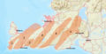
Map of volcanic systems on the Reykjanes Peninsula. Grindavík is at the southern end of the Eldvörp-Svartsengi system (marked here as 2)
-
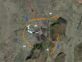
Annotated view of area involved in 2023 seismic disturbances
-
Hagafell (left foreground), viewed from Þorbjörn
-
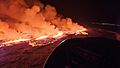
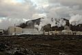
The 18 December 2023 eruption as photographed from a helicopter of the Icelandic Coast Guard. At the right in the background, Grindavík, Iceland, is visible
-

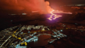
Aerial photograph of the eruption on 14 January 2024
-
A photograph of the eruption on 8 February 2024
-
Aerial photograph of the eruption near Grindavík on 16 March 2024
-
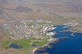
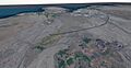
Aerial view of Grindavík before the disaster
-
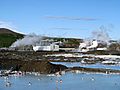
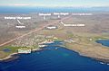
The Blue Lagoon and the Svartsengi power station behind it
-
The Svartsengi power station in 2019
-
A preliminary plan for the protective barriers intended to shield the Blue Lagoon and Svartsengi power station
-
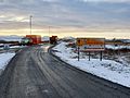
Closure of the road to Grindavík
-
A design of the first phase of the protective barriers around Grindavík
-
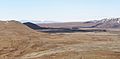
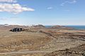
Sundhnúkur craters seen from the south-west


See also
- Geology of Reykjanes Peninsula
- List of earthquakes in 2023
- List of earthquakes in Iceland
- List of volcanic eruptions in Iceland
