Fagradalsfjall facts for kids
Quick facts for kids Fagradalsfjall |
|
|---|---|

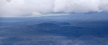
Fagradalsfjall with its main peak Langhóll and Geldingadalir to the right (2012 photo)
|
|
| Highest point | |
| Elevation | Mountain: 385 m (1,263 ft) |
| Geography | |
| Geology | |
| Mountain type | Tuya and fissure system |
| Last eruption | 3–21 August 2022 |
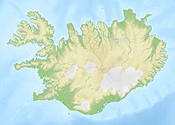
Fagradalsfjall is a cool volcano in Iceland. It's about 40 kilometres (25 mi) from Reykjavík, the capital city. This volcano formed a long, long time ago during the Last Glacial Period, when there was a lot of ice on Earth.
Fagradalsfjall is also the name for a bigger area of volcanoes. This area is about 5 kilometres (3 mi) wide and 16 kilometres (10 mi) long. The highest point here is a peak called Langhóll, which is 385 m (1,263 ft) tall.
For 815 years, there were no volcanic eruptions on the Reykjanes Peninsula. But then, on March 19, 2021, a crack in the ground opened up. This crack, called a fissure vent, appeared in a valley named Geldingadalir. It was just south of Fagradalsfjall mountain.
The 2021 eruption was a "gentle" one. It mostly let out lava that flowed slowly. This eruption kept going on and off until September 18, 2021. Scientists think this eruption might even create a new type of volcano called a shield volcano.
Because it's quite easy to get to from Reykjavík, the volcano became a popular spot. Lots of local people and tourists came to see it. Another eruption, very much like the 2021 one, started on August 3, 2022. It's still considered active, even though no new lava has been seen since August 21, 2022.
Contents
What's in a Name?
The name Fagradalsfjall comes from three Icelandic words.
- Fagur means "fair" or "beautiful."
- Dalur means "dale" or "valley."
- Fjall means "fell" or "mountain."
So, Fagradalsfjall means "beautiful valley mountain." The mountain gets its name from a beautiful valley called Fagridalur, which is to its northwest. The lava field from the 2021 eruption is called Fagradalshraun.
How the Volcano Works
Fagradalsfjall is a volcano located in an area with many cracks, cones, and lava fields. This area is also called Fagradalsfjall. Some scientists believe it's part of a larger volcanic system called Krýsuvík-Trölladyngja. Others think Fagradalsfjall is its own separate volcanic system.
This area is special because it sits on the edge where two huge tectonic plates are pulling apart. These are the Eurasian Plate and the North American Plate. This pulling apart causes the ground to stretch and crack, leading to volcanic activity.
Before the 21st century, the Krýsuvík system had been active in the 1100s. Fagradalsfjall mountain itself was formed thousands of years ago. It had been quiet for 6,342 years until the eruption started in March 2021.
The recent volcanic activity in Fagradalsfjall is part of a bigger period of unrest in the Reykjanes Peninsula. Even though other nearby volcanoes had been more active, this eruption at Fagradalsfjall was a surprise!
The 2021 eruption was the first one seen on this part of the plate boundary. It's different from most volcanoes. Usually, volcanoes are fed by a big magma chamber deep underground. But this eruption might be fed by a long, narrow channel, about 17 km deep, that goes all the way to the Earth's mantle. This means the way the lava flows might depend on this channel.
Keeping People Safe and Welcoming Visitors
The volcano is quite close to towns like Grindavik and Vogar. It's also not far from Keflavík International Airport and the greater Reykjavík area. Because of this, Iceland's emergency services have made plans. These plans help them know what to do if people need to evacuate. They also have plans for gas pollution or lava flows.
A lot of tourists visit the eruption sites. This is a concern for authorities. They worry about tourists who are not prepared. For example, some might not have the right gear for the weather. Others might not listen when areas are closed due to bad weather or new lava flows.
As of the 2022 eruption, there isn't much risk of lava blocking roads or reaching towns. But this could change if the valleys fill up with lava. Or if a new crack opens up somewhere else.
Flying Safely
The eruption site is only about 20 km from Keflavík International Airport. This is Iceland's main international airport. Luckily, this eruption mostly produces lava, not much ash. Volcanic ash can be very dangerous for airplanes. So, this eruption is not seen as a big risk to air traffic.
The aviation authorities have kept the volcano's alert level mostly orange. This means there's an ongoing eruption but with little to no ash. This has meant that flights to and from Keflavik Airport have not been stopped.
The Icelandic Coast Guard flies helicopters to study and watch the volcano. Many helicopter tour companies also fly and land nearby. Small private planes also circle the area to see the eruption. Lots of drones are also flying around the volcano.
Roads and Important Services
One main worry is if lava flows reach important roads. This includes Road 41, which goes to Keflavik and the airport. Also, Road 427, the south coast road, is an important way for people to leave Grindavik if needed.
Another concern is a high-voltage power line to Keflavik. If lava flows north, this line could be cut off. This would affect power to the area. Also, fiber-optic cables that carry internet and phone signals could be cut. This would impact communications and the data center industry in Keflavik. However, where the crack is now (as of August 2022), it's not likely to affect these roads and services.
Within a week of the 2021 eruption, power and fiber-optic lines were set up. These lines went from Grindavik to help the authorities work near the eruption site. Also, 4G cell towers and emergency radio masts were put up. This made sure tourists and authorities had access to communication and emergency services (like calling 112).
Lava Flow Experiments
In July 2021, some interesting experiments were done. Utility companies worked with Iceland's emergency management. They buried different types of utility lines. These included underground electrical cables, fiber-optic cables, water lines, and sewage lines. They had different levels of protection. The goal was to see how lava flowing over them would affect them.
Another experiment involved building large walls called levees. These walls were meant to guide the lava flows. They worked pretty well at controlling slow-moving lava.
Managing Tourism at the Volcano
The Fagradalsfjall volcano site is special because it's close to Iceland's main airport. It's also near popular tourist spots like the Blue Lagoon. The site is only about 60 km from Reykjavík.
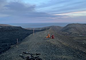
You can get there easily from Grindavik using Road 427. There's limited parking at the start of the hiking trail. The hike to the new eruption site is about 6–8 km each way. It can take 3–6 hours to hike, not counting stops. Many parts of the trail are very steep and rocky. The paths are not always clearly marked because the eruption is so new.
Depending on the wind, dangerous gas can be a risk. Also, lava flows can be unpredictable, and new cracks might open up.
Because it's easy to get to, many locals and tourists have visited the site. About 10,000 people visited the 2022 eruption on its first day! Authorities usually keep the site open. They try to inform people about the risks rather than just banning them.
No one has died directly from the eruption. However, many people have been injured indirectly. This is often because tourists are not prepared. There have been reports of broken ankles, lost travelers, and even hypothermia. The weather in the area can change very quickly.
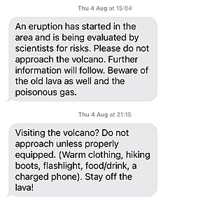
Authorities use special text messages to warn tourists. These messages are sent to mobile phones entering the area. They tell people to be prepared. Volunteers from the Icelandic Association for Search and Rescue and local police are often at the site during busy times. The site has had to be evacuated at least once because lava started flowing too fast. It was also closed for two days in August 2022 due to bad weather. Some tourists who didn't listen to the closures had to be rescued by a local search and rescue team called Þorbjörn.
See also
 In Spanish: Fagradalsfjall para niños
- Volcanism of Iceland
- Geology of Reykjanes Peninsula
- Geography of Iceland
- Geology of Iceland
- List of volcanic eruptions on Iceland
 | Selma Burke |
 | Pauline Powell Burns |
 | Frederick J. Brown |
 | Robert Blackburn |


