Volcanism of Iceland facts for kids
- The volcano system in Iceland that started activity on August 17, 2014, and ended on February 27, 2015, is Bárðarbunga.
- The volcano in Iceland that erupted in May 2011 is Grímsvötn.
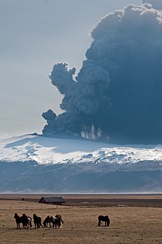
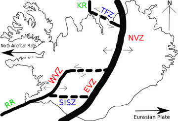
Iceland has lots of volcanoes! This is because it sits on the Mid-Atlantic Ridge. This is where two huge tectonic plates are pulling apart. Iceland is also located over a hot spot, which is like a super hot spot deep inside the Earth.
Nearly 30 volcanoes have erupted in Iceland since the last ice age. One of these, Eldgjá, caused the biggest lava eruption in human history!
Contents
Iceland's Volcanic Zones and Systems
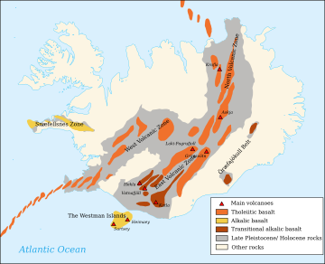
Most of Iceland's recent volcanic activity happens in a special area called the Neovolcanic Zone. This zone includes several volcanic belts. These are like long lines of volcanoes and cracks in the Earth.
Some of these belts are the Reykjanes Volcanic Belt (RVB) and the East Volcanic Zone (EVZ). There are also two smaller volcanic zones. Outside the main island, there are underwater ridges that are part of the Mid-Atlantic Ridge.
Iceland has about 30 active volcanic systems. Each system includes cracks in the Earth and often a main volcano. This main volcano is usually a stratovolcano (cone-shaped) or a shield volcano (flat and wide). Underneath these volcanoes, there's a magma chamber filled with molten rock.
Since people first settled in Iceland in AD 874, 13 of these volcanic systems have erupted. The most active one is Grímsvötn. Over the last 500 years, Iceland's volcanoes have produced a third of all the lava in the world!
Major Volcanic Eruptions in Iceland
Iceland has seen many powerful eruptions. Here are some of the most important ones.
Hekla: The Gate of Hell
Hekla volcano has erupted over 20 times in recorded history. In the Middle Ages, people in Europe called it the "Gate of Hell." This scary name stuck around for a long time!
Laki/Skaftáreldar: 1783-84 Disaster
The deadliest eruption in Iceland's history was the Skaftáreldar (fires of Skaftá) in 1783. This eruption happened from cracks called Lakagígar (craters of Laki). These craters are part of a bigger volcanic system connected to Grímsvötn.
About a quarter of Iceland's population died because of this eruption. Most people didn't die from the lava itself. Instead, they died from the effects of the ash and poisonous gases. These caused climate changes and made livestock sick in the years that followed. This eruption is thought to have produced the most lava from a single eruption in recorded history.
Eldfell: 1973 Island Eruption
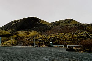
Eldfell is a volcanic cone that formed during an eruption in January 1973. It appeared on the east side of Heimaey island. The eruption started without any warning!
About 5,300 people living on the island had to leave quickly on fishing boats. People even sprayed seawater on the lava to slow it down and protect the harbor. One person died, and many homes were destroyed.
Eyjafjallajökull: 2010 Air Travel Chaos
The eruption under Eyjafjallajökull in April 2010 caused huge problems for air travel. For six days, planes couldn't fly across western and northern Europe. About 20 countries closed their airspace, affecting around 10 million travelers.
This eruption was very explosive, with a VEI of 4. This was the biggest eruption known from Eyjafjallajökull. Sometimes, eruptions from Eyjafjallajökull are followed by eruptions from the larger Katla. But after the 2010 eruption, Katla stayed quiet.
Grímsvötn: 2011 Ash Cloud
In May 2011, Grímsvötn erupted under the Vatnajökull glacier. It sent thousands of tons of ash into the sky in just a few days. This made people worry about another air travel problem like in 2010.
Hóluhraun: Iceland's Largest Eruption in 230 Years (2014–2015)
Bárðarbunga is a stratovolcano about 2,000 meters (6,560 feet) high. It's in central Iceland, near the northern edge of Vatnajökull. This makes it the second-highest mountain in Iceland.
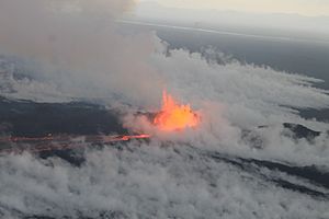
Hóluhraun is an older lava field about 50 km northeast of Bárðarbunga. The eruption started here on August 17, 2014, and lasted for 180 days. This was Iceland's largest eruption in 230 years!
After many earthquakes, lava fountains began erupting in Holuhraun. The lava flowed very fast, between 250 and 350 cubic meters per second. It came from a crack (called a dyke) over 40 km long. A huge bowl, over 100 square kilometers wide and up to 65 meters deep, formed in the ice.
This eruption didn't produce much ash. The main concern was the large clouds of sulphur dioxide (SO2) gas. This gas made breathing difficult in Iceland, depending on the wind. The volcanic cloud even reached Western Europe in September 2014.
Fagradalsfjall: 2021 Eruption
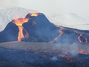
After three weeks of many small earthquakes, a crack opened up near Fagradalsfjall. This mountain is on the Reykjanes Peninsula. On March 19, 2021, an Icelandic Coast Guard helicopter first spotted lava flowing from a 200-meter crack. This happened in the Geldingadalur area near Grindavík. Within hours, the crack grew to 500 meters long!
Litli-Hrútur: 2023 Eruption
On July 10, 2023, at 4:40 PM UTC, another crack eruption began. This one was next to the top of Litli-Hrútur mountain.
Types of Lava Fields in Iceland
When lava flows, it can create different types of surfaces.
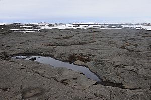
One type is called pāhoehoe. In Icelandic, it's called helluhraun (pronounced: hell-uh-hroyn). This lava flows smoothly and creates flat surfaces that are easy to walk on.
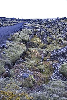
Another type is called ʻaʻā. In Icelandic, it's called apalhraun (pronounced: ah-pal-hroyn). This lava is thicker and forms a rough, broken, and sharp surface. Walking across an ʻaʻā flow is difficult and dangerous because you can easily trip or hurt your leg.
See also
 In Spanish: Vulcanismo en Islandia para niños
- Geography of Iceland
- Geology of Iceland
- List of volcanoes in Iceland
- List of volcanic eruptions in Iceland
- Geothermal power in Iceland
- Geology of Reykjanes Peninsula
- Surtsey
- Lists of volcanoes
 | Kyle Baker |
 | Joseph Yoakum |
 | Laura Wheeler Waring |
 | Henry Ossawa Tanner |


