
Eyjafjallajökull facts for kids
Quick facts for kids Eyjafjallajökull |
|
|---|---|
| Guðnasteinn Hámundur |
|

Gígjökull, Eyjafjallajökull's largest outlet glacier, covered in volcanic ash
|
|
| Highest point | |
| Elevation | Mountain: 1,651 m (5,417 ft) Glacier: 1,666 m (5,466 ft) |
| Geography | |

Eyjafjallajökull
Location in Iceland
|
|
| Location | Suðurland, Iceland |
| Parent range | N/A |
| Geology | |
| Mountain type | Stratovolcano |
| Volcanic arc/belt | East Volcanic Zone |
| Last eruption | March to June 2010 |

Eyjafjallajökull (meaning 'glacier of the mountains of the islands'), sometimes called E15, is one of Iceland's smaller ice caps. It is located north of Skógar and west of Mýrdalsjökull. This ice cap covers a volcano with a peak that is 1651 meters (5417 ft) high. The volcano has erupted many times since the last Ice Age. Its most recent eruption was in 2010. Even though it was a relatively small eruption, it caused huge problems for air travel across northern and western Europe for a week.
Contents
What is Eyjafjallajökull?
Eyjafjallajökull is a volcano completely covered by an ice cap. The ice cap is about 80 square kilometers (31 sq mi) in size. It feeds many outlet glaciers, which are like rivers of ice. The main glaciers are Gígjökull and Steinholtsjökull to the north.
In 1967, a huge landslide happened on the Steinholtsjökull glacier. About 15 million cubic meters (530 million cu ft) of material hit the glacier. This caused a massive amount of air, ice, and water to rush out from under the glacier into the lagoon below.
The volcano itself is a stratovolcano. It stands 1651 meters (5417 ft) tall at its highest point. It has a crater that is 3 to 4 kilometers (1.9 to 2.5 mi) wide. This crater is open towards the north. The rim of the crater has three main peaks: Guðnasteinn (1500 m or 4900 ft), Hámundur (1651 m or 5417 ft), and Goðasteinn (1497 m or 4911 ft).
The southern side of the mountain was once Iceland's coastline. Over thousands of years, the sea has moved back about 5 kilometers (3.1 mi). The old coastline is now made of steep cliffs with many waterfalls. The most famous one is Skógafoss. When winds are strong, water from smaller falls can even be blown up the mountain. The flat land between the mountain and the current coast is called Eyjafjöll. It is about 2 to 5 kilometers (1.2 to 3.1 mi) wide.
Meaning of the Name

The name "Eyjafjallajökull" means "glacier of Eyjafjöll." Eyjafjöll is the name for the southern part of the volcano and the small mountains at its base. The word "jökull" means "glacier" or "ice cap" in Icelandic.
How the Volcano Works

Eyjafjallajökull is a stratovolcano. Its vents, where lava comes out, run from east to west. It is made up of basalt to andesite lavas. Most of its past eruptions have been explosive. However, cracks called fissure vents can also open on its sides, mostly on the west.
The volcano gets its molten rock (magma) from a magma chamber deep under the mountain. This magma comes from the tectonic plates pulling apart at the Mid-Atlantic Ridge. Eyjafjallajökull is part of a chain of volcanoes across Iceland. Its closest active neighbors are Katla to the northeast and Eldfell on Heimaey to the southwest.
Scientists think Eyjafjallajökull and Katla are connected underground. This is because eruptions of Eyjafjallajökull have often been followed by eruptions of Katla.

Past Eruptions
Eyjafjallajökull has erupted in the years 920, 1612, 1821, and 2010. The eruption in 920 was from a long crack (fissure). The eruptions in 1612 and 1821 were smaller eruptions from the top of the volcano.
The 1821 to 1823 Eruptions
A smaller eruption in 1821 caused some damage. The ash from this eruption had a lot of fluoride. Too much fluoride can harm the bones of animals and people. The eruption also caused small and medium glacier runs, which are floods from melting ice, in nearby rivers like Markarfljót and Holtsá.
The eruption started on December 19 and 20, 1821, with several explosive bursts. It continued for the next few days. People reported heavy ash fall around the volcano, especially to the south and west.
The eruptions became calmer until June 1822. From late June to early August 1822, more explosive eruptions happened. Ash clouds went very high into the sky. Ash fell far away, even in northern Iceland and near Reykjavík.
From August to December 1822, things seemed quieter. However, farmers believed their cattle and sheep died because of poisoning from this eruption's ash. Modern science shows this was likely fluoride poisoning. Some small glacier floods happened in the Holtsá river. A bigger one flooded the plains near the Markarfljót river.
In 1823, some people hiked up Eyjafjallajökull to look at the craters. They found a new crack (fissure vent) near the top caldera, west of Guðnasteinn. In early 1823, the nearby volcano Katla erupted. At the same time, steam was seen rising from the top of Eyjafjallajökull.
The ash from Eyjafjallajökull's 1821 eruptions is found all over southern Iceland. It is dark gray, fine-grained, and contains about 28–40% silicon dioxide.
The 2010 Eruptions

On February 26, 2010, scientists noticed unusual shaking and fast swelling of the Earth's crust. This showed that magma was moving into the volcano's magma chamber. The pressure from this magma caused the ground to move a lot at a nearby farm. In March 2010, almost 3,000 small earthquakes were felt near the volcano. They were all about 7 to 10 kilometers (4.3 to 6.2 mi) deep. The shaking continued to increase, with nearly 3,000 earthquakes measured from March 3–5.
The eruption is thought to have started on March 20, 2010. It was about 8 kilometers (5.0 mi) east of the volcano's main crater. This first eruption happened on Fimmvörðuháls, a high pass between Eyjafjallajökull and Mýrdalsjökull. It was a 300-meter-long crack (fissure vent) and did not happen under the glacier. This eruption was smaller than some geologists expected. It had 15 lava fountains reaching up to 185 meters (607 ft) high. The crack opened on the north side of Fimmvörðuháls, right across a popular hiking trail.


On April 14, 2010, Eyjafjallajökull started erupting again after a short break. This time, it erupted from the main crater in the center of the glacier. This caused jökulhlaup (meltwater floods) to rush down nearby rivers. About 800 people had to leave their homes. This eruption was explosive because meltwater got into the volcanic vent. It was estimated to be 10 to 20 times larger than the first eruption.
This second eruption sent volcanic ash several kilometers into the air. This led to huge problems for air travel in northwest Europe for six days, from April 15 to 21, 2010. This affected over 20 countries and as many as 10 million air travelers. The volcano erupted again in May 2010, causing more airspace closures over Europe. The eruptions also created electrical storms (volcanic lightning).
By August 2010, Eyjafjallajökull was considered to be sleeping (dormant). Sensors have been put around Eyjafjallajökull to watch for future eruptions. In total, the 2010 eruptions produced about 0.27 cubic kilometers (270,000,000 cubic meters) of ash. This ash fell over central southern Iceland and parts of Europe. Areas close to the volcano had an ash layer several centimeters thick. The ash also made nearby glaciers less reflective, causing them to absorb more heat.
Connection to Katla Volcano

Eyjafjallajökull is about 25 kilometers (16 mi) west of another volcano under a glacier, Katla. Katla is under the Mýrdalsjökull ice cap. Katla is much more active and known for its powerful eruptions under the ice. It also has a very large magma chamber.
Historically, every time Eyjafjallajökull has erupted (in 920, 1612, and 1821–1823), an eruption of Katla has followed. Katla did not show any unusual activity during Eyjafjallajökull's 2010 eruptions. However, geologists have been worried about Katla's general instability since 1999. Some scientists in Iceland believe that the Eyjafjallajökull eruption might trigger an eruption of Katla. A Katla eruption would cause major floods from melting glacial ice and send up huge clouds of ash.
On April 20, 2010, Iceland's President, Ólafur Grímsson, said that "the time for Katla to erupt is coming close." He added that Iceland was prepared and that other countries should also plan for a possible Katla eruption.
Volcanologists continue to watch Katla closely. They know that if Katla erupts after Eyjafjallajökull, it has usually happened within months. The Icelandic Meteorological Office updates its website with reports of earthquakes at both volcanoes. On July 8, 2011, a jökulhlaup (glacial flood) from Katla destroyed a bridge on the Ring Road. It also caused cracks to appear on Katla's glacier.
Special Postage Stamps
In 2010, Icelandic Post released three special stamps about the Eyjafjallajökull volcano eruption. All these stamps actually contain real volcanic ash that fell on April 17, 2010.
Images for kids
-
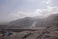
Gígjökull, Eyjafjallajökull's largest outlet glacier, covered in volcanic ash.
Related pages
See also
 In Spanish: Eyjafjallajökull (glaciar) para niños
- List of glaciers of Iceland
- List of waterfalls of Iceland
- Ragnar Th. Sigurdsson, who photographed the 2010 eruption
- Volcanism of Iceland
- List of volcanic eruptions in Iceland
- List of volcanoes in Iceland
- 2010 eruptions of Eyjafjallajökull
