
Hekla facts for kids
Quick facts for kids Hekla |
|
|---|---|

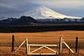
Hekla and Þjórsá
|
|
| Highest point | |
| Elevation | 1,488 m (4,882 ft) |
| Naming | |
| English translation | Hooded |
| Language of name | Icelandic |
| Geography | |

Hekla
Location in Iceland
|
|
| Geology | |
| Mountain type | Active fissure stratovolcano |
| Last eruption | February to March 2000 |
| Climbing | |
| First ascent | Eggert Ólafsson, Bjarni Pálsson, 20 June 1750 |
Hekla (Icelandic pronunciation: [ˈhɛhkla]), also spelled Hecla, is a very active volcano in southern Iceland. It stands about 1,491 meters (4,892 feet) tall. Hekla is one of Iceland's busiest volcanoes. It has erupted more than 20 times since the year 1210. Long ago, during the Middle Ages, people in Iceland and across Europe called Hekla the "Gateway to Hell".
Hekla's eruptions are often big and start with a bang. They have covered much of Iceland with tephra, which is a mix of ash and rock. Scientists use these layers of tephra to figure out when other volcanoes in Iceland erupted. About 10% of all the tephra made in Iceland over the last 1,000 years came from Hekla. That's about 5 cubic kilometers (1.2 cubic miles) of material! Hekla has also produced a huge amount of lava, around 8 cubic kilometers (1.9 cubic miles), making it one of the world's biggest lava producers in the last thousand years.
Contents
What's in a Name? The Meaning of Hekla
In the Icelandic language, the word Hekla means a short hooded cloak. This name might come from the fact that the volcano's top is often covered in clouds, like a hood. An old Latin book even called the mountain Mons Casule, which also means "Hooded Mountain".
Hekla's Scary Stories and Legends
_Detail_from_map_of_Iceland_1585.jpg)

After a big eruption in 1104, scary stories about Hekla began to spread across Europe. Monks, especially the Cistercians, helped share these tales. They said Hekla was the actual entrance to Hell. One monk, Herbert of Clairvaux, wrote in 1180 that the famous fiery pit in Sicily was tiny compared to Hekla's huge fire.
Around 1120, a poem about the travels of Saint Brendan even said that Hekla was where Judas was imprisoned. In 1341, during another eruption, people reported seeing large and small birds flying in the volcano's fire. They believed these were souls. Even in the 16th century, people like Caspar Peucer wrote that the "Gates of Hell" were in Hekla. This belief lasted until the 1800s. Today, there's still a legend that witches gather on Hekla during Easter.
Where is Hekla? Its Location and Shape
Hekla is part of a long line of volcanoes, about 40 kilometers (25 miles) long. The most active part of this line is a crack in the ground called Heklugjá (Icelandic pronunciation: [ˈhɛhklʏˌcauː]), which is about 5.5 kilometers (3.4 miles) long. This crack is considered part of Hekla itself. Hekla looks a bit like an upside-down boat. The "keel" of the boat is a series of craters, and usually, two of these are the most active.
How Hekla Works: The Science of the Volcano

Hekla is a special type of volcano. It's a mix between a fissure vent (a long crack that erupts) and a stratovolcano (a cone-shaped volcano built from layers of lava and ash). It sits where two major geological zones meet in Iceland. Hekla's unique shape is rare, found in only a few other volcanoes worldwide.
During big eruptions, the 5.5-kilometer (3.4-mile) long Heklugjá crack opens up completely. The magma (melted rock) that feeds Hekla comes from a chamber deep underground. This chamber is estimated to be about 4 kilometers (2.5 miles) below the surface.
Many eruptions start with thick, explosive rhyolite, dacite, or andesite rock. These create a lot of tephra and can cause dangerous pyroclastic flows (fast-moving clouds of hot gas and ash). Later, or in other eruptions, thinner basalt magma flows out, forming large lava fields.
The tephra from Hekla's eruptions has a lot of fluorine. This chemical is poisonous to animals. So, when ash falls on grass, it can make livestock sick if they eat it. Hekla's lava is also special because it has more silica than other nearby lavas. It's the only volcano in Iceland that produces a certain type of lava called calc-alkaline lava.
When Hekla is not erupting, it's often covered in snow and small glaciers. It's also unusual because there are very few earthquakes around it until just before an eruption. Earthquakes usually start only 30 to 80 minutes before Hekla erupts. Scientists watch Hekla very closely today. They use special tools to measure changes in the ground and seismic activity. Earthquakes near the volcano are usually small when it's quiet, but they can reach a magnitude of 3 when it's erupting.
Hekla's Eruption History: A Fiery Past

The first eruption of Hekla that we know about happened in 1104. Since then, there have been between 20 and 30 major eruptions. Sometimes, the mountain stays active for years with only short breaks. Hekla's eruptions are hard to predict because they can be very different. Sometimes, there are only a few hours of warning earthquakes. Some eruptions are very short, lasting only a week or two. Others can go on for months or even years, like the 1947 eruption which lasted over a year. Generally, the longer Hekla sleeps, the bigger and more powerful its next eruption will be. The most recent eruption was on February 26, 2000.
Ancient Eruptions: Hekla's Deep History

One of the biggest eruptions in Iceland's recent geological past was the Hekla 3 (or H3) eruption around 1000 BC. This eruption blasted about 7.3 cubic kilometers (1.75 cubic miles) of volcanic rock into the air. It was so big that it cooled temperatures in the northern parts of the world for a few years. Scientists have found traces of this eruption in peat bogs in Scotland. In Ireland, studies of tree rings from that time show that trees barely grew for a whole decade.
Hekla 3, 4, and 5 produced huge amounts of ash and tephra. These layers covered 80% of Iceland and are used as important markers in soil in other parts of Europe. Over the last 7,000 years, one-third of all the volcanic ash found in Scandinavia, Germany, Ireland, and the United Kingdom came from Hekla.
Eruptions from 1104 to 1878
- 1104 (H1)

Hekla had been quiet for at least 250 years before it exploded in 1104. This powerful eruption covered over half of Iceland (55,000 square kilometers or 21,000 square miles) with a huge amount of tephra. Farms as far as 70 kilometers (43 miles) away were abandoned because of the damage. This eruption made Hekla famous across Europe.
- 1158
A strong eruption happened on January 19, 1158. It produced a lot of lava and tephra.
- 1300–1301

This eruption started on July 11 and lasted for a year. It was Hekla's second-largest tephra eruption since people settled in Iceland. It covered 30,000 square kilometers (12,000 square miles) of land with tephra. Over 500 people died that winter because of the damage to their homes and farms.
- 1341
A smaller eruption on May 19 deposited tephra to the west and southwest of Hekla. This caused many cattle to die, likely from fluorine poisoning from the ash.
- 1389
In late 1389, Hekla erupted again. It started with a big blast of tephra. Later, the eruption crack moved outside the main mountain into nearby woods. A large lava flow destroyed two farms and created a new lava field.
- 1510

The 1510 eruption was very violent. It threw volcanic bombs (pieces of hot rock) as far as 40 kilometers (25 miles) away. A man in Landsveit was killed.
- 1693
This eruption, starting on January 13, was one of Hekla's most destructive. It lasted over 7 months. It produced a lot of tephra very quickly, causing mudslides (lahars) and even small tsunamis. The tephra damaged farms and forests to the northwest. Fine ash from this eruption reached Norway. Many animals, including fish, birds, and farm animals, died.
- 1766–1768
The 1766 eruption was huge. It produced the second-largest lava flow and third-largest tephra volume of any Icelandic volcano since people lived there. The eruption lasted for over two years. Lava bombs up to 0.5 meters (1.6 feet) wide were thrown 15-20 kilometers (9-12 miles) away. The sudden melting of snow and ice on Hekla's slopes caused flooding.
- 1845–1846

Hekla had been quiet for over 60 years before it erupted suddenly on September 2, 1845. People in the Orkney Islands (far away!) found volcanic dust on the ground. The eruption started with loud groaning sounds, then two large openings formed on the sides of the volcano, pouring out lava. The top of the mountain was covered in clouds of steam and ash. Rivers nearby became so hot that fish died. Sheep ran away in fear, and some were burned.
New openings formed later, releasing more lava that flowed for over 20 miles (32 km). This lava was 40-50 feet (12-15 meters) deep and nearly a mile (1.6 km) wide in some places. The eruption continued until April 1846. The ash poisoned grass, causing many cattle to die from a disease. The ice and snow on the mountain melted completely. Large pieces of pumice (lightweight volcanic rock) weighing almost half a ton were thrown several miles away.
- 1878

A smaller eruption happened between February and April 1878, about 10 kilometers (6 miles) east of Hekla. It produced lava from two cracks, covering a large area.
Eruptions from 1913 to 1991
- 1913
.jpg)
Another small eruption occurred in 1913, also east of Hekla. It created large cracks that produced lava flows.
- 1947–1948
This eruption started on March 29, 1947, and lasted until April 21, 1948. It was one of Hekla's biggest lava eruptions in the 20th century. Before this, Hekla had been quiet for over 100 years, the longest break since 1104.
The eruption began with a loud roar. An earthquake followed, making the eruption even stronger. A crack 4 kilometers (2.5 miles) long opened on the volcano's ridge. The ash cloud shot up 30 kilometers (19 miles) high in just 27 minutes! It traveled south, turning the sky black. A lava bomb that landed 32 kilometers (20 miles) from Hekla was 0.5 meters (1.6 feet) across and weighed 20 kilograms (44 pounds). Ash even reached Helsinki, Finland, after traveling 2,860 kilometers (1,780 miles) in 51 hours.
The eruption damaged 98 farms. Many volunteers helped clear the ash. The eruption also melted a lot of snow and ice, causing the Ytri Rangá river to flood. Lava flowed from the crack, covering a large area. Scientists observed different craters forming and erupting.

The lava flow continued for 13 months, covering 40 square kilometers (15 square miles) and reaching depths of up to 100 meters (330 feet). In 1948, carbon dioxide gas from cracks in the ground collected in low areas near Hekla. This gas killed 15 sheep and some wild animals and birds. Farmers had to dig ditches to let the gas escape.
- 1970

The 1970 eruption started on May 5 and lasted until July 5. It produced a lot of lava and tephra, which spread mainly to the northwest. Most of the eruption came from cracks near Hekla, not just the main one.
Before the eruption, more snow than usual had melted, showing the volcano was heating up. Earth tremors began shortly before the eruption. The first pumice (light volcanic rock) fell on a power station 15 kilometers (9 miles) away, causing people to leave. Lava fountains shot up to 1 kilometer (0.6 miles) high. New cracks opened, creating more lava fountains. By the next morning, lava had covered 7.5 square kilometers (2.9 square miles).
The ash cloud caused a lightning storm. The tephra traveled north, making the sky dark in some places. People in Iceland put plates outside to collect the falling tephra and measure it. This helped scientists understand how far the ash spread.

The eruption became stronger in some areas, with steam columns reaching 2,500 meters (8,200 feet). Later, new craters formed, throwing lava pieces high into the air. The eruption stopped on July 5.
During Hekla's eruptions, fluorine is released and sticks to the ash particles. Even small amounts of fluorine in grass can poison sheep. In 1783, 79% of Iceland's sheep died, likely from fluorine poisoning after a different volcano erupted. Some ash from the 1970 eruption had a high fluorine content. This affected 450 farms and 95,000 sheep. Farmers tried to protect their animals by keeping them inside or moving them.
- 1980 and 1981

This eruption started on August 17, 1980, and lasted only three days. It was unusual because it happened so soon after the previous one. A steam column appeared just before the eruption, and the ash cloud reached 15 kilometers (9 miles) high. Ash fell up to 230 kilometers (140 miles) away. Lava flowed from near the summit, covering 22 square kilometers (8.5 square miles) in about 24 hours.
The 1981 eruption is seen as a continuation of the 1980 one. It began on April 9, 1981, and lasted a week. Ash was thrown 6.6 kilometers (4.1 miles) high. A new crater formed at the top, producing three lava flows that stretched up to 4.5 kilometers (2.8 miles) from the volcano.
- 1991

An eruption happened from January 17 to March 11, 1991. It started with a huge explosion, sending an ash cloud 11.5 kilometers (7.1 miles) high in just 10 minutes. The ash traveled over 200 kilometers (120 miles) to the coast within 3 hours. Then, the volcano started producing lava flows that covered 23 square kilometers (8.9 square miles). Lava fountains reached 300 meters (980 feet) high.
The 2000 Eruption

Hekla's most recent eruption was quite short. It started on February 26, 2000, and ended on March 8. The eruption had four main parts:
- It began with a big explosion.
- Then, fire fountains shot up.
- Next came bursts of smaller explosions (Strombolian eruption).
- Finally, lava flowed out.
The eruption was strongest in the first hour. The crack on Hekla opened up to 6-7 kilometers (3.7-4.3 miles) long. The steam column reached almost 15 kilometers (9.3 miles) high, and ash traveled all the way to Grímsey, on Iceland's north coast. During this eruption, a NASA airplane accidentally flew through the ash cloud with its instruments on. This gave scientists amazing new information about young volcanic plumes.
Before this eruption, scientists thought Hekla couldn't produce pyroclastic flows, which are very dangerous fast-moving clouds of hot gas and ash. But in 2003, a team found traces of a pyroclastic flow about 5 kilometers (3.1 miles) long on the side of the mountain. This discovery means scientists need to rethink how certain types of volcanoes behave. It also means that people who rush to see eruptions need to stay much, much farther away from Hekla in the future.
Plants and Animals Around Hekla


The area around Hekla used to be covered in forests. Forests and some grasses can handle ash and pumice falls better than smaller plants. But over time, people living there and the volcano's activity have made the ground unstable and easy for wind and water to erode.
A huge project called Hekluskógar is trying to bring back the birch and willow forests to Hekla's slopes. They start by adding fertilizer to the soil and planting grass. This helps to stabilize the large areas of volcanic ash, reduce wind erosion, slow down water runoff, and increase the number of different plants and animals (biodiversity). It's the biggest reforestation project of its kind in Europe.
After an eruption, new lava flows are quickly covered by mosses within 20 years. These mosses can form a thick layer within 50 years. Over hundreds of years, other plants start to grow, eventually leading to birch woodlands if there are no more eruptions. However, new ash falls can set back this plant growth.
Past eruptions have caused many birds and farm animals to die. This was often because of the high fluorine in the ash, or from breathing in poisonous carbon dioxide or carbon monoxide gas.
Fun Things to Do at Hekla


Hekla is a popular place for hiking. After the most recent eruption, there's a path that goes almost all the way to the top. The hike usually takes 3 to 4 hours.
In spring, you can even go skiing on short routes around the edge of the crater. In summer, there are easy mountaineering routes around the crater rim. In winter, you can take a special vehicle called a snowcat to the top. You can reach the volcano by taking buses to Landmannalaugar, which is about 30 kilometers (19 miles) further east. There are also farms in the area where you can stay or camp. A visitor center, called The Hekla Center, opened in 2007 at Leirubakki Farm.
Images for kids
-
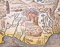
Detail of Abraham Ortelius' 1585 map of Iceland showing Hekla in eruption. The Latin text translates as "The Hekla, perpetually condemned to storms and snow, vomits stones under terrible noise".
-
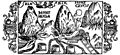
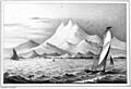
Illustration from Olaus Magnus's Historia de gentibus septentrionalibus, book 2, 1555
-
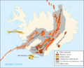
A map of the volcanic systems of Iceland
-
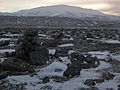
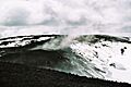
Hekla beyond a snowy field of volcanic ash
-
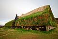
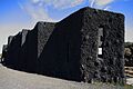
Main building of the replica of Þjóðveldisbærinn Stöng, which was buried under volcanic ash from the 1104 eruption
-
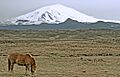
Hekla in 2006 and an Icelandic horse
-
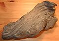
17 cm long volcanic bomb found in the lava-fields of Hekla
-
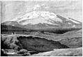
Hekla circa 1851
-
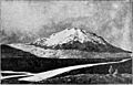
Hekla circa 1893
-
Hekla circa 1904
-
The Pæla lava field in 2009 with a lava river from the 1947 eruption
-
Lava flow from the 1970 eruption, seen in 1971
-
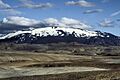
Hekla in winter 2010
-
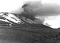
Mount Hekla erupting in 1980. Seen from 4 km NE of the summit.
-
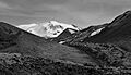
A summer 2009 view of Hekla from the side.
-
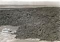
A lava field on Hekla in July 2000
-
Steam at the summit of Hekla
-
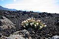
Sea Campion colonising ground close to Hekla
-
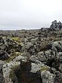
The lichens Stereocaulon vesuvianum and moss Racomitrium ericoides on lava originating from Hekla.
-
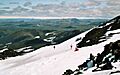
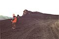
Walkers on the slopes of Hekla (June 2005)
-
The Hekla Centre

See also
- Geography of Iceland
- Iceland plume
- Iceland hotspot
- Volcanism of Iceland
- List of volcanic eruptions in Iceland
- List of volcanoes in Iceland
