Adams, Minnesota facts for kids
Quick facts for kids
Adams, Minnesota
|
|
|---|---|

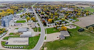
MN-56 runs through the city.
|
|

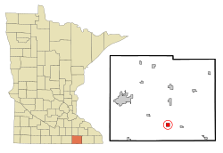
Location in Mower County and the state of Minnesota
|
|
| Country | United States |
| State | Minnesota |
| County | Mower |
| Area | |
| • Total | 1.00 sq mi (2.60 km2) |
| • Land | 1.00 sq mi (2.60 km2) |
| • Water | 0.00 sq mi (0.00 km2) |
| Elevation | 1,283 ft (391 m) |
| Population
(2020)
|
|
| • Total | 683 |
| • Density | 680.96/sq mi (262.89/km2) |
| Time zone | UTC-6 (Central (CST)) |
| • Summer (DST) | UTC-5 (CDT) |
| ZIP code |
55909
|
| Area code(s) | 507 |
| FIPS code | 27-00190 |
| GNIS feature ID | 2393881 |
Adams is a small city in Mower County, Minnesota, United States. It is part of Adams Township. In 2020, the city had a population of 683 people. This was a bit less than its population of 787 in 2010.
Contents
History of Adams
Adams started as a village on January 30, 1868. It was planned out by a person named Selah Chamberlain.
A two-room public school was built in 1869. Later, it was made bigger to have four rooms. The village officially became a city on March 2, 1887.
Over the years, Adams added important services for its residents:
- In 1897, a water system was put in place.
- A volunteer fire department was started in 1898. It was called Adams Hose Co. No. 1.
- A sewage system was installed in 1902. This system was updated in 1958.
- A Catholic school was built in 1903. This helped reduce crowding at the public school.
Today, Adams is part of the Southland school district. The city is home to the sports fields for the school teams.
Geography of Adams
Adams is located in the southern part of Mower County, Minnesota. It is surrounded by the northeast section of Adams Township.
State Highway 56 goes right through the middle of Adams. This road is known as Main Street in town.
- If you go northwest on Highway 56, you will reach Austin, which is the main city of the county, about 17 miles away.
- If you go east-southeast, you will reach Le Roy, about 12 miles away.
- The state line for Iowa is only about 5 miles south of Adams.
According to the U.S. Census Bureau, the city of Adams covers a total area of 1.00 square mile (2.60 square kilometers). All of this area is land. Small streams flow through the southern and western parts of the city. These streams lead to the Little Cedar River. The Little Cedar River then flows south into the Cedar River in Iowa.
People in Adams
| Historical population | |||
|---|---|---|---|
| Census | Pop. | %± | |
| 1880 | 96 | — | |
| 1890 | 216 | 125.0% | |
| 1900 | 573 | 165.3% | |
| 1910 | 576 | 0.5% | |
| 1920 | 609 | 5.7% | |
| 1930 | 574 | −5.7% | |
| 1940 | 674 | 17.4% | |
| 1950 | 663 | −1.6% | |
| 1960 | 806 | 21.6% | |
| 1970 | 771 | −4.3% | |
| 1980 | 797 | 3.4% | |
| 1990 | 756 | −5.1% | |
| 2000 | 800 | 5.8% | |
| 2010 | 787 | −1.6% | |
| 2020 | 683 | −13.2% | |
| U.S. Decennial Census | |||
2010 Census Information
In 2010, there were 787 people living in Adams. These people lived in 304 households, and 188 of these were families. The city had about 779 people per square mile. There were 330 homes in total.
Most of the people in Adams were White (98.3%). A small number were from other racial backgrounds (0.5%) or from two or more races (1.1%). About 1.7% of the population identified as Hispanic or Latino.
About 28.3% of the households had children under 18 living with them. More than half (50.7%) were married couples. About 34.5% of all households were single people living alone. Many older people (65 years or older) lived by themselves (20.4%).
The average age of people in Adams was 46.6 years old.
- 21.3% of residents were under 18.
- 7.3% were between 18 and 24.
- 19.1% were between 25 and 44.
- 20.8% were between 45 and 64.
- 31.4% were 65 years or older.
There were slightly more females (53.6%) than males (46.4%) living in Adams.
Notable People from Adams
- Michael Kramer, a politician from Minnesota.
- Hubert H. Peavey, a politician from Wisconsin.
- Harvey B. Sathre, a politician from Minnesota.
See also
 In Spanish: Adams (Minnesota) para niños

