Afar Triangle facts for kids
The Afar Triangle, also known as the Afar Depression, is a special low-lying area in East Africa. It's a geological depression formed where three parts of the Earth's crust meet. This area is part of the huge Great Rift Valley.
Scientists believe the Afar Triangle is where early humans first evolved. Many very old human-like fossils have been found here. The region crosses the borders of Eritrea, Djibouti, and the Afar Region of Ethiopia. It also holds Lake Assal in Djibouti, which is the lowest point in all of Africa, about 155 meters (509 ft) below sea level.
The Awash River flows into this region. However, it often dries up, leaving a series of salty lakes. The northern part of the Afar Depression is called the Danakil Depression. This area is known for being one of the hottest places on Earth year-round. It gets very little rain and has minimal air movement.
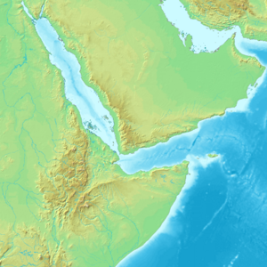
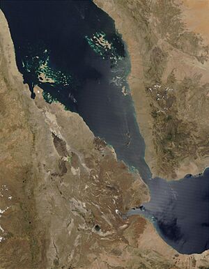
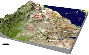
The Afar Triangle is surrounded by high lands. To the west are the Ethiopian Highlands. To the northeast, near the Red Sea, is the Danakil block. To the south is the Somali Plateau, and to the southeast is the Ali-Sabieh block. Many important fossil sites are in the Afar region, including Middle Awash, Hadar, Dikika, and Woranso-Mille. These sites have given us fossils of early human ancestors and ancient tools.
Environment and Climate
Dallol in the Danakil Depression is one of the hottest places on Earth. It barely rains here, with an average of only 100 to 200 millimeters (4 to 8 inches) of rain each year. Closer to the coast, it rains even less. From 1960 to 1966, the average daily temperature in Dallol ranged from 30°C (86°F) in January to 39°C (102°F) in July.
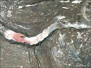
The Awash River flows through the southern part of the Afar Region. It creates a narrow green area that supports plants, animals, and the Afars. The Afars are a nomadic group who live in the Danakil Desert. About 128 kilometers (80 mi) from the Red Sea, the Awash River ends in a chain of salt lakes. Its water evaporates very quickly there. About 1,200 square kilometers (460 sq mi) of the Afar Depression is covered by salt. Mining salt is a main way for many Afar groups to earn money.
The Afar Depression is a desert scrubland. Most plants here can survive with little water. These include small trees, shrubs, and grasses. Many plant-eating animals live here, like Grévy's zebra, Soemmerring's gazelle, and beisa. It is also home to the last group of African wild asses.
Birds in the area include the ostrich, Archer's lark, and the secretary bird. The Mille-Serdo Wildlife Reserve is in the southern part of the plain.
Discoveries of Early Humans
The Afar Triangle is a very important place for finding early human ancestors. It has many ancient sites where fossils of hominins have been found. These include:
- The Middle Awash region.
- Fossils of Ardipithecus ramidus (called "Ardi") and Ardipithecus kadabba.
- The Gawis cranium from Gona.
- Some of the world's oldest stone tools.
- Hadar, where "Lucy" (a fossil of Australopithecus afarensis) was found.
- Dikika, where "Selam" (a fossilized child) was discovered.
In 1994, near the Awash River, scientist Tim D. White found the oldest human ancestor known at that time. It was a 4.4 million-year-old Ar. ramidus. This fossil was an almost complete skeleton of a female hominin, named "Ardi". It took almost 15 years to carefully dig up, protect, and study this amazing fossil.
Geology and Earth's Movements
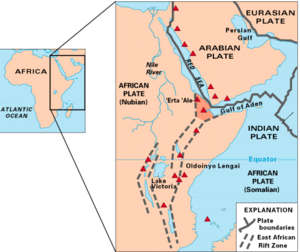
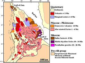
The Afar Depression is formed by a special geological spot called a triple-rifts junction. This is where three huge plates of the Earth's crust are pulling apart. The ridges that form the Red Sea and the Gulf of Aden meet the East African Rift here. These three plates meet near Lake Abbe. The Afar Depression is one of only two places on Earth where a mid-ocean ridge (usually found deep under the ocean) can be seen on land. The other place is Iceland.
Inside the Afar Triangle, the Earth's crust is slowly splitting apart. It moves about 1 to 2 centimeters (0.4 to 0.8 inches) each year along each of the three "rift zones." This causes many earthquakes and long, deep cracks in the ground. The valley floor is also slowly sinking.
In September and October 2005, there were 163 earthquakes stronger than 3.9 magnitude. A volcanic eruption also happened at the Dabbahu and Erta Ale volcanoes. About 2.5 cubic kilometers of melted rock pushed up from deep underground. This created an 8-meter (26 ft) wide gap on the surface, known as the Dabbahu fissure.
Similar eruptions have happened in Teru and Aura areas. Scientists have used 3D laser mapping to study this rift.
The large salt deposits in the region formed over time. Water from the Red Sea would flood the depression and then evaporate, leaving the salt behind. The most recent big flood was about 30,000 years ago.
Geologists believe that in millions of years, the Red Sea will break through the high lands around the Afar Depression and flood the valley permanently. They predict that in about 10 million years, the entire 6,000-kilometer (3,700 mi) long East African Rift will be underwater. This will create a new ocean basin as big as today's Red Sea. It will also separate the Somali Plate and the Horn of Africa from the rest of the continent.
The floor of the Afar Depression is made of lava, mostly a type called basalt. One of Earth's five lava lakes, Erta Ale, is found here, along with Dabbahu Volcano. Scientists think that a huge plume of hot rock from deep inside the Earth is under the Afar Depression. This hot rock melts as it gets closer to the surface, forming the basalt lava.
|
See also
- In Spanish: Depresión de Afar para niños
- Dallol
- Horst
- Lake Assal in Djibouti
- The Afar people who live in the region


