
Agnes Mountain facts for kids
Quick facts for kids Agnes Mountain |
|
|---|---|

Agnes Mountain
|
|
| Highest point | |
| Elevation | 8,119 ft (2,475 m) NAVD 88 |
| Prominence | 1,355 ft (413 m) |
| Geography | |

Agnes Mountain
Location in Washington (state)
|
|
| Location | Chelan County, Washington, U.S. |
| Parent range | North Cascades |
| Topo map | USGS Agnes Mountain |
| Climbing | |
| First ascent | 1936 by W. Ronald Frazier and Dan O'Brien |
| Easiest route | Northeast/South Ridge Route, class 5.6 |
Agnes Mountain is a tall and impressive peak located in the North Cascades mountain range in Washington state, USA. Even though it's not the highest mountain around, it stands out because it rises very steeply from the land below. One expert even called it a "huge, Matterhorn-shaped mountain," meaning it looks a bit like the famous Matterhorn mountain in Europe. For example, its north side drops about 550 meters (1,800 feet) down to Agnes Creek in just 2.4 kilometers (1.5 miles)!
Contents
Climbing Agnes Mountain
First Climbs and Routes
People first climbed Agnes Mountain in 1936. The first climbers were W. Ronald Frazier and Dan O'Brien. They started their climb from the West Fork of Agnes Creek. It took a long time for someone else to climb it again. The second successful climb didn't happen until 1969.
A popular way to climb Agnes Mountain involves a few steps. First, climbers follow the Northeast Ridge of a nearby peak called Asa Peak. Then, they move over to the south ridge of Agnes Mountain. This path includes some tricky parts that need special climbing skills. These sections are rated up to class 5.6, which means they are moderately difficult.
Why Few People Climb It
Agnes Mountain is not climbed very often. This is because it is located deep inside the North Cascades. Getting to the mountain is also very difficult. Plus, it's not one of the tallest mountains in the area. One climbing expert noted that only fourteen groups had successfully climbed it by 1987.
Geology of the North Cascades
Rugged Landscape Formation
The North Cascades area has some of the most rugged land in the Cascade Range. You can see jagged peaks, sharp ridges, and deep valleys carved by glaciers. Many years ago, huge geological events happened. These events created the varied landscape and big changes in elevation across the Cascade Range. This also led to different climates in the region.
How the Mountains Were Built
The Cascade Mountains started forming millions of years ago. This was during a time called the late Eocene Epoch. At that time, the North American Plate (a huge piece of Earth's outer layer) was moving over the Pacific Plate. This movement caused many periods of volcanic activity, where molten rock came to the surface.
Also, small pieces of Earth's crust, called terranes, came together. These pieces were from both the ocean floor and continents. They helped create the North Cascades about 50 million years ago. The Needles, a nearby rock formation, is mostly made from a type of granite. This granite comes from a large underground rock mass called the Golden Horn batholith.
Impact of Glaciers
During the Pleistocene period, which was over two million years ago, glaciers played a big role. These huge sheets of ice moved forward and backward many times. As they moved, they scraped away the land. They left behind piles of rock and debris. The river valleys in the area have a "U" shape. This shape is a clear sign of recent glaciation.
The combination of land being pushed up (uplift) and cracks forming in the Earth's crust (faulting), along with glaciation, has shaped the North Cascades. These processes created the tall peaks and deep valleys we see today.
Images for kids
-
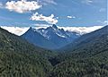
Agnes Mountain from Howard Lake Trail

