Aguacatán facts for kids
Quick facts for kids
Aguacatán
|
|
|---|---|
|
Municipality
|
|

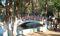
Walkway over Rio San Juan, near the "Nacimiento"
|
|
| Country | |
| Department | |
| Municipality | Aguacatán |
| Government | |
| • Type | Municipal |
| Area | |
| • Municipality | 287 km2 (111 sq mi) |
| Elevation | 1,670 m (5,480 ft) |
| Highest elevation | 3,200 m (10,500 ft) |
| Lowest elevation | 1,350 m (4,430 ft) |
| Population
(Census 2018)
|
|
| • Municipality | 49,607 |
| • Density | 172.85/km2 (447.7/sq mi) |
| • Urban | 8,084 |
| • Ethnicities | Awakatek Mam Kʼicheʼ Chalchitek Ladino |
| • Religions | Roman Catholicism Evangelicalism Maya |
| Climate | Cwb |
| Website | http://www.inforpressca.com/aguacatan/ |
Aguacatán is a town and a municipality in the Guatemalan department of Huehuetenango. It is located about 1,670 meters (5,479 feet) above sea level. The municipality is home to 49,607 people (as of 2018) and covers an area of 287 square kilometers (111 square miles).
Contents
Exploring Aguacatán's Landscape
Aguacatán is nestled in a beautiful mountainous area. If you walk just a few blocks from the central market, you will find yourself surrounded by farmland.
For a long time, Aguacatán was mostly connected by dirt roads. These roads often had problems like erosion, potholes, and landslides. However, in 2006, the roads leading to Huehuetenango, Sacapulas, and Nebaj were paved. This made it much easier for people in Aguacatán to travel. It also connected the town to the Pan American Highway near Huehuetenango. This new connection helps the local economy grow by making it easier to reach markets.
A special natural spot is the Nacimiento del Rio San Juan. This is a natural spring where water bubbles up from a small pool. Pipes around the pool help to collect this water. This water is used to irrigate the farms, which helps the area's agriculture thrive. The Nacimiento also has a park with benches and a two-story viewing area. It's a great place to visit!
People and Languages of Aguacatán
Aguacatán is unique because it is the only municipality in the world where Awakateko is the main native language. However, in some areas just outside the town, like Aldea San Miguel or the mountain road to Chex, the main language spoken is Kʼicheʼ. Awakateko is also spoken in other small communities, such as Llano Coyote, near Rio San Juan. Both Awakateko and Kʼicheʼ are part of the Mayan languages family.
Other languages spoken in the municipality include Mam and Chalchitek. Most people in Aguacatán also speak Spanish.
The main religions practiced here are Roman Catholic and Evangelicalism. Some people also follow the traditional Maya beliefs.
Aguacatán's Economy and Daily Life
Aguacatán has a busy central market that is open most days. You can find many local goods there. Bus services connect Aguacatán to Huehuetenango and other nearby cities, making travel easier. Internet and telephone services are also available for residents.
Sometimes, people from Aguacatán travel to other parts of Guatemala, Mexico, or the United States to find work. This is because economic conditions can be tough. Some families have even settled in places like Tuscarawas County, Ohio.
A Glimpse into Aguacatán's Past
Aguacatán experienced some difficult times during the Civil War, especially in the early 1980s. One community called Chex was affected and is now divided into five smaller areas.
In 2003, there was a local election for mayor. Many candidates ran against the person who was already mayor. The results of this election were debated, and many people wanted a new election. This led to the city offices being closed for several months.
Weather in Aguacatán
Aguacatán has a subtropical highland climate. This means it has mild temperatures all year round, with a rainy season and a drier season.
| Climate data for Aguacatán | |||||||||||||
|---|---|---|---|---|---|---|---|---|---|---|---|---|---|
| Month | Jan | Feb | Mar | Apr | May | Jun | Jul | Aug | Sep | Oct | Nov | Dec | Year |
| Mean daily maximum °C (°F) | 23.6 (74.5) |
24.6 (76.3) |
26.5 (79.7) |
26.8 (80.2) |
26.3 (79.3) |
25.0 (77.0) |
24.7 (76.5) |
25.0 (77.0) |
24.7 (76.5) |
24.0 (75.2) |
24.0 (75.2) |
23.6 (74.5) |
24.9 (76.8) |
| Daily mean °C (°F) | 17.0 (62.6) |
17.6 (63.7) |
19.3 (66.7) |
19.8 (67.6) |
19.9 (67.8) |
19.6 (67.3) |
19.1 (66.4) |
19.0 (66.2) |
19.0 (66.2) |
18.5 (65.3) |
17.9 (64.2) |
17.3 (63.1) |
18.7 (65.6) |
| Mean daily minimum °C (°F) | 10.5 (50.9) |
10.7 (51.3) |
12.1 (53.8) |
12.9 (55.2) |
13.6 (56.5) |
14.2 (57.6) |
13.5 (56.3) |
13.1 (55.6) |
13.3 (55.9) |
13.1 (55.6) |
11.8 (53.2) |
11.1 (52.0) |
12.5 (54.5) |
| Average precipitation mm (inches) | 35 (1.4) |
29 (1.1) |
40 (1.6) |
63 (2.5) |
147 (5.8) |
353 (13.9) |
263 (10.4) |
225 (8.9) |
316 (12.4) |
243 (9.6) |
98 (3.9) |
46 (1.8) |
1,858 (73.3) |
| Source: Climate-Data.org | |||||||||||||
 |
Nebaj, Quiché Department municipality |  |
||
| Chiantla, Huehuetenango Department municipality | Sacapulas, Quiche Department municipality | |||
| Huehuetenango, Huehuetenango, Huehuetenango Department municipality | Huehuetenango, Huehuetenango, Huehuetenango Department municipality |
See also
 In Spanish: Aguacatán para niños
 | James Van Der Zee |
 | Alma Thomas |
 | Ellis Wilson |
 | Margaret Taylor-Burroughs |


