Aguirre, Salinas, Puerto Rico facts for kids
Quick facts for kids
Aguirre
|
|
|---|---|
|
Barrio
|
|

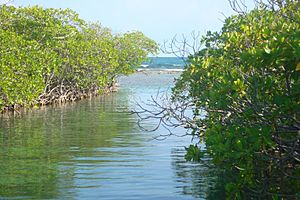
Cayo Matias
|
|

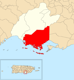
Location of Aguirre within the municipality of Salinas shown in red
|
|
| Commonwealth | |
| Municipality | |
| Area | |
| • Total | 36.22 sq mi (93.8 km2) |
| • Land | 19.49 sq mi (50.5 km2) |
| • Water | 16.73 sq mi (43.3 km2) |
| Elevation | 3 ft (0.9 m) |
| Population
(2010)
|
|
| • Total | 14,005 |
| • Density | 719.3/sq mi (277.7/km2) |
| Source: 2010 Census | |
| Time zone | UTC−4 (AST) |
| ZIP code |
00704
|
Aguirre is a neighborhood, also called a barrio, in the town of Salinas, Puerto Rico. In 2010, about 14,000 people lived there.
Contents
A Look at Aguirre's Past
Aguirre was once part of Spain. After the Spanish–American War in 1898, Puerto Rico became a territory of the United States. In 1899, a count showed 1,291 people lived in Aguirre.
Aguirre as a Town
Aguirre used to be its own small town, known as a municipality. In the 1990s, it joined with Salinas. Before that, Aguirre was the smallest town in Puerto Rico. Now, Cataño, near San Juan, holds that title.
Important Sugar Factory
For many years, Aguirre's main way to make money was a big sugar factory. This factory was called the Central Azucarera de Aguirre. The factory area is so important that it was added to the U.S. National Register of Historic Places in 2002.
Aguirre still has a "central" building today. It is now run by the Autoridad de Energía Eléctrica de Puerto Rico. This is a government company that provides energy. In 2016, a fire happened at the plant due to an oil leak. No one was hurt, but the plant could not work for three weeks.
The World Monuments Fund organization listed the Central Azucarera de Aguirre on its 2020 World Monuments Watch. This group plans to use the site to teach people in Puerto Rico how to build with wood.
How Aguirre's Population Grew
The number of people living in Aguirre has changed over the years:
| Historical population | |||
|---|---|---|---|
| Census | Pop. | %± | |
| 1900 | 1,291 | — | |
| 1910 | 3,996 | 209.5% | |
| 1920 | 5,807 | 45.3% | |
| 1930 | 6,796 | 17.0% | |
| 1940 | 7,811 | 14.9% | |
| 1950 | 9,152 | 17.2% | |
| 1960 | 8,645 | −5.5% | |
| 1970 | 0 | −100.0% | |
| 1980 | 8,772 | — | |
| 1990 | 10,638 | 21.3% | |
| 2000 | 12,128 | 14.0% | |
| 2010 | 14,005 | 15.5% | |
| U.S. Decennial Census 1899 (shown as 1900) 1910-1930 1930-1950 1980-2000 2010 |
|||
Getting Around Aguirre
You can reach Aguirre, like the rest of Salinas, by car. Puerto Rico Highway 1 connects the two biggest cities in Puerto Rico: San Juan and Ponce.
The closest airport for commercial flights is Mercedita Airport in Ponce. For international flights, the main airport is Luis Muñoz Marín International Airport in San Juan.
See also
 In Spanish: Aguirre (Salinas) para niños
 | Janet Taylor Pickett |
 | Synthia Saint James |
 | Howardena Pindell |
 | Faith Ringgold |


