Akron, New York facts for kids
Quick facts for kids
Akron
|
|
|---|---|
|
Village
|
|
| Village of Akron | |

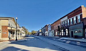
Main Street
|
|

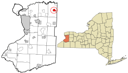
Location in Erie County and the state of New York.
|
|
| Country | United States |
| State | New York |
| County | Erie |
| Town | Newstead |
| Area | |
| • Total | 2.01 sq mi (5.21 km2) |
| • Land | 2.01 sq mi (5.21 km2) |
| • Water | 0.00 sq mi (0.00 km2) |
| Elevation | 741 ft (226 m) |
| Population
(2020)
|
|
| • Total | 2,888 |
| • Density | 1,435.39/sq mi (554.34/km2) |
| Time zone | UTC-5 (Eastern (EST)) |
| • Summer (DST) | UTC-4 (EDT) |
| ZIP code |
14001
|
| Area code(s) | 716 |
| FIPS code | 36-00441 |
| GNIS feature ID | 0942224 |
Akron is a small village located in Erie County, New York, United States. In 2020, about 2,888 people lived there. The name "Akron" comes from a Greek word meaning "summit" or "high point," which makes sense because the village is on the side of a hill. It's also part of the larger Buffalo–Niagara Falls area.
Akron is found within the town of Newstead. A main road, NY 93, goes right through the village.
Contents
History of Akron
The area where Akron now stands was first settled around 1829. This happened after land was bought from the local Native American tribes. The early settlers were drawn to Akron Falls, which provided water power for mills and other businesses.
Akron officially became an "incorporated village" in 1849. This means it got its own local government. As it grew, it joined with a nearby community called Fallkirk. By 1880, Akron had about 1,050 people.
At that time, Akron was important for making cement. This was because there were many natural deposits of gypsum nearby, which is a key ingredient for cement. Besides cement, the village also produced cigars.
Who are some famous people from Akron?
- Dick Beyer
- Dennis E. Nolan
Geography and Nature in Akron
Akron is located northeast of the city of Buffalo. The village covers about 2.0 square miles (5.2 square kilometers) of land.
Right next to Akron is the Tonawanda Reservation, which belongs to the Seneca Nation. Most of this reservation is in a different county, Genesee County.
You can find a small airport, Akron Airport, on the eastern side of the village. A large part of Akron Falls Park is also within the village limits. The beautiful falls in the park are part of Murder Creek, a stream that flows through the park and the village.
Akron's Population Over Time
| Historical population | |||
|---|---|---|---|
| Census | Pop. | %± | |
| 1860 | 462 | — | |
| 1870 | 444 | −3.9% | |
| 1880 | 1,036 | 133.3% | |
| 1890 | 1,492 | 44.0% | |
| 1900 | 1,585 | 6.2% | |
| 1910 | 1,677 | 5.8% | |
| 1920 | 1,960 | 16.9% | |
| 1930 | 2,188 | 11.6% | |
| 1940 | 2,263 | 3.4% | |
| 1950 | 2,481 | 9.6% | |
| 1960 | 2,841 | 14.5% | |
| 1970 | 2,863 | 0.8% | |
| 1980 | 2,971 | 3.8% | |
| 1990 | 2,906 | −2.2% | |
| 2000 | 3,085 | 6.2% | |
| 2010 | 2,868 | −7.0% | |
| 2020 | 2,888 | 0.7% | |
| U.S. Decennial Census | |||
In 2000, Akron had a population of 3,085 people. Most of the people living in Akron were White (97.57%), with smaller percentages of African American, Native American, and Asian residents. About 0.65% of the population was Hispanic or Latino.
The village has a mix of families and individuals. About 23.7% of the population was under 18 years old, and 18.4% were 65 or older. The average age in Akron was 39 years.
Fun Places and Attractions in Akron
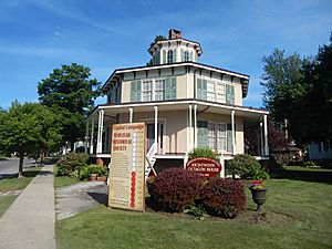
- The Rich-Twinn Octagon House is a very unusual building shaped like an octagon (an eight-sided figure). It's open to the public, and you can learn about its unique architecture. The Newstead Historical Society also runs the Knight-Sutton Museum, which has exhibits about local history and culture.
- Russell Park is a popular gathering spot in Akron. It was set aside as a park forever by one of Akron's founders. There used to be a fountain where the gazebo is now, but it was replaced to save on upkeep costs.
- Akron has one school, Akron Central School. All students from pre-kindergarten to 12th grade attend classes in this single building.
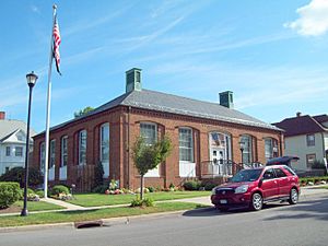
- The U.S. Post Office (Akron, New York) is a historic building. Inside, you can see a special mural called Early Mail Route to Akron. It was painted in 1941 by artist Elizabeth Logan as part of a government program called the WPA.
- The Akron Fire Company helps keep the village and parts of the Town of Newstead safe, working with the Newstead Fire Company.
- In July 2013, the first park golf course in the United States opened in Akron. This sport was brought to America by Akron native Dick "The Destroyer" Beyer, who was a professional wrestler and spent many years in Japan, where park golf began.
See also
 In Spanish: Akron (Nueva York) para niños
 | Bayard Rustin |
 | Jeannette Carter |
 | Jeremiah A. Brown |


