Allenville, Missouri facts for kids
Quick facts for kids
Allenville, Missouri
|
|
|---|---|
|
Village
|
|
| Village of Allenville | |

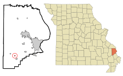
Location of Allenville, Missouri
|
|
| Country | United States |
| State | Missouri |
| County | Cape Girardeau |
| Named for | Thomas Allen |
| Area | |
| • Total | 0.15 sq mi (0.40 km2) |
| • Land | 0.15 sq mi (0.40 km2) |
| • Water | 0.00 sq mi (0.00 km2) |
| Elevation | 348 ft (106 m) |
| Population
(2020)
|
|
| • Total | 95 |
| • Density | 612.90/sq mi (237.20/km2) |
| Time zone | UTC-6 (Central (CST)) |
| • Summer (DST) | UTC-5 (CDT) |
| FIPS code | 29-00748 |
| GNIS feature ID | 2397938 |
Allenville is a small village located in Cape Girardeau County, Missouri, in the United States. It's part of a larger area that includes the cities of Cape Girardeau and Jackson. According to the 2020 census, 95 people lived in Allenville.
Contents
A Look Back at Allenville's History
Allenville got its name from Tom Allen. He was the person who built the Belmont Branch Railroad. The village was officially planned out, or platted, in 1869. This happened when the railroad line was extended to reach that spot.
The community was also a stop on the old Lone Star Trail. This was a path where cattle were herded all the way from Texas to the Allenville railroad station. From there, the cattle could be transported further by train. A post office opened in Allenville in 1869 and served the community until 1974.
Where is Allenville?
Allenville is located in Missouri, near a waterway called the Headwater Diversion Channel. It sits between two other towns: Whitewater to its northwest and Delta to its southeast.
The United States Census Bureau reports that the village covers a total area of about 0.16 square miles (0.40 square kilometers). All of this area is land, with no water.
How Many People Live Here?
| Historical population | |||
|---|---|---|---|
| Census | Pop. | %± | |
| 1880 | 122 | — | |
| 1890 | 173 | 41.8% | |
| 1900 | 148 | −14.5% | |
| 1910 | 257 | 73.6% | |
| 1920 | 270 | 5.1% | |
| 1930 | 190 | −29.6% | |
| 1990 | 69 | — | |
| 2000 | 104 | 50.7% | |
| 2010 | 116 | 11.5% | |
| 2020 | 95 | −18.1% | |
| U.S. Decennial Census 2020 | |||
Allenville in 2010
The census from 2010 showed that 116 people lived in Allenville. There were 42 households, which are groups of people living in the same home. Out of these, 33 were families.
The population density was about 725 people per square mile (280 people per square kilometer). This means that for every square mile of land, there were about 725 people. There were 49 housing units in total.
Most of the people in the village, about 99.14%, were identified as White. A small number, 0.86%, were from two or more racial backgrounds.
Households and Families
- About 40.5% of the households had children under 18 years old living with them.
- Most households, 64.3%, were married couples living together.
- In 9.5% of households, a female was the head of the house without a husband present.
- In 4.8% of households, a male was the head of the house without a wife present.
- About 21.4% of households were not families.
- Nearly one-fifth (19.0%) of all households had only one person living there.
- About 4.8% of households had someone living alone who was 65 years old or older.
The average household had about 2.76 people. The average family had about 3.09 people.
Age and Gender
The median age in Allenville was 35.5 years. This means half the people were younger than 35.5 and half were older.
- About 31% of the residents were under 18 years old.
- Only 3.4% were between 18 and 24 years old.
- About 25% were between 25 and 44 years old.
- Around 26.7% were between 45 and 64 years old.
- About 13.8% of the residents were 65 years old or older.
When looking at gender, 56.9% of the people in the village were male, and 43.1% were female.
See also
 In Spanish: Allenville (Misuri) para niños
 | Bayard Rustin |
 | Jeannette Carter |
 | Jeremiah A. Brown |

