Municipal District of Taber facts for kids
Quick facts for kids
Municipal District of Taber
|
||
|---|---|---|
|
||

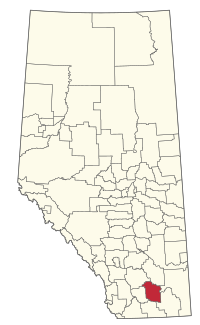
Location within Alberta
|
||
| Country | Canada | |
| Province | Alberta | |
| Region | Southern Alberta | |
| Census division | 2 | |
| Established | 1954 | |
| Incorporated | 1954 | |
| Area
(2021)
|
||
| • Land | 4,160.47 km2 (1,606.37 sq mi) | |
| Population
(2021)
|
||
| • Total | 7,447 | |
| • Density | 1.8/km2 (5/sq mi) | |
| • Municipal census (2016) | 7,173 | |
| Time zone | UTC−7 (MST) | |
| • Summer (DST) | UTC−6 (MDT) | |
The Municipal District of Taber (often called the MD of Taber) is a special local government area in southern Alberta, Canada. It is a large rural area that includes several smaller communities. The MD of Taber was officially created in 1954.
Contents
Exploring the MD of Taber's Geography
The MD of Taber covers a large area of land. It is home to different types of communities. These communities vary in size and how they are governed.
Towns and Villages in the Area
Some towns and villages are completely surrounded by the MD of Taber. They have their own local governments.
- Taber is a town and is where the main office for the MD of Taber is located.
- Vauxhall is another town in the area.
- Barnwell is a village found within the MD of Taber.
Hamlets and Localities
Besides towns and villages, the MD of Taber also contains smaller communities called hamlets and localities. These places are directly governed by the MD of Taber council.
- Hamlets:
- Enchant
- Grassy Lake
- Hays
- Johnson's Addition
- Purple Springs
- Other Places:
Population and People
Every few years, Canada counts its population. This count is called a census. It helps us understand how many people live in an area.
How Many People Live Here?
In the 2021 Census, 7,447 people lived in the MD of Taber. These people lived in 1,971 homes. This number was a bit higher than in 2016.
In 2016, the census counted 7,098 people. The MD of Taber also does its own local count. In 2016, their local count showed 7,173 people. This means the population has been growing steadily.


