Vauxhall, Alberta facts for kids
Quick facts for kids
Vauxhall
|
|
|---|---|
|
Town
|
|
| Town of Vauxhall | |

Main Street in Vauxhall
|
|
| Motto(s):
Potato Capital of the West
|
|
| Country | Canada |
| Province | Alberta |
| Region | Southern Alberta |
| Census division | 2 |
| Municipal district | Municipal District of Taber |
| Incorporated | |
| • Village | December 31, 1949 |
| • Town | January 1, 1961 |
| Area
(2021)
|
|
| • Land | 2.71 km2 (1.05 sq mi) |
| Elevation | 779 m (2,556 ft) |
| Population
(2021)
|
|
| • Total | 1,286 |
| • Density | 474.7/km2 (1,229/sq mi) |
| Time zone | UTC−7 (MST) |
| • Summer (DST) | UTC−6 (MDT) |
| Highways | Highway 36 Highway 864 |
Vauxhall is a small town in southern Alberta, Canada. It is surrounded by the Municipal District of Taber. You can find Vauxhall on Alberta Highway 36, also known as the Veteran Memorial Highway.
The town is about 36 kilometers (22 miles) north of Taber. It is also 69 kilometers (43 miles) south of Brooks. Vauxhall is located in the flat prairie lands. It sits between the Bow River and the Oldman River.
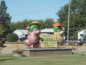
Vauxhall is famous for its potatoes! It is known as the "Potato Capital of the West." You might even see their potato mascots, Sammy and Samantha Spud, welcoming visitors.
Contents
People Living in Vauxhall
This section tells us about the number of people who live in Vauxhall. It also explains how the population has changed over time.
How Many People Live Here?
In 2021, the Canadian Census counted 1,286 people living in Vauxhall. These people lived in 436 homes. This was a small increase from the 1,222 people counted in 2016.
The town covers a land area of about 2.71 square kilometers. This means there were about 475 people living in each square kilometer in 2021.
Getting Around Vauxhall
Vauxhall has its own small airport. This airport is located about 5 kilometers (3 miles) south of the town. It helps people travel to and from Vauxhall.
Learning in Vauxhall
Kids in Vauxhall go to two main schools. There is Vauxhall High School for older students. Younger students attend Vauxhall Elementary School.
Vauxhall's Weather and Land
Vauxhall is located in a dry area of southern Alberta. This type of climate is called semi-arid. It means the area does not get a lot of rain.
What is the Climate Like?
Winters in Vauxhall can be very cold. However, a special wind called a Chinook wind sometimes blows. This wind comes from the Rocky Mountains. It can make winter days much warmer than usual.
The hottest temperature ever recorded in Vauxhall was 40.6 degrees Celsius (105.1 degrees Fahrenheit). This happened on July 16, 1919, and again on July 20, 1921. The coldest temperature ever recorded was a very chilly -48.9 degrees Celsius (-56.0 degrees Fahrenheit). This was on January 12, 1916.
| Climate data for Vauxhall, 1981–2010 normals, extremes 1913–present | |||||||||||||
|---|---|---|---|---|---|---|---|---|---|---|---|---|---|
| Month | Jan | Feb | Mar | Apr | May | Jun | Jul | Aug | Sep | Oct | Nov | Dec | Year |
| Record high °C (°F) | 19.4 (66.9) |
24.0 (75.2) |
27.5 (81.5) |
33.3 (91.9) |
35.0 (95.0) |
37.8 (100.0) |
40.6 (105.1) |
39.9 (103.8) |
37.8 (100.0) |
31.0 (87.8) |
22.2 (72.0) |
17.5 (63.5) |
40.6 (105.1) |
| Mean daily maximum °C (°F) | −2.9 (26.8) |
0.5 (32.9) |
6.1 (43.0) |
13.7 (56.7) |
19.0 (66.2) |
22.3 (72.1) |
25.5 (77.9) |
25.8 (78.4) |
20.7 (69.3) |
13.4 (56.1) |
4.5 (40.1) |
−0.6 (30.9) |
12.3 (54.1) |
| Daily mean °C (°F) | −9.2 (15.4) |
−6.1 (21.0) |
−0.9 (30.4) |
6.0 (42.8) |
11.4 (52.5) |
15.4 (59.7) |
17.7 (63.9) |
17.4 (63.3) |
12.4 (54.3) |
5.7 (42.3) |
−1.9 (28.6) |
−6.8 (19.8) |
5.1 (41.2) |
| Mean daily minimum °C (°F) | −15.4 (4.3) |
−12.7 (9.1) |
−7.8 (18.0) |
−1.6 (29.1) |
3.8 (38.8) |
8.6 (47.5) |
10.0 (50.0) |
8.9 (48.0) |
4.1 (39.4) |
−1.9 (28.6) |
−8.2 (17.2) |
−12.9 (8.8) |
−2.1 (28.2) |
| Record low °C (°F) | −48.9 (−56.0) |
−43.3 (−45.9) |
−38.5 (−37.3) |
−25.6 (−14.1) |
−11.7 (10.9) |
−2.2 (28.0) |
−0.6 (30.9) |
−1 (30) |
−10.6 (12.9) |
−29.4 (−20.9) |
−36 (−33) |
−45 (−49) |
−48.9 (−56.0) |
| Average precipitation mm (inches) | 11.1 (0.44) |
10.0 (0.39) |
15.3 (0.60) |
25.1 (0.99) |
40.0 (1.57) |
72.9 (2.87) |
32.9 (1.30) |
32.9 (1.30) |
34.9 (1.37) |
14.4 (0.57) |
15.0 (0.59) |
11.6 (0.46) |
316.0 (12.44) |
| Average rainfall mm (inches) | 0.0 (0.0) |
0.2 (0.01) |
2.3 (0.09) |
17.7 (0.70) |
35.7 (1.41) |
72.9 (2.87) |
32.9 (1.30) |
32.5 (1.28) |
33.9 (1.33) |
9.0 (0.35) |
1.8 (0.07) |
0.6 (0.02) |
239.5 (9.43) |
| Average snowfall cm (inches) | 11.1 (4.4) |
9.8 (3.9) |
12.9 (5.1) |
7.4 (2.9) |
4.2 (1.7) |
0.0 (0.0) |
0.0 (0.0) |
0.4 (0.2) |
1.0 (0.4) |
5.4 (2.1) |
13.2 (5.2) |
10.9 (4.3) |
76.4 (30.1) |
| Source: Environment Canada | |||||||||||||
 | Shirley Ann Jackson |
 | Garett Morgan |
 | J. Ernest Wilkins Jr. |
 | Elijah McCoy |


