
Arbignieu facts for kids
Quick facts for kids
Arbignieu
|
||
|---|---|---|
|
Part of Arboys en Bugey
|
||

Church in Peyzieu
|
||
|
||

Arbignieu
Location in France

Arbignieu
Location in Auvergne-Rhône-Alpes
|
||
| Country | France | |
| Region | Auvergne-Rhône-Alpes | |
| Department | Ain | |
| Arrondissement | Belley | |
| Canton | Belley | |
| Commune | Arboys en Bugey | |
| Area
1
|
13.07 km2 (5.05 sq mi) | |
| Population
(2021)
|
525 | |
| • Density | 40.17/km2 (104.04/sq mi) | |
| Time zone | UTC+01:00 (CET) | |
| • Summer (DST) | UTC+02:00 (CEST) | |
| Postal code |
01300
|
|
| Elevation | 221–495 m (725–1,624 ft) (avg. 300 m or 980 ft) |
|
| 1 French Land Register data, which excludes lakes, ponds, glaciers > 1 km2 (0.386 sq mi or 247 acres) and river estuaries. | ||
.svg)
Arbignieu was a small town, or 'commune,' in eastern France. It was located in the Ain area, which is part of the Auvergne-Rhône-Alpes region. On January 1, 2016, Arbignieu joined with other towns to form a new, larger commune called Arboys en Bugey.
Contents
Where Arbignieu Was Located
Arbignieu was about 4 kilometers (2.5 miles) southwest of a town called Belley. It was also about 30 kilometers (18.6 miles) northwest of Chambery. A walking path, the 'Tour du Bugey' trail, went through the area.
The area was known for its special wine called 'Roussette du Bugey-Arbignieu.' This wine had an 'AOC' label. 'AOC' stands for Appellation d'origine contrôlée, which means it met strict rules about where and how it was made. This ensures its quality and unique character.
Roads and Hamlets
You could reach Arbignieu using the D69 road from Belley. This road continued west to Colomieu. Another road, the D100, also went through the eastern part of the commune.
Besides Arbignieu itself, there were three smaller villages, or 'hamlets,' in the commune. These were Thoys, Slignieu, and Peyzieu. The land around Arbignieu was about half farmland and half forest. Most of the forest was along the western edge.
Rivers and Waterways
The Furans river formed the eastern border of the commune. It then flowed east to join the larger Rhône river. Another stream, the Ruisseau d'Armaille, flowed from west to east across the commune and into the Furans.
 |
Saint-Germain-les-Paroisses | Andert-et-Condon | Belley | |
| Colomieu | Petit Brens | |||
| Saint-Benoit | Prémeyzel | La Balme |
Local Government
A 'mayor' is the leader of a town or commune. They are in charge of local services and decisions. Here are some of the people who served as mayor of Arbignieu:
| From | To | Name |
|---|---|---|
| 1995 | 2014 | Daniel Girardet |
| 2014 | 2015 | Charles Berger |
Population of Arbignieu
The people who lived in Arbignieu were called Arbignolans (for males) or Arbignolanes (for females). The number of people living in the commune changed over time:
| Historical population | ||
|---|---|---|
| Year | Pop. | ±% p.a. |
| 2006 | 464 | — |
| 2011 | 484 | +0.85% |
| 2021 | 525 | +0.82% |
| Source: INSEE | ||
Places to See
Arbignieu had several interesting historical sites and monuments:
- The Ball of Gargantua: These are special stones with cup-shaped hollows.
- The ruins of the Chateau of Longecombe: This was once a castle owned by the Luyrieu family in the 1300s.
- The Fortified house of Thoy or Thuey: This was a strong house built to protect people.
- General Parra's House (1700s): This old house is located in the hamlet of Sillignieu.
- The Church of Peyzieu: This church is in the small village of Peyzieu, which was part of Arbignieu.
Famous People from Arbignieu
- Césaire Nivière (1799-1879): He was an agronomist, which means he studied farming and how to make it better. He was born in Peyzieu, a hamlet within Arbignieu.
Images for kids
-
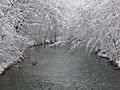
The Furans river near Peyzieu, covered in snow.

See also
 In Spanish: Arbignieu para niños
