
Ardleigh Green facts for kids
Quick facts for kids Ardleigh Green |
|
|---|---|

Ardleigh Green
|
|
| OS grid reference | TQ535895 |
| • Charing Cross | 15.5 mi (24.9 km) WSW |
| London borough | |
| Ceremonial county | Greater London |
| Region | |
| Country | England |
| Sovereign state | United Kingdom |
| Post town | HORNCHURCH |
| Postcode district | RM11 |
| Dialling code | 01708 |
| Police | Metropolitan |
| Fire | London |
| Ambulance | London |
| EU Parliament | London |
| UK Parliament |
|
| London Assembly |
|
Ardleigh Green is a small area in east London, England. It is part of the London Borough of Havering. This area is mostly made up of homes. It is about 15.5 miles (25 km) east-northeast of Charing Cross, a famous spot in central London.
Contents
History of Ardleigh Green
How Ardleigh Green Got its Name
The area we now call Ardleigh Green used to be a tiny village, or "hamlet," within the larger area of Hornchurch. For a long time, until the early 1600s, it was known as Hardley Green.
The name Haddeleye was first written down a long time ago. Over time, this name slowly changed into "Ardleigh." This change happened naturally as people spoke the name. The original meaning of the name comes from old English words. It likely meant "heath clearing" or "clearing in the heather." A "clearing" is an open space in a forest or a wild area. "Heather" is a type of small plant that grows in open, often wild, places. The name "Hardley Green" was last seen on a map in 1883.
Ardleigh Green was once part of a special area called the Liberty of Havering. A "liberty" was a historical area that had some special rights and rules, different from the surrounding county.
Geography of Ardleigh Green
Ardleigh Green has a small group of shops where people can buy things. The area also has natural streams. These streams are the beginning of a larger stream called The Ravensbourne. This stream flows for a short distance before joining the River Rom.
Getting Around Ardleigh Green
You can reach Ardleigh Green by train or bus.
- The closest train stations are Gidea Park, Harold Wood, and Emerson Park.
- There are also London Bus services. These buses connect Ardleigh Green to nearby places like Hornchurch, Gidea Park, and Romford.
Education in Ardleigh Green
Ardleigh Green has several places for learning.
- There is a combined junior and primary school for younger students.
- The area is also home to Havering College of Further and Higher Education. This college offers courses for older students and adults.
Images for kids
-
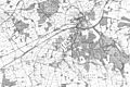
An old map from 1883 showing Ardleigh Green as a small village.

