Argyle (village), New York facts for kids
Quick facts for kids
Argyle
|
|
|---|---|
|
Village
|
|

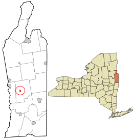
Location in Washington County and the state of New York.
|
|
| Country | United States |
| State | New York |
| County | Washington |
| Area | |
| • Total | 0.32 sq mi (0.82 km2) |
| • Land | 0.32 sq mi (0.82 km2) |
| • Water | 0.00 sq mi (0.00 km2) |
| Elevation | 285 ft (87 m) |
| Population
(2020)
|
|
| • Total | 289 |
| • Density | 911.67/sq mi (352.29/km2) |
| Time zone | UTC-5 (Eastern (EST)) |
| • Summer (DST) | UTC-4 (EDT) |
| ZIP code |
12809
|
| Area code(s) | 518 838 |
| FIPS code | 36-02550 |
| GNIS feature ID | 0942550 |
Argyle is a small village located in Washington County, New York, United States. It's part of a larger area called the Glens Falls Metropolitan Statistical Area. In 2020, about 289 people lived in the village.
Both the village and the wider area (called a "town") of Argyle get their name from Argyllshire, a place in Scotland. Many of the first people to settle here in the mid-1700s came from Scotland. Other settlers from Germany, Ireland, the Netherlands, and Poland also moved to this area. In the 1800s, people in Argyle were active in helping enslaved people find freedom through the Underground Railroad. A stream called Moses Kill helped power mills in the village. Later, in the early 1900s, Argyle got a library and running water for its residents.
Contents
Fun Community Events
Argyle is a lively place with many community events throughout the year!
- Memorial Day Parade: The Argyle American Legion Post 1518 leads a parade to honor those who served our country.
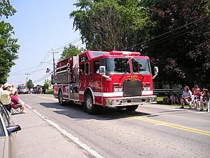
- July 4th Parade and Chicken Barbeque: The Argyle Fire-Rescue Department hosts a fun parade and a delicious chicken barbeque.
- Argyle Methodist Church Election Dinner: A community dinner held by the local church.
- Thanksgiving Holiday Meal: F.E.A.S.T (Friends Ensuring A Super Thanksgiving) provides a traditional Thanksgiving meal for anyone who wants to join.
- Argyle Free Library Book Fair: Held on July 4th, it's a great chance to find new books.
- Carl Lufkin Memorial Pull for the Cure: In July, people gather for a garden tractor and 4WD truck pull. This event raises money for charities that fight cancer.
- Haunted House: On weekends in October, the Ransom Stiles house turns into a spooky haunted house!
- Town-Wide Garage Sale: Over the Columbus Day Holiday, many families in Argyle have garage sales all over town.
Thistle Day Celebration
On September 18, 2021, Argyle started a special tradition called "Thistle Day." A thistle is the national flower of Scotland, and this day celebrates Argyle's Scottish roots. This celebration had not happened for almost 100 years before it was brought back! Since then, it has become a yearly event. It includes:
- A big bonfire and fireworks
- Scottish games
- Traditional Scottish music
- Delicious food and drinks
- Community booths
History of Argyle Village
The land that became Argyle village was first set aside on May 21, 1764. This was known as the Argyle Patent. At that time, it was part of Albany County in the British colony called the Province of New York.
After the American Revolutionary War, the area became part of the new State of New York. Washington County, where Argyle is located, was named to honor American General George Washington. The village of Argyle grew a bit slower than the surrounding town. It was officially recognized as a village on March 27, 1838.
For a long time, from 1806 to 1906, the main office for Washington County's records (the County Clerk's Office) was located right in Argyle village. This was because Argyle was in a central spot in the county. From 1870 to 1906, this office was in the brick building where the Glens Falls National Bank is today.
Geography of Argyle
The village of Argyle covers a total area of about 0.4 square miles (1.0 km2). All of this area is land.
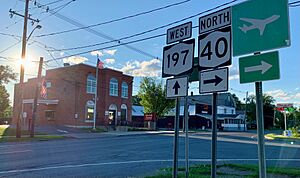
Two main state roads pass through Argyle:
- NY Route 40: This road goes north and south through both the town and village of Argyle.
- NY Route 197: This road goes east and west. It crosses the Hudson River near Fort Edward and ends in Argyle village where it meets NY Route 40.
The Moses Kill is a stream that flows through the village. Early settlers used this stream's water power for their small mills. The Moses Kill goes under NY Route 197 and eventually flows into the Hudson River, south of Fort Edward.
Population Information
| Historical population | |||
|---|---|---|---|
| Census | Pop. | %± | |
| 1840 | 500 | — | |
| 1860 | 375 | — | |
| 1870 | 351 | −6.4% | |
| 1880 | 316 | −10.0% | |
| 1890 | 158 | −50.0% | |
| 1900 | 264 | 67.1% | |
| 1910 | 231 | −12.5% | |
| 1920 | 198 | −14.3% | |
| 1930 | 245 | 23.7% | |
| 1940 | 226 | −7.8% | |
| 1950 | 351 | 55.3% | |
| 1960 | 355 | 1.1% | |
| 1970 | 392 | 10.4% | |
| 1980 | 320 | −18.4% | |
| 1990 | 295 | −7.8% | |
| 2000 | 289 | −2.0% | |
| 2010 | 306 | 5.9% | |
| 2020 | 289 | −5.6% | |
| U.S. Decennial Census | |||
In 2020, there were 289 people living in the Village of Argyle. This means there were about 810.9 people per square mile (313.1 people/km2) living in each square mile.
The people living in Argyle come from different backgrounds:
- Most residents (about 91.3%) are White.
- About 0.35% are Black or African American.
- About 6.9% are from other racial groups.
- About 2.77% of the population identifies as Hispanic or Latino.
The average age of people in the village was about 38.3 years old. About 32% of the population was under 18 years old, and almost 20% were 65 years or older.
The average income for a household in Argyle was $52,500. For families, the average income was $60,625.
See Also
 In Spanish: Argyle (villa) para niños
 | Charles R. Drew |
 | Benjamin Banneker |
 | Jane C. Wright |
 | Roger Arliner Young |


