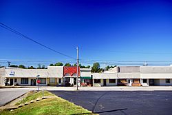
Arlington, Kentucky facts for kids
Quick facts for kids
Arlington, Kentucky
|
|
|---|---|

Walnut Street
|
|

Location of Arlington in Carlisle County, Kentucky.
|
|
| Country | United States |
| State | Kentucky |
| County | Carlisle |
| Area | |
| • Total | 0.38 sq mi (0.97 km2) |
| • Land | 0.38 sq mi (0.97 km2) |
| • Water | 0.00 sq mi (0.00 km2) |
| Elevation | 351 ft (107 m) |
| Population
(2020)
|
|
| • Total | 264 |
| • Density | 702.13/sq mi (270.93/km2) |
| Time zone | UTC-6 (Central (CST)) |
| • Summer (DST) | UTC-5 (CDT) |
| ZIP code |
42021
|
| Area codes | 270 & 364 |
| FIPS code | 21-02044 |
| GNIS feature ID | 0486029 |
Arlington is a small city in Carlisle County, Kentucky, in the United States. It is known as a "home rule-class city," which means it has the power to govern itself on local matters.
In 2020, about 264 people lived in Arlington. This number was a bit lower than in 2010, when 324 people lived there. The city was officially started by the state government in 1876. Arlington is part of the larger Paducah, KY-IL Metropolitan area.
Contents
History of Arlington
Arlington was founded in 1873. It began as a stop along a railroad line that later became part of the Illinois Central Railroad.
The new city was first called "Neville." This name came from Robert Buckner Neville, who owned the land where the city was built. Some people wanted to change the name to "Holtsville" after a local store owner named Tom Holt. To avoid any arguments, the railroad decided on the name "Arlington." This name was chosen because it was the hometown of a railroad official, Arlington Heights, Virginia. The city officially became a town in 1876.
In 1886, Carlisle County was created. Arlington was first chosen to be the county seat. This means it would be the main town where the county government offices were located. However, another nearby city, Bardwell, argued that it was a better choice. Bardwell was more in the center of the county. County officials agreed and soon moved the county seat to Bardwell.
Geography
Arlington is located in the southern part of Carlisle County. You can find it at these coordinates: 36.791299 degrees North and 89.011398 degrees West.
Two important roads meet in Arlington: U.S. Route 51 and Kentucky Route 80.
- US 51 goes north about 6 miles (10 km) to Bardwell, Kentucky. It continues north about 21 miles (34 km) to Cairo, Illinois. If you go south on US 51, it's about 23 miles (37 km) to Fulton, which is near the Tennessee border.
- KY 80 goes west about 6 miles (10 km) to Columbus, which is on the Mississippi River. If you go east on KY 80, it's about 23 miles (37 km) to Mayfield.
The United States Census Bureau says that Arlington covers an area of about 0.38 square miles (1.0 square kilometer). All of this area is land.
Population Information
| Historical population | |||
|---|---|---|---|
| Census | Pop. | %± | |
| 1880 | 337 | — | |
| 1890 | 574 | 70.3% | |
| 1900 | 584 | 1.7% | |
| 1910 | 555 | −5.0% | |
| 1920 | 668 | 20.4% | |
| 1930 | 685 | 2.5% | |
| 1940 | 690 | 0.7% | |
| 1950 | 584 | −15.4% | |
| 1960 | 584 | 0.0% | |
| 1970 | 549 | −6.0% | |
| 1980 | 511 | −6.9% | |
| 1990 | 449 | −12.1% | |
| 2000 | 395 | −12.0% | |
| 2010 | 324 | −18.0% | |
| 2020 | 264 | −18.5% | |
| U.S. Decennial Census | |||
The population of Arlington has changed over the years. You can see the numbers from different years in the table above.
In 2000, there were 395 people living in Arlington. Most of the people were White (about 95%). A smaller number were African American (about 4.5%). A very small number were from two or more races. About 1% of the population was Hispanic or Latino.
The average age of people in Arlington in 2000 was 46 years old. About 21% of the people were under 18 years old. About 24.6% of the people were 65 years or older.
Famous People From Arlington
- George Harper was a professional baseball player. He played for six different teams in Major League Baseball.
See also
 In Spanish: Arlington (Kentucky) para niños
 | Lonnie Johnson |
 | Granville Woods |
 | Lewis Howard Latimer |
 | James West |

