Arrondissement of Marmande facts for kids
Quick facts for kids
Arrondissement of Marmande
|
|
|---|---|

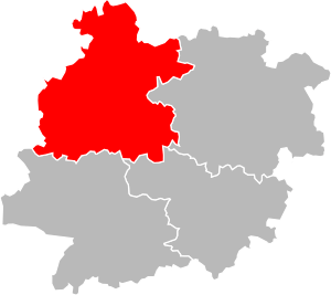
Location of Marmande in Lot-et-Garonne
|
|
| Country | France |
| Region | Nouvelle-Aquitaine |
| Department | Lot-et-Garonne |
| Communes | 98 |
| Subprefecture | Marmande |
| INSEE code | 472 |
| Area | |
| • Total | 1,387.7 km2 (535.8 sq mi) |
| Population
(2014)
|
|
| • Total | 83,245 |
| • Density | 59.9877/km2 (155.368/sq mi) |
The arrondissement of Marmande is a special kind of area in France. Think of it like a district or a county. It's part of the Lot-et-Garonne department, which is a larger administrative area. This department is located in the Nouvelle-Aquitaine region of France. The main town and administrative center of this arrondissement is the city of Marmande.
Contents
History of Marmande Arrondissement
The Lot-et-Garonne department was created a long time ago, on February 17, 1800. The arrondissement of Marmande was formed at the same time. It has been an important part of the department ever since.
Geography of Marmande Arrondissement
The Marmande arrondissement covers an area of about 1,387.7 square kilometers (535.8 square miles). In 2014, about 83,245 people lived here. This means there were about 60 people living in each square kilometer. This is called the population density.
This area is in the northwest part of the Lot-et-Garonne department. It shares borders with several other areas. To the north, it touches the Dordogne department. To the east, it borders the Villeneuve-sur-Lot arrondissement. The Agen arrondissement is to its southeast. To the south, it borders the Nérac arrondissement. Finally, to the west, it meets the Gironde department.
Towns and Villages in Marmande Arrondissement
An arrondissement is made up of smaller areas called communes. These are like towns or villages. The Marmande arrondissement has 98 communes in total.
Here are some of the communes in the arrondissement:
- Agmé (47002)
- Agnac (47003)
- Allemans-du-Dropt (47005)
- Antagnac (47010)
- Argenton (47013)
- Armillac (47014)
- Auriac-sur-Dropt (47018)
- Baleyssagues (47020)
- Beaupuy (47024)
- Birac-sur-Trec (47028)
- Bouglon (47034)
- Bourgougnague (47035)
- Brugnac (47042)
- Calonges (47046)
- Cambes (47047)
- Castelmoron-sur-Lot (47054)
- Castelnau-sur-Gupie (47056)
- Caubon-Saint-Sauveur (47059)
- Caumont-sur-Garonne (47061)
- Clairac (47065)
- Cocumont (47068)
- Coulx (47071)
- Couthures-sur-Garonne (47074)
- Duras (47086)
- Escassefort (47088)
- Esclottes (47089)
- Fauguerolles (47094)
- Fauillet (47095)
- Fourques-sur-Garonne (47101)
- Gaujac (47108)
- Gontaud-de-Nogaret (47110)
- Grateloup-Saint-Gayrand (47112)
- Grézet-Cavagnan (47114)
- Guérin (47115)
- Hautesvignes (47118)
- Jusix (47120)
- La Sauvetat-du-Dropt (47290)
- Labastide-Castel-Amouroux (47121)
- Labretonie (47122)
- Lachapelle (47126)
- Lafitte-sur-Lot (47127)
- Lagruère (47130)
- Lagupie (47131)
- Laparade (47135)
- Laperche (47136)
- Lauzun (47142)
- Lavergne (47144)
- Le Mas-d'Agenais (47159)
- Longueville (47150)
- Loubès-Bernac (47151)
- Lévignac-de-Guyenne (47147)
- Marcellus (47156)
- Marmande (47157)
- Mauvezin-sur-Gupie (47163)
- Meilhan-sur-Garonne (47165)
- Miramont-de-Guyenne (47168)
- Monteton (47187)
- Montignac-Toupinerie (47189)
- Montignac-de-Lauzun (47188)
- Montpouillan (47191)
- Moustier (47194)
- Pardaillan (47199)
- Peyrière (47204)
- Poussignac (47212)
- Puymiclan (47216)
- Puysserampion (47218)
- Romestaing (47224)
- Roumagne (47226)
- Ruffiac (47227)
- Saint-Astier (47229)
- Saint-Avit (47231)
- Saint-Barthélemy-d'Agenais (47232)
- Saint-Colomb-de-Lauzun (47235)
- Saint-Géraud (47245)
- Saint-Jean-de-Duras (47247)
- Saint-Martin-Petit (47257)
- Saint-Pardoux-Isaac (47264)
- Saint-Pardoux-du-Breuil (47263)
- Saint-Pierre-sur-Dropt (47271)
- Saint-Sauveur-de-Meilhan (47277)
- Saint-Sernin (47278)
- Sainte-Bazeille (47233)
- Sainte-Colombe-de-Duras (47236)
- Sainte-Gemme-Martaillac (47244)
- Sainte-Marthe (47253)
- Samazan (47285)
- Savignac-de-Duras (47294)
- Ségalas (47296)
- Sénestis (47298)
- Seyches (47301)
- Soumensac (47303)
- Taillebourg (47304)
- Tonneins (47310)
- Varès (47316)
- Verteuil-d'Agenais (47317)
- Villeneuve-de-Duras (47321)
- Villeton (47325)
- Virazeil (47326)
Largest Communes in Marmande Arrondissement
Here are the communes in the arrondissement with the most people living in them, based on 2014 numbers:
| INSEE code |
Commune | Population (2014) |
Main Canton | Intercommunality |
|---|---|---|---|---|
| 47157 | Marmande | 17,748 | Marmande-1 Marmande-2 |
Val de Garonne Agglomération |
| 47310 | Tonneins | 8,973 | Tonneins | Val de Garonne Agglomération |
| 47168 | Miramont-de-Guyenne | 3,184 | Le Val du Dropt | Le Pays de Lauzun |
| 47233 | Sainte-Bazeille | 3,143 | Marmande-1 | Val de Garonne Agglomération |
| 47065 | Clairac | 2,592 | Tonneins | Val de Garonne Agglomération |
| 47326 | Virazeil | 1,742 | Marmande-2 | Val de Garonne Agglomération |
| 47054 | Castelmoron-sur-Lot | 1,731 | Tonneins | Lot et Tolzac |
| 47110 | Gontaud-de-Nogaret | 1,670 | Marmande-2 | Val de Garonne Agglomération |
| 47024 | Beaupuy | 1,631 | Marmande-1 | Val de Garonne Agglomération |
Related pages
See also
 In Spanish: Distrito de Marmande para niños
 | William L. Dawson |
 | W. E. B. Du Bois |
 | Harry Belafonte |

