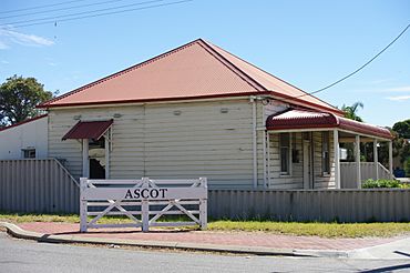
Ascot, Western Australia facts for kids
Quick facts for kids AscotPerth, Western Australia |
|||||||||||||||
|---|---|---|---|---|---|---|---|---|---|---|---|---|---|---|---|

Corner of Great Eastern Highway and Carbine Street
|
|||||||||||||||
| Established | 1991 | ||||||||||||||
| Postcode(s) | 6104 | ||||||||||||||
| Area | 3.7 km2 (1.4 sq mi) | ||||||||||||||
| Location | 10 km (6 mi) from Perth | ||||||||||||||
| LGA(s) | City of Belmont | ||||||||||||||
| State electorate(s) | Belmont | ||||||||||||||
| Federal Division(s) | Swan | ||||||||||||||
|
|||||||||||||||
Ascot is a suburb in Perth. It's a long, narrow piece of land right next to the Swan River. You can find it about 10 kilometres (6 mi) east of Perth's main city area. The local council that looks after Ascot is called the City of Belmont.
Ascot used to be part of other suburbs like Belmont and Redcliffe. But on March 7, 1991, it became its own official suburb. It was named after the famous Ascot Racecourse, which is a big horse-racing track located right there in Ascot!
Where is Ascot?
Ascot is a long, thin suburb, about 5 kilometres (3.1 mi) in length. It stretches along the southern bank of the Swan River. It starts near Abernethy Road in Belmont. It goes all the way to the border of the City of Belmont and the City of Swan near South Guildford.
Getting Around
You can get around Ascot and to other places using buses. Here are some of the bus routes that serve the area:
- Bus routes 290 and 291 travel along Great Eastern Highway. They connect Redcliffe Station to Midland Station.
- Bus route 293 also uses Great Eastern Highway. It goes from Redcliffe Station to High Wycombe Station.
- Bus route 940 is a frequent service on Great Eastern Highway. It connects Redcliffe Station to Elizabeth Quay Bus Station.
- The CircleRoute buses, 998 (clockwise) and 999 (anti-clockwise), have limited stops. They serve Grandstand Road and connect to Fremantle Station.
 | Valerie Thomas |
 | Frederick McKinley Jones |
 | George Edward Alcorn Jr. |
 | Thomas Mensah |

