
Bayswater, Western Australia facts for kids
Quick facts for kids BayswaterPerth, Western Australia |
|||||||||||||||
|---|---|---|---|---|---|---|---|---|---|---|---|---|---|---|---|

View of King William Street south from the Bayswater station shared path in January 2024
|
|||||||||||||||
| Established | 1885 | ||||||||||||||
| Postcode(s) | 6053 | ||||||||||||||
| Area | 9.83 km2 (3.8 sq mi) | ||||||||||||||
| Location | 6 km (4 mi) from Perth | ||||||||||||||
| LGA(s) | City of Bayswater | ||||||||||||||
| State electorate(s) | Maylands, Bassendean | ||||||||||||||
| Federal Division(s) | Perth | ||||||||||||||
|
|||||||||||||||
Bayswater is a suburb located about 6 kilometres (3.7 miles) north-east of Perth, the capital city of Western Australia. It sits just north of the Swan River. Bayswater is part of the City of Bayswater local government area. It's mostly a residential area with many single-family detached homes. You'll also find some shops and businesses, especially in the town centre around Whatley Crescent and King William Street. There's also a light industrial area in the eastern part of the suburb.
Before Europeans arrived, the Whadjuk Noongar people, specifically the Mooro group, lived here. In 1830, after the Swan River Colony was settled, land along the river was given to colonists. However, many left, and the area stayed undeveloped for most of the 1800s.
Things changed in 1881 when the Fremantle–Guildford railway line was built. This led to the creation of the Bayswater Estate, the first major development. In 1897, the Bayswater Road Board was formed, giving Bayswater its own local government. At first, Bayswater was known for nurseries, market gardens, and dairies. Over time, it grew into a busy suburban area. Today, Bayswater is fully developed, and older properties are often divided into smaller lots for new homes.
Bayswater has many great parks and wetlands, including the Baigup Wetlands, the Eric Singleton Bird Sanctuary, and Riverside Gardens. Other popular spots include Bert Wright Park, Halliday Park (with a war memorial), Hillcrest Reserve, and Houghton Park along the Swan River. Major roads like Guildford Road and Tonkin Highway connect Bayswater to other parts of Perth.
Contents
Bayswater's Past: A Journey Through Time
Early Days: Before European Settlement
Long ago, the land where Bayswater now stands was home to the Mooro group of the Whadjuk Noongar people. Their leader was Yellagonga. They lived north of the Swan River, stretching east to Ellen Brook and north to Moore River. The Swan River was very important to them, providing fresh water, food, and a place for trade. We know of a camping ground, over 4,500 years old, near where Tonkin Highway and Guildford Road meet today. Another camp was likely in the area now called the Baigup Wetlands.
European Settlers Arrive (1829-1880)
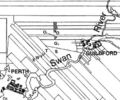
When Europeans started the Swan River Colony in 1829, they didn't recognise the Noongar people's ownership of the land. John Septimus Roe, the colony's surveyor, divided the land along the Swan River into long, narrow strips called "ribbon grants". These strips all had river access, which was important for transport back then. In 1830, colonists moved to their new land. But the Swan River flooded several times that year, ruining crops and homes. Many colonists either died or left the area soon after.
After being abandoned, the land was bought by others like Peter Broun and William Henry Drake. But they never lived on or improved the land. The last family to live there, the Drummonds, left in 1836. By 1833, a track connected Perth to Guildford, but it was sandy and hard to use. When The Causeway opened in 1836, a route south of the river became the main way to travel, and the northern track became less important. This track eventually became Guildford Road.
Between 1830 and 1880, only two houses are known to have been built in the area, but neither stands today. The oldest remaining sign of European settlement is an olive tree on Slade Street, believed to be planted in the 1840s. It was even used for religious services! This olive tree is now on the City of Bayswater's logo.
Bayswater Begins to Grow (1880s)
In 1881, the Fremantle–Guildford railway line was built. This made it much faster to travel from Bayswater to Perth or Guildford, taking only twenty minutes by train. This new railway opened up opportunities for developing the isolated land. Many people used the train to get close to the Perth Race Course. They would walk through the bush to the river, where boats would ferry them across. Around 1885, a footbridge was built over the river near the Eric Singleton Bird Sanctuary for racegoers.

In 1885, there was a "land boom" in Perth. William Henry Drake, who owned a large piece of land (Location U), had passed away. Joseph Rogers, a property developer from New South Wales, saw the land's potential and bought it. In July 1885, Rogers and his partner Feinberg, renamed the land the Bayswater Estate. They divided it into 5-acre (2-hectare) lots and put it up for sale. The suburb of Bayswater gets its name from this estate. A new road, named Coode Street north of the railway and King William Street south of it, was surveyed. A huge advertisement for the Bayswater Estate appeared in The Daily News on July 9, 1885.
People started buying the land. One buyer, Thomas Molloy, was upset when he found his land was far from the railway. He complained to the newspaper The West Australian. The newspaper then published an article criticising the land sale, which led to fewer people attending later auctions. Rogers and Feinberg sued the newspaper for defamation and won, but only received a tiny amount of money.
Because the land was divided into 5-acre lots instead of smaller town lots, Bayswater remained quite rural. Landowners used their plots for nurseries, dairies, and other farming activities. Houses were often built by the landowners themselves using simple materials like corrugated iron. In 1886, a branch railway line was built towards the river, near the Eric Singleton Bird Sanctuary. A footbridge was built later that year, so people didn't need ferries anymore.
During the late 1880s, more land was sold and divided. Many lots went to people from other states who were just speculating, but some buyers actually lived on their land. In 1887, Henry Walkenden started a brickworks in Bayswater, which was the first industrial site there. It employed up to 18 men. Remnants of this site, like Gobba Lake (which was a clay pit), still exist today.
New Services Arrive (1890s)
Residents of Bayswater wanted a school. Their first request in 1889 was denied, but a second, more organised effort in 1892 was successful. The Board of Education visited the area and agreed Bayswater needed a school. A one-room wooden building, Bayswater State School, opened in 1894 with 29 students. It quickly became too small. By 1896, some students had to stand because there wasn't enough space. The school was finally upgraded in 1900.
Another important goal for residents in the 1890s was to have their own road board. Bayswater was split between the Perth and Swan Road Districts, which made it hard to get roads built. After a second attempt, the Bayswater Road Board was officially formed on March 5, 1897. Both Perth and Swan Road Boards were happy to let Bayswater manage its own roads. A wooden hall for ratepayers was built on Guildford Road.
Bayswater gained many other services in the 1890s. A post office opened on King William Street in 1895. The railway line was doubled, and the Bayswater railway station was built in 1896. The railway became a big employer. In 1897, the branch line was extended across the river to the Perth Race Course. Churches were also established, including the first Baptist church in Western Australia.
More land was divided between 1895 and 1899. Roads were laid out in a grid pattern. Even with these new subdivisions, Bayswater wasn't very crowded. Land was cheap, so many people bought several lots for large gardens. Dairies, slaughterhouses, and market gardens were mixed in with houses. More brickyards and an ironworks opened in eastern Bayswater. By 1897, Bayswater's population was around 400. By the end of the decade, Bayswater was no longer isolated.
After Australia Became a Nation (Early 1900s)
After Australia became a federation in 1901, there were some disagreements between farmers and residents in Bayswater. People complained about cattle causing problems. But dairymen argued that cattle were important for the area. Piggeries received even more complaints because of their smell and noise. In 1903, the Bayswater Local Board of Health stopped piggeries from being built near the river and within 1 mile (1.6 km) north of the railway line. The road board also started controlling how land was divided, stopping very small blocks and narrow streets.

The opening of the Midland Railway Workshops in 1904 brought many new workers to the area, especially from other Australian states and Britain. By 1908, many Bayswater residents were from Victoria. Most buildings constructed after 1904 were made of bricks and weatherboard, designed to be more permanent. Many of these buildings are still standing today. The West Australian newspaper noted in 1909 that temporary shelters were gone, and most houses had a proper road connecting them to the railway station.
A group of shops and businesses grew along King William Street in the 1900s. In 1904, a company called Gold Estates of Australia bought the last large undeveloped land (Location V) and divided it into the Oakleigh Estate. This estate connected the two developed parts of Bayswater, making it one continuous settlement. By 1909, the population growth slowed down, but it continued to rise steadily. In 1909, the King William Street subway was built, allowing people to cross under the railway line safely. The 1911 census showed Bayswater's population was 1,758.
World War I stopped British migration, and Bayswater's growth slowed. Land values dropped. After the war, Bayswater's commercial centre expanded. By 1921, the population was 2,365.
In the mid-to-late 1920s, the Roads Board focused on improving Bayswater's facilities. They bought a market garden in the town centre to turn into a park, which became Whatley Gardens and later Bert Wright Park. New factories were built, including a large fertiliser factory that caused complaints about air pollution. This led to Bayswater's first town planning scheme, which aimed to keep industry in the eastern part of the suburb. This was one of the first town planning schemes in Western Australia.
During the 1930s, dairies in Bayswater slowly disappeared. New laws made it harder to set up dairies, and existing ones faced many complaints about noise and dust. In 1934, the first Garratt Road Bridge was built across the Swan River, connecting Bayswater and Ascot. In the late 1930s, the areas of Bayswater and Meltham Heights were officially named as townsites. People in Meltham Heights wanted a railway station, but it took a while to happen.

From 1942 to 1943, Bayswater became a key location for army signalling operations in Perth, in case of a Japanese invasion. Many homes and buildings were used by the military. A large aerial was put up where Hillcrest Primary School is today. New factories were built to supply military equipment.
After World War II: A Growing Community
After World War II, Bayswater's population grew very quickly. Many new houses were built. Development happened in Meltham Heights, and construction of Meltham station finally started in 1947, opening in 1949. A police station opened in Bayswater in 1954. The Belmont railway line closed in 1956 after a fire damaged its bridge over the Swan River.
With so many new families, a new primary school was needed. Hillcrest Primary School opened in 1950 with 120 students. Its buildings were expanded over the decade, and by 1958, it had about 700 students. Bayswater Primary School also had many students. In 1957, a fire destroyed the original 1894 building, forcing the government to build new and better facilities.
There was a plan to move railway marshalling yards (where trains are sorted) to Bayswater. Residents protested, and eventually, the plan was dropped. However, another report in 1955 suggested building two highways through Bayswater: Swan River Drive along the river and the Beechboro-Gosnells Highway (now Tonkin Highway). This caused frustration for landowners who couldn't build on their land zoned for these highways.
From 1961, the Swan River foreshore in Bayswater was used as a landfill for 17 years. The goal was to fill low-lying areas and create a park. Between the 1960s and 1980s, the names Meltham, Oakleigh Park, and Whatley disappeared as these areas became part of Bayswater.
In 1971–72, a second Garratt Road Bridge was built next to the 1934 bridge, creating two lanes in each direction. Both bridges are now heritage listed. In 1973, the shire opened Mertome Village, an aged care complex. This showed how local governments were starting to provide more social services. By the early 1970s, Bayswater was mostly developed. In the late 1970s, it was realised that the landfill by the river was bad for the environment, so it closed in 1980.
In the 1980s, the plans for Swan River Drive were cancelled, which made residents happy. The Beechboro-Gosnells Highway went ahead and opened in 1984, renamed Tonkin Highway. This highway helped reduce traffic in Bayswater.
Bayswater Today: The 21st Century
.JPG)
In the 2010s and 2020s, new developments in the Bayswater town centre and around Meltham station have been a big topic of discussion. The City of Bayswater started planning for the town centre in 2015, looking at building heights, land uses, and connections for people walking, cycling, and driving.
In 2019, DevelopmentWA (a government agency) began expanding a redevelopment area to include Bayswater and High Wycombe station. This area, called Metronet East, aims to guide development around the upgraded train stations. This means DevelopmentWA now has planning control for these areas, rather than the local council. Draft plans and design guidelines for the Bayswater section were released, allowing for buildings as tall as 15 stories in the town centre.
In 2019 and 2020, the City of Bayswater suggested creating a new suburb called Meltham in eastern Bayswater, named after the old Meltham Heights townsite. However, many residents were against it, so the plan was dropped in May 2020.
In February 2020, City of Bayswater councillors voted to protect the entire town centre as a heritage area. Some residents and groups worried this might stop new development, while others praised the move to protect Bayswater's history.
Bayswater's Location and Landscape


Bayswater is about 6 kilometres (3.7 miles) north-east of Perth's city centre. It's also about 15 kilometres (9.3 miles) east of the Indian Ocean. The suburb covers an area of 9.83 square kilometres (3.80 sq mi). The land ranges from 2 metres (6.6 ft) high along the Swan River to 45 metres (148 ft) at Hillcrest Primary School.
Bayswater is bordered by the Swan River to the south, with Ascot on the other side. To the west is Maylands, to the north are Bedford, Embleton, and Morley. To the east are Bassendean and Ashfield. Bayswater also touches corners with Inglewood and Eden Hill.
Most of Bayswater is made up of single-family homes. There's an industrial area in the east and a small town centre. The Tonkin Highway and the Midland railway line run through the suburb, dividing it.
The streets in Bayswater mostly follow a grid pattern. Some roads that run perpendicular to the Swan River are leftovers from the original "ribbon grants." Streets roughly parallel to the river came from later subdivisions. Many streets are named after early residents and landowners, like Whatley Crescent, Hamilton Street, Copley Street, and Drake Street. Other street names come from towns and streets in England, such as Almondbury Street or Shaftesbury Avenue.
Bayswater sits on the Bassendean Dunes, which are low hills made of white to grey sands. These sands don't hold nutrients well. Groundwater is about 10 metres (33 ft) below the surface. The Bassendean Dunes are part of the larger Swan Coastal Plain.
Bayswater Brook was a natural stream that flowed through Bayswater, connecting swamps and creeks. In the 1920s, it was changed into a network of drainage channels. The brook now flows into the Eric Singleton Bird Sanctuary, which then flows into the Swan River. The Eric Singleton Bird Sanctuary is an artificial wetland created after the area was used as a landfill. It had environmental problems until it was fixed up in 2015. Nearby is Gobba Lake, an artificial lake made from a clay pit used by Walkenden's Brickworks. Gobba Lake has also been improved to attract more plants and animals and for people to enjoy.
Erosion of the Swan River foreshore is a problem in Bayswater due to boat traffic. The City of Bayswater is working to prevent and fix this erosion.
Who Lives in Bayswater? (Demographics)

In 2021, Bayswater's population was 15,288 people. This number has been growing since 2001. In 2021, 48.9% of residents were male and 51.1% were female. The average age was 39, which is slightly older than the state and national average of 38. About 1.5% of residents identified as Aboriginal and Torres Strait Islander.
In 2021, Bayswater residents generally earned more money than the state average. The most common jobs were professionals (like doctors or teachers), managers, and office workers. Many residents worked in hospitals, state government, and mining.
The most common backgrounds for Bayswater residents in 2021 were English, Australian, Irish, Scottish, and Italian. About 64.8% of residents were born in Australia. Other common birthplaces included England, New Zealand, India, Vietnam, and Ireland. When it comes to religion, many residents said they had no religion (47.4%). Other common religions were Catholic (23.0%) and Anglican (7.8%). Churches in Bayswater include Saint Columba's Catholic Church, an Apostolic Church, and a Russian Orthodox Church, which is the only one in Perth.
Fun Places and Facilities in Bayswater

.JPG)
Bayswater has a small town centre around Whatley Crescent and King William Street. Here you'll find the Bayswater Library and Community Centre, a Bendigo Bank, a post office, a WA Police station, a hotel, and various small shops. Along Guildford Road, there are businesses like Muzz Buzz, Red Rooster, and car dealerships. In the industrial area to the east, you'll find a Bunnings Warehouse and the Baywaste Transfer Station. The closest big shopping centre is the Galleria in Morley.
Along the Swan River in Bayswater, there are many parks and reserves. The Baigup Wetlands are a large natural bushland area and an important home for birds. A. P. Hinds Reserve is where the ANA Rowing Club, Bayswater Paddlesports Club, and Bayswater Sea Scouts are located. Riverside Gardens is a popular park for dogs and picnics, with a playground, boat ramp, and a café. Events like the Autumn River Festival and the finish line of the Avon Descent are held here. Nearby is the historic Ellis House, which is now a community art centre. Next to Riverside Gardens is the Eric Singleton Bird Sanctuary, an artificial wetland and bird habitat. On the other side of Tonkin Highway is Claughton Reserve, a large park with a boat ramp and playground.
On the corner of Whatley Crescent and Garratt Road is the Frank Drago Reserve. This is home to the Bayswater City Soccer Club, Bayswater Bowls and Recreation Club, Bayswater Croquet Club, and Bayswater Tennis Club. In the town centre, you'll find Bert Wright Park, which hosts the Bayswater Growers' Market every Saturday. Halliday Park is home to the Bayswater Lacrosse Club and AIM Over 50 Archery Club, and it has a war memorial where an annual Anzac Day dawn service is held. Between Coode Street and Drake Street, near Hillcrest Primary School, is Hillcrest Reserve. This reserve has three ovals for Australian rules football and cricket, and is home to several sports clubs.
Learning in Bayswater: Schools

The first school in Bayswater was Bayswater Primary School, which opened in 1894 on Murray Street. As of 2020, it teaches about 60 Kindergarten students and 370 students from Pre-Primary to Year 6. It became an independent public school in 2020 and is listed on the City of Bayswater Local Heritage Survey. The school has a bell from a railway locomotive, given in 1904, which is still used to call students to class. This is why the school's motto is "Ringing True."
In 1936, St Columba's School, a private Catholic primary school on Roberts Street, opened. It teaches almost 500 students from Pre-Kindergarten to Year 6. The church on the school site is also listed on the City of Bayswater Local Heritage Survey.

The third school, and second public school, to open in Bayswater is Hillcrest Primary School, which started in 1950. Located on Bay View Street, it teaches about 61 Kindergarten students and 364 Pre-Primary to Year 6 students as of 2020. It also became an independent public school in 2020 and is listed on the City of Bayswater Local Heritage Survey.
In 1985, Durham Road School opened in Bayswater. This school helps students with intellectual and physical disabilities from Kindergarten to Year 12, serving students from all over Perth. In 2020, it had 200 students.
There are no high schools directly in Bayswater. However, parts of the suburb are in the intake areas for John Forrest Secondary College and Hampton Senior High School, both in Morley. Just north of Bayswater, in Bedford, is Chisholm Catholic College, a private Catholic high school.
How Bayswater is Governed
Local Government


Bayswater is part of the City of Bayswater local government area. Most of the suburb is in the City's west ward, with a small part in its central ward. Elections for councillors are held every two years in October. Between 1897 and 1983, Bayswater was the main office for the City of Bayswater, which was first known as the Bayswater Road Board. Different buildings have served as offices over the years, including the Bayswater Drill Hall and an office on Leake Street.
State Government
Bayswater is divided into two areas for the Western Australian Legislative Assembly (the state parliament). West of Tonkin Highway is in the Electoral district of Maylands, and east of Tonkin Highway is in the Electoral district of Bassendean. Both of these areas usually vote for the Labor Party. In the Western Australian Legislative Council (the upper house of state parliament), both districts are part of the East Metropolitan electoral region.
Federal Government
For the Australian Federal Government, Bayswater is in the Division of Perth. This area is also a strong supporter of the Australian Labor Party.
Getting Around Bayswater: Transport
Most people in Bayswater use cars to get to work. However, more people here use bicycles and public transport compared to the state average. About 15.6% of Bayswater residents take public transport to work, and 2.7% ride a bicycle.
Roads in Bayswater
Major roads in Bayswater include Tonkin Highway, Guildford Road, Beechboro Road North, Garratt Road, and Grand Promenade. Tonkin Highway runs north-south and connects to places like Ellenbrook and Joondalup to the north, and Perth Airport and Armadale to the south. The Mooro-Beeloo Bridge carries Tonkin Highway over the Swan River.
The only other bridge over the Swan River in Bayswater is Garratt Road Bridge, which connects to Ascot and Belmont. Guildford Road goes south-west to Maylands and the Perth city centre, and north-east to Bassendean, Guildford, and Midland. Grand Promenade heads north-west, connecting to other major roads. Beechboro Road North goes north to Beechboro and Malaga.
Local roads include Beechboro Road South, Collier Road, Coode Street, King William Street, Walter Road East, and Whatley Crescent. Whatley Crescent runs through the town centre and connects to Guildford Road. Collier Road links the industrial area to Tonkin Highway and Guildford Road.
King William Street is the main street in the town centre. King William Street and Coode Street connect through an underpass under the railway line. This underpass, known as the Bayswater Subway or Bayswater Bridge, was famous for being hit by tall vehicles until it was replaced by a taller bridge in 2023. There are three other railway crossings in Bayswater.
Train Travel


Bayswater and Meltham stations are located in Bayswater. These stations are served by Transperth's Airport line and Midland line trains. The Morley–Ellenbrook line is currently being built and will branch off east of Bayswater station. This new line will connect Bayswater to Perth's outer north-eastern suburbs. As part of this project, Morley station will be built just north of Bayswater, improving public transport for the northern parts of the suburb.
Bus Services
Transperth bus services in Bayswater include routes 40, 41, 45, 46, 341, 342, 955, 998, and 999. These buses are operated by Path Transit. Routes 40 and 41 go to the Perth city centre. Route 40 also connects to Morley bus station. Route 45 goes to Bassendean railway station. Route 46 travels north to Embleton. Routes 341 and 342 connect to Morley bus station and Bassendean railway station. Route 955 travels along Collier Road, connecting to Morley bus station and Ellenbrook. Routes 998 and 999, known as the CircleRoute, travel in a loop around Perth, connecting Bayswater to places like Morley bus station, Dianella Plaza, and Stirling railway station to the north, and Ascot Racecourse and Belmont Forum to the south.
Cycling in Bayswater

Bayswater has good connections for cyclists with shared paths. There's a Principal Shared Path (PSP) along the railway line, which goes to the Perth city centre and Midland. Tonkin Highway also has a PSP. There's a shared path along the river. In 2015, Leake and May Streets were chosen to become a "bike boulevard," meaning slower speed limits and traffic calming measures to make it safer for cyclists. This boulevard connects to the river, Bayswater Primary School, and the Perth–Midland PSP.
Images for kids
-
Ribbon grants near Swan River

