
Bedford, Western Australia facts for kids
Quick facts for kids BedfordPerth, Western Australia |
|||||||||||||||
|---|---|---|---|---|---|---|---|---|---|---|---|---|---|---|---|

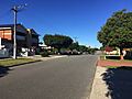
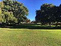
Rosebery Street near Park Street
|
|||||||||||||||
| Established | 1937 (townsite gazetted) | ||||||||||||||
| Postcode(s) | 6052 | ||||||||||||||
| Area | 2.33 km2 (0.9 sq mi) | ||||||||||||||
| Location | 6 km (4 mi) from Perth | ||||||||||||||
| LGA(s) | City of Bayswater | ||||||||||||||
| State electorate(s) | Maylands | ||||||||||||||
| Federal Division(s) | Perth | ||||||||||||||
|
|||||||||||||||
Bedford is a suburb located about 6 kilometers (4 miles) north-east of Perth, the capital city of Western Australia. It's named after Frederick Bedford, who was the Governor of Western Australia from 1903 to 1909. This area is part of the City of Bayswater local government area.
Bedford is mostly a residential area with many single-family detached homes. You'll find shops and businesses mainly along Beaufort Street, Grand Promenade, and Walter Road.
Long ago, the Mooro group of the Whadjuk Noongar people lived here. The suburb started growing in the 1920s when Beaufort Street was extended and a tram service began. Bedford Park officially became a townsite in 1937. After World War II, it grew much faster. Today, Bedford is a fully developed suburb.
Important roads in Bedford include Beaufort Street, Coode Street, Grand Promenade, and Walter Road. There are also several parks like Beaufort Park, RA Cook Reserve, and Grand Promenade Reserve. These parks are great for sports like Australian rules football, cricket, and soccer.
Contents
History of Bedford
First People of the Land
Before European settlers arrived, the land where Bedford now stands was home to the Mooro group. They were part of the Whadjuk Noongar people. Their leader was Yellagonga.
The Mooro people lived north of the Swan River. The river was very important to them. It provided fresh water and food. It was also a place where different groups could trade.
Early European Settlement
In 1829, European settlers started the Swan River Colony. They did not recognize that the land already belonged to the Noongar people. John Septimus Roe, the colony's main surveyor, mapped out the land along the Swan River.
He divided the land into long, narrow strips called "ribbon grants." Each strip had to reach the river. This was because the river was the only way to travel back then. Many early settlers found the inland areas too sandy or swampy for farming. Most of them left or did not stay long. No one settled in the Bedford area at this time, as it was far from the river.
Growing Up in the 20th Century
In the 1920s, Beaufort Street was extended into the area. The Beaufort Street tram line also reached Salisbury Street. A company called Gold Estates of Australia Pty Ltd bought land here. They divided it into blocks for houses.
This led to the first big developments in Bedford Park. Some of the houses built in the 1920s are still standing today. You can see them along Rosebery Street and Salisbury Street.

On June 18, 1937, Bedford Park officially became a townsite. It was named after Frederick Bedford, a former Governor. The townsite covered about 53 hectares (130 acres). It was centered around Beaufort Street and Grand Promenade.
During World War II, the tram line was extended to Grand Promenade. This was one of the last extensions to Perth's tram system.
After World War II, there was a big shortage of homes in Perth. The State Housing Commission bought large areas of land in Bedford. They built many new homes for people. The first public housing estate was built between Walter Road and Craven Street.
People praised the housing commission for building different-looking houses. Even though many homes were built, they didn't all look the same. This made the area feel more varied and interesting.
By 1948, more shops were needed for the growing population. The State Housing Commission decided to build shops along Grand Promenade. These were the first shops in Perth built with taxpayer money. By 1952, they were open. They included a butcher, chemist, grocer, and other stores.
The rapid growth put a strain on the local government's budget. They struggled to build enough roads. Eventually, an agreement was made for the State Housing Commission to help pay for half the road costs.
The growing number of families also meant a new primary school was needed. North Inglewood Primary School was too full. In 1950, a new school opened on Coode Street. It started with 120 students. The school expanded over the years. By 1958, it had about 700 students. The Catholic Church also opened St Peter's Primary School on Wood Street.
Starting in 1948, Perth's tramways began to close down. More people were using private cars. The Beaufort Street tramway was the last to close in 1958. It was replaced by trolleybuses. These buses followed similar routes.
In 1961, Bedford Park was officially renamed Bedford. The trolleybuses to Bedford closed in 1968. By the early 1970s, most of Bedford was fully developed.
Geography and Landscape

Bedford is about 6 kilometers (4 miles) north-east of Perth's city center. It is also about 13 kilometers (8 miles) east of the Indian Ocean. The suburb covers an area of about 2.33 square kilometers (0.9 square miles).
Bedford is surrounded by other suburbs. These include Morley to the north-east, Dianella to the north-west, and Inglewood to the south-west. Its borders follow the middle of Walter Road, Coode Street, York Street, and Salisbury Street.
The suburb is mostly made up of single-family homes. There are also groups of shops along Beaufort Street, Grand Promenade, and Walter Road. The streets in Bedford are laid out in a grid pattern. This is a leftover from the old "ribbon grants" land system.
Bedford sits on the Bassendean Dunes. These are low hills made of sandy soil. The sand is mostly white or grey. It doesn't hold nutrients very well. The Bassendean Dunes are part of the larger Swan Coastal Plain.
People of Bedford
In 2016, Bedford had a population of 5,438 people. This number has been growing steadily over the years. Slightly more than half of the residents are female. The average age in Bedford is 37 years old.
Most homes in Bedford are detached houses. Many people own their homes, either outright or with a mortgage. Some homes are rented.
The average weekly income for households in Bedford is higher than the average for Western Australia and the whole country. Many residents work in hospitals, cafes, restaurants, and government administration.
Most people living in Bedford were born in Australia. Other common birthplaces include England, New Zealand, India, Vietnam, and Italy. Many residents have parents who were born overseas. The most common religious beliefs are no religion, Catholic, and Anglican.
Parks and Fun Places

Bedford has small businesses along its main roads. For bigger shopping, residents usually go to Inglewood Coles nearby. Or they visit the Galleria Shopping Centre in Morley or Dianella Plaza.
- Beaufort Park: This park is on the corner of Drummond and Beaufort Streets. It has a big grass oval, a playground, and a hall you can hire. In summer, it's used for cricket. In winter, it has two soccer pitches.
- Grand Promenade Reserve: This park is also used for many sports. It has an oval for soccer and cricket. There are also cricket nets, courts for basketball and netball, and a playground. Next to it is a lawn bowls club.
- RA Cook Reserve: This sports reserve is on Coode Street. It's used for cricket, Australian rules football, hurling, and softball. It has several cricket pitches and nets. In winter, it has two Australian rules football ovals. Various sports clubs use this park.
There are also smaller parks throughout Bedford. These include Alan Lehmann Reserve, Birkett Street Reserve, Browns Lake Reserve, Gummery Reserve, and Remembrance Park.
Schools in Bedford


- St Peter's Primary School: This is a Catholic primary school on Wood Street. It has about 700 students from Kindergarten to Year 6. The school first opened in 1941 in a single house. It moved to its current site in 1942. Over the years, it has grown and been updated.
- Chisholm Catholic College: This is a Catholic high school for students from Year 7 to 12. It has about 1,700 students. It was formed in 1989 when two other schools, St Thomas Aquinas College and St Mark's College, merged. The school is now all on the Beaufort Street site.
Bedford does not have any public primary or secondary schools within its borders. However, parts of the suburb are in the school zones for Hillcrest Primary School, Inglewood Primary School, Morley Primary School, and John Forrest Secondary College.
How Bedford is Governed
Local Government
Bedford is part of the City of Bayswater local government area. It is located entirely within the City's west ward. The councillors for the west ward help make decisions for the local community.
State Government
Bedford is in the electoral district of Maylands. This area usually votes for the Labor Party. They have held this seat since 1968. The current member for Maylands is Lisa Baker. This district is also part of the East Metropolitan electoral region in the state parliament.
Federal Government
Bedford is part of the Division of Perth for the Australian Federal Government. This area is also a strong supporter of the Australian Labor Party. A Labor member has held this seat since 1983. The current member is Patrick Gorman.
Getting Around Bedford

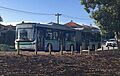
Most people in Bedford use cars to get to work or other places. However, many residents also use buses. Bus use in Bedford is higher than the average for Western Australia.
Roads
Major roads in Bedford include Beaufort Street, Coode Street, Grand Promenade, and Walter Road. Most of these roads have two lanes in each direction. The speed limit is usually 60 kilometers per hour (37 mph).
- Beaufort Street: This road connects Bedford to the Perth city center. It also leads to Morley and areas further east.
- Coode Street: This road links to the Bayswater town center and Guildford Road.
- Walter Road: This road connects Bedford to nearby suburbs.
- Grand Promenade: This road leads to Dianella Plaza and Morley Drive to the north-west. It also connects to Garratt Road to the south-east. Garratt Road crosses the Swan River over the Garratt Road Bridge.
Public Transport

Bedford is well-served by Transperth buses.
- Routes 66 and 950: These buses run along Beaufort Street. They travel between Morley bus station and the Perth city center. Route 950 continues to the University of Western Australia.
- Routes 998 and 999 (CircleRoute): These buses travel along Coode Street and Walter Road. They connect to Bayswater station and Dianella shopping center.
- Route 60: This bus travels along Walter Road, linking to Morley bus station and Elizabeth Quay bus station.
- Routes 67 and 68: These buses travel along Grand Promenade and Beaufort Street. They connect to Mirrabooka bus station and Perth Busport.
- Route 980: This bus runs along Walter Road between Morley bus station and Elizabeth Quay bus station.
Images for kids
-
Rosebery Street near Park Street
-
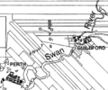
Map of ribbon grants near the Swan River
-
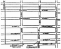
Bedford Park townsite map from 1937
-
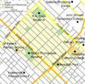
Map of Bedford and surrounding areas
-
Remembrance Park
-
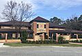
Chisholm Catholic College in July 2021
-
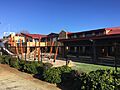
St Peter's Primary School in July 2021
-
Grand Promenade south of Walter Road
-
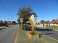
Transperth route 950 bus on Beaufort Street

