Ashland, Nebraska facts for kids
Quick facts for kids
Ashland, Nebraska
|
||
|---|---|---|

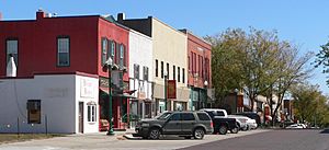
Downtown Ashland: Silver Street
|
||
|
||

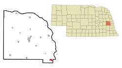
Location of Ashland, Nebraska
|
||
| Country | United States | |
| State | Nebraska | |
| County | Saunders | |
| Area | ||
| • Total | 1.41 sq mi (3.65 km2) | |
| • Land | 1.38 sq mi (3.58 km2) | |
| • Water | 0.03 sq mi (0.07 km2) | |
| Elevation | 1,093 ft (333 m) | |
| Population
(2020)
|
||
| • Total | 3,086 | |
| • Density | 2,231.38/sq mi (861.57/km2) | |
| Time zone | UTC-6 (Central (CST)) | |
| • Summer (DST) | UTC-5 (CDT) | |
| ZIP code |
68003
|
|
| Area code(s) | 402 | |
| FIPS code | 31-02305 | |
| GNIS feature ID | 2394000 | |
| Website | http://www.ashland-ne.com/ | |
Ashland is a city in Saunders County, Nebraska, United States. It's located between the larger cities of Omaha and Lincoln. In 2022, about 3,262 people lived there. Ashland is known for its history and its location near important travel routes.
Contents
History of Ashland
Ashland is built on a special spot where Salt Creek had a low, rocky bottom. This was important because Salt Creek was usually muddy and hard for wagons to cross. In the 1840s and 1850s, many people traveled west on trails like the Oregon Trail. A path called the Oxbow Trail, which was a part of the Oregon Trail, used this rocky crossing in Ashland. This made Ashland a key place for travelers to stop and cross the creek safely.
The city of Ashland was officially started in 1870. It was named after "Ashland," which was the home of a famous American statesman named Henry Clay. Today, Ashland is close to Interstate 80, a major highway. Its location near Omaha and Lincoln means it's growing, with more people choosing to live there while still enjoying a small-town feel.
Geography and Location
Ashland is a city in Nebraska. According to the United States Census Bureau, the city covers a total area of about 1.13 square miles (2.93 square kilometers). Most of this area is land, with a small part being water.
Ashland's Climate
Ashland experiences a climate with warm summers and cold winters. The hottest month is usually July, with average high temperatures around 87.2°F (30.7°C). The coldest month is January, with average low temperatures around 13.3°F (-10.4°C). The city gets a good amount of rain, especially in spring and summer. Snowfall is common in winter.
| Climate data for Ashland, Nebraska (1991–2020 normals, extremes 1893–2018) | |||||||||||||
|---|---|---|---|---|---|---|---|---|---|---|---|---|---|
| Month | Jan | Feb | Mar | Apr | May | Jun | Jul | Aug | Sep | Oct | Nov | Dec | Year |
| Record high °F (°C) | 72 (22) |
80 (27) |
91 (33) |
98 (37) |
107 (42) |
109 (43) |
116 (47) |
115 (46) |
108 (42) |
97 (36) |
85 (29) |
72 (22) |
116 (47) |
| Mean daily maximum °F (°C) | 32.7 (0.4) |
37.7 (3.2) |
50.6 (10.3) |
62.6 (17.0) |
73.3 (22.9) |
83.2 (28.4) |
87.2 (30.7) |
85.2 (29.6) |
78.5 (25.8) |
65.4 (18.6) |
49.8 (9.9) |
37.1 (2.8) |
61.9 (16.6) |
| Daily mean °F (°C) | 23.0 (−5.0) |
27.4 (−2.6) |
39.1 (3.9) |
50.4 (10.2) |
61.7 (16.5) |
72.3 (22.4) |
76.4 (24.7) |
74.1 (23.4) |
65.9 (18.8) |
53.2 (11.8) |
38.9 (3.8) |
27.7 (−2.4) |
50.8 (10.4) |
| Mean daily minimum °F (°C) | 13.3 (−10.4) |
17.0 (−8.3) |
27.6 (−2.4) |
38.2 (3.4) |
50.1 (10.1) |
61.5 (16.4) |
65.6 (18.7) |
63.0 (17.2) |
53.4 (11.9) |
40.9 (4.9) |
28.1 (−2.2) |
18.4 (−7.6) |
39.8 (4.3) |
| Record low °F (°C) | −33 (−36) |
−33 (−36) |
−21 (−29) |
3 (−16) |
24 (−4) |
35 (2) |
41 (5) |
38 (3) |
23 (−5) |
3 (−16) |
−15 (−26) |
−27 (−33) |
−33 (−36) |
| Average precipitation inches (mm) | 0.85 (22) |
0.98 (25) |
1.67 (42) |
3.18 (81) |
5.19 (132) |
4.48 (114) |
3.68 (93) |
3.96 (101) |
3.19 (81) |
2.40 (61) |
1.42 (36) |
1.29 (33) |
32.29 (820) |
| Average snowfall inches (cm) | 5.7 (14) |
6.2 (16) |
3.2 (8.1) |
0.9 (2.3) |
0.0 (0.0) |
0.0 (0.0) |
0.0 (0.0) |
0.0 (0.0) |
0.0 (0.0) |
0.6 (1.5) |
0.7 (1.8) |
4.8 (12) |
22.1 (56) |
| Average precipitation days (≥ 0.01 in) | 4.4 | 4.6 | 5.8 | 8.5 | 10.9 | 9.2 | 8.1 | 8.1 | 6.4 | 6.4 | 4.4 | 4.5 | 81.3 |
| Average snowy days (≥ 0.1 in) | 3.2 | 3.4 | 1.3 | 0.4 | 0.0 | 0.0 | 0.0 | 0.0 | 0.0 | 0.2 | 0.8 | 2.3 | 11.6 |
| Source: NOAA | |||||||||||||
Population of Ashland
Ashland has seen its population grow over the years. Here's how the number of people living in Ashland has changed over time:
| Historical population | |||
|---|---|---|---|
| Census | Pop. | %± | |
| 1870 | 653 | — | |
| 1880 | 978 | 49.8% | |
| 1890 | 1,601 | 63.7% | |
| 1900 | 1,477 | −7.7% | |
| 1910 | 1,379 | −6.6% | |
| 1920 | 1,725 | 25.1% | |
| 1930 | 1,786 | 3.5% | |
| 1940 | 1,709 | −4.3% | |
| 1950 | 1,713 | 0.2% | |
| 1960 | 1,989 | 16.1% | |
| 1970 | 2,176 | 9.4% | |
| 1980 | 2,274 | 4.5% | |
| 1990 | 2,136 | −6.1% | |
| 2000 | 2,262 | 5.9% | |
| 2010 | 2,453 | 8.4% | |
| 2020 | 3,086 | 25.8% | |
| U.S. Decennial Census | |||
What the 2010 Census Showed
In 2010, there were 2,453 people living in Ashland. Most of the people were White (97.6%). A small number of people were from other racial backgrounds. About 2.6% of the population identified as Hispanic or Latino.
The census also looked at households. About 34.8% of homes had children under 18 living there. Many homes (50.7%) were married couples. The average age of people in Ashland was 37 years old. About 26.1% of the residents were under 18, and 15.9% were 65 or older.
Local Businesses and Industries
Ashland has several businesses that provide jobs for people in the area. Some of the main employers include:
- Innovative Laboratory Systems
- Linoma Software
- Camp Ashland, which is a training center for the Nebraska Army National Guard
- Trade Well Pallet
Famous People from Ashland
Ashland is the hometown of some notable individuals:
- Clayton Anderson: He is an astronaut who has traveled to space.
- Jeff Raikes: He was the chief executive officer of the Bill & Melinda Gates Foundation, a very large charitable organization.
Additional Reading
- Saunders County History (1983)
- Andreas' History of the State of Nebraska
- Ashland Historical Society
See also
 In Spanish: Ashland (Nebraska) para niños
 | James Van Der Zee |
 | Alma Thomas |
 | Ellis Wilson |
 | Margaret Taylor-Burroughs |


