Assinica Lake facts for kids
Quick facts for kids Assinica Lake |
|
|---|---|

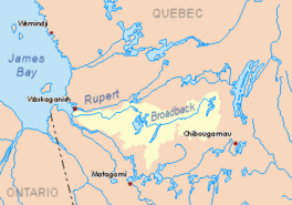
Watershed of Broadback River
|
|
| Location | Eeyou Istchee James Bay Regional Government |
| Coordinates | 50°31′28″N 75°13′26″W / 50.52444°N 75.22389°W |
| Type | Natural |
| Primary inflows |
|
| Primary outflows | Assinica Lake |
| Basin countries | Canada |
| Max. length | 20.6 kilometres (12.8 mi) |
| Max. width | 11.3 kilometres (7.0 mi) |
| Surface area | 93 kilometres (58 mi) |
| Surface elevation | 359 metres (1,178 ft) |
Assinica Lake is a large freshwater lake in Quebec, Canada. It's part of the Assinica River and Broadback River systems. You can find it in the Eeyou Istchee James Bay area.
Assinica Lake is one of many lakes that feed into the Assinica River. The main activities around the lake are forestry (cutting down trees for wood) and tourism (people visiting for fun).
The closest forest road is about 61 kilometers southeast of the lake. This road connects to a main highway, Route 113, and a railway. These links lead to towns like Chibougamau.
The lake's surface is usually frozen from early November until mid-May. It's generally safe to walk on the ice from mid-November to mid-April.
Contents
Exploring Assinica Lake's Geography
Assinica Lake is quite large, covering 93 square kilometers. It has a very interesting shape. You'll find many bays, peninsulas (land sticking out into the water), and about a hundred islands.
Lots of wetlands are located nearby. These wet areas are mostly on the east and west sides of the lake. Assinica Lake is connected to Caplan Lake on its south side.
There are also some hills nearby. Lookout Hill is to the south, reaching 459 meters high. Another peak in the southwest is even taller, at 513 meters. The lake has four big islands in its center. The longest of these islands is about 5.8 kilometers long.
Where Does Assinica Lake Flow?
The water from Assinica Lake flows out from its northwest side. This water forms the Assinica River. The Assinica River flows west, then north, and finally empties into the Broadback River.
Here are some distances from the lake's mouth:
- 25.6 km south of the Assinica River's mouth.
- 122.7 km east of the mouth of Evans Lake.
- 264.7 km east of the mouth of the Broadback River.
- 86.4 km west of Mistassini Lake.
- 95.2 km northwest of downtown Chibougamau.
Neighboring Waterways
The areas around Assinica Lake have many other lakes and rivers. Here are some of them:
- North side: Savournin Lake, Broadback River, Labeau Lake, Frotet Lake, Troilus Lake.
- East side: Cachisca Lake, Opataca Lake, Mistassini Lake.
- South side: Comencho Lake, Chibougamau River, Brock River West.
- West side: Lafargue Lake, Capichigamau Lake.
What's in a Name? The Meaning of "Assinica"
The name "Assinica" is used for the lake, the river, and a special wildlife reserve. The Commission de toponymie du Québec (Quebec's place-name commission) officially gave these names.
The word "Assinica" comes from the Cree language. It comes from "Asinikaw," which means "filled with stones."
Old maps show that before 1932, "Assinica" referred to a group of lakes in the same river system. Today, it only refers to this specific lake and its river. The name used to be spelled "Assinika."
The Assinica Wildlife Refuge surrounds the lake. This refuge is a huge protected area, covering 8,885 square kilometers.
The name lac Assinica was officially recognized on December 5, 1968, by the Commission de toponymie du Québec.
Images for kids
 | Victor J. Glover |
 | Yvonne Cagle |
 | Jeanette Epps |
 | Bernard A. Harris Jr. |


