Assinica River facts for kids
Quick facts for kids Assinica |
|
|---|---|

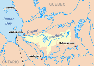
Watershed of Broadback River
|
|
| Country | Canada |
| Province | Quebec |
| Region | Nord-du-Québec |
| Physical characteristics | |
| Main source | Assinica Lake Nord-du-Québec, Eeyou Istchee Baie-James (municipality), Quebec 359 m (1,178 ft) 50°32′55″N 75°18′18″W / 50.54861°N 75.30500°W |
| River mouth | Broadback River Eeyou Istchee Baie-James (municipality), Nord-du-Québec, Quebec 291 m (955 ft) 50°42′36″N 75°33′24″W / 50.71000°N 75.55667°W |
| Length | 59.2 km (36.8 mi) |
| Basin features | |
| Tributaries |
|
The Assinica River is a river located in Quebec, Canada. It flows west and is a branch of the Broadback River, which eventually reaches Rupert Bay south of James Bay. The river is found in the Nord-du-Québec region, within the Eeyou Istchee Baie-James municipality.
The Assinica River starts from a group of lakes. These include Assinica, Comencho, Waposite, Cachisca, and Opataca. The main activities in this area are forestry, which means cutting down trees for wood, and outdoor tourism, like fishing or boating.
A forest road is located about 60.6 kilometres (37.7 mi) southeast of Assinica Lake. This road connects to Highway 113 and the Canadian National Railway. These connections help people get to and from the area.
The Assinica River is usually frozen from early November until mid-May. However, it's generally safe to travel on the ice from mid-November to mid-April.
Contents
The Assinica River's Journey
Surrounding Areas
The land around the Assinica River is made up of several important water areas. These are called hydrographic slopes.
- To the north: The Broadback River, Deriares Lake, and Camousichouane Lake.
- To the east: The Broadback River, Assinica Lake, Labeau Lake, Troïlus Lake, Frotet Lake, and Mistassini Lake.
- To the south: Assinica Lake, Comencho Lake, and Capichigamau Lake.
- To the west: Lucky Strike Creek, the Broadback River, Evans Lake, and the Nipukatasi River.
The River's Path
Assinica Lake is the starting point, or "head lake," of the Assinica River. It sits at an elevation of 359 metres (1,178 ft). The river begins flowing from the northwest side of this lake.
From there, the Assinica River flows for 59.2 kilometres (36.8 mi) through different sections:
- For 25.1 kilometres (15.6 mi), it flows west, passing through several rapids. It then crosses lakes Trépezet (at 342 metres (1,122 ft) high), Thiballier (at 339 metres (1,112 ft) high), and Boissy (at 319 metres (1,047 ft) high). Along this part, it collects water from Triat Lake, Chevardière Lake, and Lafargue Lake.
- Next, it flows 15.8 kilometres (9.8 mi) north, crossing an unnamed lake. It also gathers water from Sirmac Lake from the east.
- Then, it travels 5.9 kilometres (3.7 mi) west, going over more rapids, until it reaches Lucky Strike Creek.
- Finally, it flows 12.4 kilometres (7.7 mi) to the northeast, starting with more rapids, until it reaches its mouth.
Where the River Ends
The Assinica River joins the Broadback River on its south bank. This meeting point is in an area with many small islands.
This mouth is located:
- 98.6 kilometres (61.3 mi) east of the mouth of Evans Lake, which the Broadback River also flows through.
- 241.4 kilometres (150.0 mi) east of where the Broadback River meets Rupert Bay.
- 122.4 kilometres (76.1 mi) northwest of downtown Chibougamau.
- 108.6 kilometres (67.5 mi) west of Mistassini Lake.
- 24.5 kilometres (15.2 mi) northwest of Assinica Lake.
What Does "Assinica" Mean?
The name "Assinica" comes from the Cree language. In Cree, this word means "river filled with stones."
The official name 'rivière Assinica' was formally recognized on December 5, 1968, by the Commission de toponymie du Québec, which is Quebec's place-names board.
 | William L. Dawson |
 | W. E. B. Du Bois |
 | Harry Belafonte |

