Waposite Lake facts for kids
Quick facts for kids Waposite Lake |
|
|---|---|

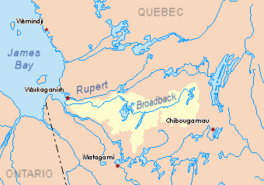
Watershed of Broadback River
|
|
| Location | Eeyou Istchee James Bay Regional Government |
| Coordinates | 50°15′40″N 75°14′27″W / 50.26111°N 75.24083°W |
| Type | Natural |
| Primary inflows | Outlet of “Trois Îles Lake” |
| Primary outflows | Comencho Lake |
| Basin countries | Canada |
| Max. length | 16.0 kilometres (9.9 mi) |
| Max. width | 6.2 kilometres (3.9 mi) |
| Surface elevation | 361 metres (1,184 ft) |
Waposite Lake is a beautiful lake located in the Broadback River area of Quebec, Canada. It's found in the Eeyou Istchee James Bay region, which is in the Nord-du-Québec part of the province. This lake is also part of the Assinica Wildlife Sanctuary.
The main activity around the lake is forestry, which means cutting down trees for wood. After that, people enjoy tourism and recreation, like visiting for fun.
To get close to the lake, there's a forest road about 35.6 kilometers (22 miles) southeast. This road goes around Mount Opémisca. It connects to Highway 113, which links the towns of Lebel-sur-Quévillon and Chibougamau. You can also find the Canadian National Railway nearby.
The surface of Waposite Lake is usually frozen solid from early November until mid-May. However, it's generally safe to walk or travel on the ice from mid-November to mid-April.
About Waposite Lake
Waposite Lake is quite large! It stretches for 16.0 kilometers (about 10 miles) in length. At its widest point, it measures 6.2 kilometers (about 3.8 miles) across. The lake sits high up, at an altitude of 361 meters (about 1,184 feet) above sea level.
The lake has several distinct parts:
- The western part gets water from Cachisca Lake to the northeast. Cachisca Lake has a dam at its exit. Water for Cachisca Lake comes from other lakes like Dumas Lake and Opataca Lake.
- The central part of Waposite Lake has many islands.
- The west part is shaped a bit like a square with rounded corners. It's about 3.2 kilometers (2 miles) long. A peninsula, which is a piece of land sticking out, separates it from the next part of the lake. This part of the lake has eight islands.
- The center-west part is 4.1 kilometers (2.5 miles) long. The center-east part is 6.2 kilometers (3.8 miles) from north to south and 4.0 kilometers (2.5 miles) wide. This section receives water from two smaller, unnamed lakes to the south.
- The eastern part is 5.2 kilometers (3.2 miles) from north to south and 4.1 kilometers (2.5 miles) wide. This section gets water from four lakes to the south, including "Lake of the Three Islands." A 2.0-kilometer (1.2-mile) peninsula separates "Lake of the Three Islands" from Waposite Lake.
Where the Water Flows
The water from Waposite Lake flows out into Comencho Lake. Here's how far Waposite Lake is from some other important places:
- 19.3 kilometers (12 miles) southeast of where Comencho Lake empties.
- 32.7 kilometers (20.3 miles) southeast of where Assinica Lake empties.
- 57.8 kilometers (35.9 miles) southeast of where the Assinica River joins the Broadback River.
- 149.4 kilometers (92.8 miles) east of where Evans Lake empties.
- 290.2 kilometers (180.3 miles) east of where the Broadback River flows into Rupert Bay.
- 66.6 kilometers (41.4 miles) northwest of downtown Chibougamau.
- 58.5 kilometers (36.4 miles) northwest of the village of Chapais, Quebec.
The main rivers and lakes that are close to Waposite Lake include:
- To the north: Comencho Lake, Assinica Lake, Assinica River, and Broadback River.
- To the east: Opataca Lake, Brock River West, and Brock River (Chibougamau River).
- To the south: Chibougamau River, des Orignaux Lake, and Deux Orignaux River.
- To the west: Naomi Creek, Omo River, Omo Lake, and Maicasagi River.
Name of the Lake
In the past, this lake was known by a different name: "Wasawapositeo Lake."
The official name "Lac Waposite" was formally chosen on December 5, 1968. This decision was made by the Commission de toponymie du Québec, which is the organization responsible for naming places in Quebec.
 | Roy Wilkins |
 | John Lewis |
 | Linda Carol Brown |


