Cachisca Lake facts for kids
Quick facts for kids Cachisca Lake |
|
|---|---|

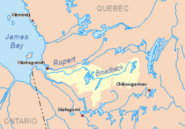
Watershed of Broadback River
|
|
| Location | Eeyou Istchee James Bay Regional Government |
| Coordinates | 50°28′03″N 74°59′57″W / 50.46750°N 74.99917°W |
| Type | Natural |
| Primary inflows | Outlet of Opataca Lake |
| Primary outflows | Comencho Lake |
| Basin countries | Canada |
| Max. length | 15.9 kilometres (9.9 mi) |
| Max. width | 6.2 kilometres (3.9 mi) |
| Surface area | 10 kilometres (6.2 mi) |
| Surface elevation | 361 metres (1,184 ft) |
Cachisca Lake is a beautiful lake located in the Quebec province of Canada. It's part of the Broadback River system. This lake is found in the Eeyou Istchee James Bay area, which is in the Nord-du-Québec region.
Cachisca Lake is also within the Assinica Wildlife Sanctuary. This means it's a protected area for animals and nature.
The main activity around the lake is forestry, which means cutting down trees for wood. After that, people enjoy visiting for fun activities like tourism.
A forest road is about 50.3 kilometres (31.3 mi) south-east of the lake. This road connects to Highway 113. Highway 113 links the towns of Lebel-sur-Quévillon and Chibougamau. There's also a Canadian National Railway nearby.
The lake usually freezes over from early November until mid-May. But it's safest to walk or play on the ice from mid-November to mid-April.
Contents
Exploring Cachisca Lake: Size and Location
Cachisca Lake is about 15.9 kilometres (9.9 mi) long. It has a maximum width of 6.2 kilometres (3.9 mi). The lake sits at an altitude of 350 metres (1,150 ft) above sea level.
The lake's shape is interesting! It gets narrower towards the north. But it spreads out more towards the south. In the southern part, you'll find many islands and peninsulas (pieces of land almost surrounded by water).
Cachisca Lake is nestled between two other lakes:
- Opataca Lake is to its east.
- Assinica Lake is to its west.
To the south of Cachisca Lake, there are mountains. Many of these mountain peaks are taller than 500 metres (1,600 ft). There are eleven tall peaks to the north and six to the west of the lake.
Where Does the Water Go?
The water from Cachisca Lake flows out into Comencho Lake. Here are some distances to important nearby places:
- It's about 8.8 kilometres (5.5 mi) east of where Comencho Lake's water flows out.
- It's about 20.6 kilometres (12.8 mi) south-east of where Assinica Lake's water flows out.
- It's about 45.9 kilometres (28.5 mi) south-east of where the Assinica River meets the Broadback River.
- It's about 142.6 kilometres (88.6 mi) east of Evans Lake.
- It's about 283 kilometres (176 mi) east of where the Broadback River meets Rupert Bay.
- It's about 76.3 kilometres (47.4 mi) north-west of downtown Chibougamau.
- It's about 73.5 kilometres (45.7 mi) north-west of the village of Chapais, Quebec.
Rivers and Lakes Nearby
Many rivers and lakes are connected to Cachisca Lake. Here are some of the main ones:
- North side: Frotet Lake, Regnault Lake, Chatillon River, Broadback River, Troilus Lake.
- East side: Opataca Lake, Brock River West, Brock River North, Chibougamau River, Mistassini Lake.
- South side: Comencho Lake, Waposite Lake, Chibougamau River, Brock River (Chibougamau River).
- West side: Naomi Creek, Omo River, Omo Lake, Maicasagi River.
What's in a Name? The Story of Cachisca Lake
Long ago, Cachisca Lake was called "Lake Capacwachipsca." In 1939, a group called the Quebec Geography Commission officially recognized this name.
The name "Capacwachipsca" comes from the Cree language. It's a shorter way of saying something that might mean "lake rock in shallow water." Imagine a lake with rocks that are easy to see because the water isn't very deep!
The name "Lac Cachisca" became official on December 5, 1968. This happened when the Commission de toponymie du Québec (Quebec Place Names Commission) was created. They are in charge of naming places in Quebec.
 | Tommie Smith |
 | Simone Manuel |
 | Shani Davis |
 | Simone Biles |
 | Alice Coachman |


