Comencho Lake facts for kids
Quick facts for kids Comencho Lake |
|
|---|---|

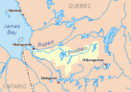
Watershed of Broadback River
|
|
| Location | Eeyou Istchee James Bay Regional Government |
| Coordinates | 50°21′32″N 75°09′08″W / 50.35889°N 75.15222°W |
| Type | Natural |
| Primary inflows |
|
| Primary outflows | Assinica Lake |
| Basin countries | Canada |
| Max. length | 26.3 kilometres (16.3 mi) |
| Max. width | 5.3 kilometres (3.3 mi) |
| Surface elevation | 358 metres (1,175 ft) |
Comencho Lake is a beautiful lake located in the Nord-du-Québec region of Quebec, Canada. It's part of the huge Broadback River system. This area is known as Eeyou Istchee James Bay.
The lake is also found within the Assinica Wildlife Sanctuary. This means it's a special place for nature and animals.
People in this area mostly work in forestry, which means managing forests. Tourism, like fishing and exploring, is also important here.
The closest main road is Quebec route 113, about 48.1 kilometres (29.9 mi) south of the lake. This road connects the towns of Lebel-sur-Quévillon and Chibougamau. There's also a train track nearby.
Comencho Lake usually freezes over in early November. It stays frozen until mid-May. It's generally safe to walk or travel on the ice from mid-November to mid-April.
Exploring Comencho Lake
Comencho Lake is quite large. It stretches for about 26.3 kilometres (16.3 mi) (that's over 16 miles!). At its widest point, it's about 5.3 kilometres (3.3 mi) across. The lake sits at an elevation of 358 metres (1,175 ft) above sea level.
The lake has three main sections:
- Northern Part: This area receives water from Cachisca Lake to the northeast. Water from other lakes like Dumas Lake and Opataca Lake also flows into this part.
- Central Part: This section is dotted with many islands. It's a great place to explore by boat.
- Southern Part: This part extends southeast into an area called the canton of Turgis. There's a large peninsula here with a mountain that reaches 461 metres (1,512 ft) high.
A long piece of land, about 6.4 kilometres (4.0 mi) long, separates Comencho Lake from Assinica Lake. This creates a narrow passage between the two lakes.
Where is Comencho Lake?
Comencho Lake is located:
- About 13.2 kilometres (8.2 mi) southeast of where Assinica Lake flows out.
- Around 38.5 kilometres (23.9 mi) southeast of the Assinica River's mouth. The Assinica River joins the Broadback River.
- About 84.0 kilometres (52.2 mi) northwest of the town of Chibougamau.
- Around 77.8 kilometres (48.3 mi) northwest of the village of Chapais, Quebec.
Rivers and Lakes Nearby
Many other rivers and lakes are close to Comencho Lake. They all connect to form a big water system.
- To the North: You'll find Assinica Lake, Assinica River, Broadback River, and Labeau Lake.
- To the East: There's Cachisca Lake, Opataca Lake, Brock North River, and Brock River (Chibougamau River).
- To the South: Look for Waposite Lake, Opataca Lake, Chibougamau River, Des Orignaux Lake, and Deux Orignaux River.
- To the West: You'll find the Monsan River, Capichigamau Lake, and Lucky Strike Creek.
What's in a Name?
The name "Comencho" likely comes from the Cree language. Its exact meaning isn't fully known. However, the name has changed over time. Older maps from 1931 show it as "Comenscocho" or "Comenscacho". By 1939, the name "Comencho" was commonly used.
Interestingly, the nearby Assinica Lake was once called "Comenscamoca". Many of these names share a root word, "men" or "min," which means "blueberries." For example, Caminscanane Lake, to the west, means "where there are many blueberries."
The name "Comencho Lake" was officially recognized on December 5, 1968. This was done by the Commission de toponymie du Québec, which is the official body for naming places in Quebec.
 | Percy Lavon Julian |
 | Katherine Johnson |
 | George Washington Carver |
 | Annie Easley |


