Assonet River facts for kids


The Assonet River is a river found in Bristol County, Massachusetts. It flows about 7.4 miles (11.9 km) west. The river goes through Freetown. It then joins the Taunton River near Assonet Neck in Berkley, Massachusetts.
Contents
Where Does the Assonet River Flow?
The Assonet River starts from the Cedar Swamp River. This is near the edge of Freetown and Lakeville. It begins just south of the village of Myricks. Quaker Brook joins the river at Forge Pond.
From there, the river flows next to Route 79. It passes through several small mill ponds. The river becomes tidal near the Elm Street Bridge in Assonet village. This means the water level changes with the ocean tides. Here, it gets wider and becomes Assonet Bay. This bay is west of Route 24.
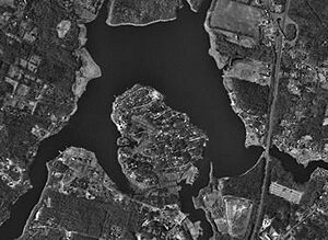
Assonet Bay has a few small coves. These coves are fed by small streams. Payne's Cove is one, fed by Terry Brook from the south. Shepherd's Cove is another, found at the bay's southwest end. Stacy's Creek also feeds the bay from the north. Small hills called drumlins surround Assonet Bay. After Shepherd's Cove, the Assonet River gets narrow again. It flows for its last mile before joining the wide Taunton River. This happens between Conspiracy Island and Winslow Point. This part of the river forms the border between Berkley and Freetown.
At its mouth, the Assonet River also forms Hathaway Cove in Assonet.
What is the History of the Assonet River?
The Assonet River is an important river in southeastern Massachusetts. It is like the Taunton River. For many years, during colonial and early American times, the river was very useful. Its water helped power grist mills, which ground grain. It also powered saw mills, which cut wood. Later, it powered the Crystal Springs Bleachery.
The river was also a small port for ships. It was a great place for herring fish to swim upstream.
The River During Wars
In the 1700s, the river played a part in the American Revolutionary War. British ships sailed on the Assonet and Taunton Rivers. They were fighting in the colonies. These attacks led to battles, like the Battle of Freetown. They also caused villages along the river to be burned.
In the 1800s, fishing and cargo ships often used the Assonet River. They sailed to their home port in Assonet, Massachusetts. From ports on Water Street and South Main Street, many goods were delivered. These included food, dairy products, lobster, fish, and lumber. For a time, guns were also made and shipped. The N. R. Davis Gun Factory was on Water Street, next to the river. It made many weapons for soldiers in the Civil War.
The River in the 20th Century
The river continued to be active in the 1900s, but only for a short time. The last ship to leave Assonet sailed in 1902. Some secret operations used the river to bring in illegal goods. This was called bootlegging.
The Green Dragon Tavern was taken down in the 1930s. The Town of Freetown then built its bandstand on the riverside. This created a nice green area. The gun factory burned down in 1925. The bleachery also burned in 1955. These events mostly ended the river's commercial use.
Assonet Bay Shores is a part of the area. It used to be a summer community. It is a piece of land surrounded by Assonet Bay, Payne Cove, and Shepherd's Cove. People first settled here early in Assonet's history. A big development happened in the early 1960s. Across Shepherd's Cove, there are many nice homes. This shows that the river has become a beautiful place for people to live.
 | Jewel Prestage |
 | Ella Baker |
 | Fannie Lou Hamer |


