
Assonet, Massachusetts facts for kids
Quick facts for kids
Assonet
|
|
|---|---|
|
Town of Freetown
|
|

Assonet Bandstand
|
|

Location of Assonet in Massachusetts.
|
|
| Country | United States |
| State | Massachusetts |
| County | Bristol County |
| Town | Freetown |
| Settled | 1659 |
| Population
(2000)
|
|
| • Total | 4,084 |
| Time zone | UTC−5 (Eastern Standard) |
| • Summer (DST) | UTC−4 (Eastern Daylight) |
| ZIP Code |
02702
|
| Area code(s) | 508 |
Assonet (pronounced uh-SOH-nit) is one of two villages in the town of Freetown. It is located in Bristol County, Massachusetts, United States. Assonet was settled in 1659, at the same time as the city of Fall River, which was then part of Freetown. The village sits along the Assonet River. In 2000, Assonet had about 4,084 people. By 2014, the estimated population grew to 9,093.
Contents
History of Assonet
Assonet was first settled in 1659. This happened soon after a land deal called "Ye Freemen's Purchase" was completed. It was part of the Plymouth Colony until 1691. That's when it joined with the Massachusetts Bay Colony.
What Does "Assonet" Mean?
The name "Assonet" comes from the local Wampanoag Native Americans. They had a settlement in this area. The word has two traditional meanings: "place of rocks" and "song of praise." The first meaning, "place of rocks," comes from the Algonquian language. Hassun or assin means "stone," and -et means "at the place of." So, it means "at the place of the stone."
Early Settlement and Growth
The entire region was sold to English settlers in 1659 by the Wampanoag people. However, wars between the English and Native Americans, like King Philip's War, slowed down permanent settlement. By 1683, Assonet and Fall River became the Town of Freetown. It was named Freetown because its first settlers were "Freemen."
For many years, Assonet was a small village known for fishing and farming. By the late 1700s, it became Freetown's busiest area for industry. However, by the end of the 1800s, its industries started to slow down. In the early 2000s, the village began to grow quickly again.
Assonet in the 18th Century
In the 1700s, Assonet became an important fishing port in Southeastern Massachusetts. It was especially known for its trout. Industries like grist mills (for grinding grain), sawmills (for cutting wood), and blacksmith shops also started here.
During the Revolutionary War, some small fights happened in Assonet. The Battle of Freetown was fought nearby. Some people in the main part of the village supported the British during the war. Many old houses with white chimneys and black rings show they supported the British. As the 1700s ended, churches and other important buildings, like the Village School (built in 1794), appeared in Assonet.
Assonet in the 19th Century

The 1800s were a very busy time for industries in Assonet. The village grew fast because of its railroads, ships, and its location on mail and stagecoach routes. It also had many factories.
Today's Route 79 generally follows the old mail and stagecoach route from Rhode Island to Boston. The Green Dragon Tavern on South Main Street was a popular stop. The downtown area was busy with shipbuilding and was a port for importing and exporting goods. It also had a successful fishing industry.

The N. R. Davis Gun Manufactory opened in Assonet. It made many weapons for soldiers during the Civil War. The Crystal Springs Bleachery and Dying Company also opened. This brought mill housing to the village and gave jobs to many people.
Important buildings like North Church (1809), Town Hall (1888), and the Guilford H. Hathaway Library (1895) were all built close together. The Town Hall has been used for town offices, meetings, and even a police station. The Guilford Hathaway Library was the town's only library until 1947.
The first Post Office in Assonet opened in 1811 and has been running ever since. The ZIP Code for Assonet is 02702.
Assonet in the 20th Century
.jpg)
In the mid-1900s, Assonet's industries started to decline. Most of its mills closed after Second World War. The N. R. Davis Gun Factory burned down in 1925. The Crystal Springs Bleachery also burned in 1955. After the war, most villagers found jobs outside of town, and farming became common again. However, this trend didn't last long. By the 1990s, the village started to grow again. Many people from Boston moved here, seeing it as a nice place to live.
The local Verizon station in Assonet was one of the first places to use regional dialing systems. The Freetown Fire Department Company 1 was built nearby in 1948.
Assonet in the 21st Century
The Stop & Shop Supermarket Company opened a very large distribution center near the old Crystal Springs Bleachery site. This center created over 800 jobs in the area. Parts of the village have been recognized for their historical importance and added to the National Register of Historic Places.
Assonet Historic District
|
Assonet Historic District
|
|

Town Hall (1888), Village School (1794), and North Church (1809)
|
|
| Location | Freetown, Massachusetts |
|---|---|
| Architect | Pierce, Ebenezer; Marble, Charles C. |
| Architectural style | Colonial, Georgian |
| NRHP reference No. | 99001116 |
| Added to NRHP | September 9, 1999 |
The Assonet Historic District was added to the National Register of Historic Places in 1999. This area includes many buildings that are important to local and national history. For example, it has the home of United States Secretary of State John Hay's grandfather.
Important Buildings in the Historic District
- Assonet Burying Ground (around 1800)
- Col. Thomas Gilbert House (around 1700)
- Freetown Town Hall (1888)
- Guilford H. Hathaway Library (1895)
- North Church (1809) (now the United Church of Assonet)
- South Church (around 1835) (now St. Bernard's Church)
- Village School (1794)
Churches in Assonet
Assonet has a history of different Christian churches. Several Quaker meetinghouses were also active in the 1600s and 1700s.
South Church
South Church was built in 1795 and rebuilt in 1835 after a lightning strike. It served as the First Christian Church of Assonet for many years. In 1968, it joined with the Congregational Church to form the United Church of Assonet. South Church was later sold in 1979. Baptisms used to take place in the Assonet River.
North Church
North Church (1809) was the Congregational Church. In 1968, it joined with the First Christian Church to form the United Church of Assonet. This church is still used today. The bell in its steeple was made by Paul Revere. North Church is now part of the United Church of Christ.
St. Bernard's Church

Roman Catholics in Assonet first had a mission in 1912. Services were held in private homes until 1937. That's when St. Bernard's Catholic Church was built. As the number of people grew, the church moved to the larger South Church building, which was renovated and renamed St. Bernard's Church. The original St. Bernard's building was sold in 1981 and has been used for different businesses since then.
Assonet is part of the Roman Catholic Diocese of Fall River.
Schools in Assonet
From the early 1800s until 1950, Freetown had several small neighborhood schools. At least three of these were in Assonet.
South School
South School was open from 1869 to 1950. It was a three-room schoolhouse for grades 1–8, and later for grades 3–6. There was one teacher for every two grades. The building is still there today, but it is empty.
Village School
Village School closed in 1950. It is located between the Town Hall and North Church. It started as a lawyer's office in 1794, then became a school. In the 1850s, it was a private school called the Assonet Academy. The town bought it around 1903 and used it as a grammar school until 1950. In the 1940s, grades 1-2 were in one room and grades 7-8 in another. The school had wood-burning stoves for heat. Today, the Town Hall uses it for storage. Efforts are being made to restore this old building.
Forge School
The Forge School closed in 1940. It was used for grades 7 and 8. The schoolhouse was later turned into a house, which burned down in 2002. It has since been rebuilt.
Schools Today
Since 1950, students have attended the Freetown Elementary School for younger grades. Then they go to the George R. Austin Intermediate School for grades 4-5. For grades 6-8, students attend Freetown-Lakeville Middle School.
For high school, students have a few choices:
- Apponequet Regional High School is for students who want to focus on academics.
- Old Colony Regional Vocational Technical High School in Rochester offers vocational and technical training.
- Bristol County Agricultural High School is for students interested in farming and animal studies.
There are also several Catholic high schools in the area.
Geography of Assonet

Assonet is located in Southeastern Massachusetts. It is next to Fall River, Berkley, Lakeville, East Freetown, and the Assonet River. The land is hilly with many rock formations. One famous rock is Profile Rock, which is said to look like the profile of the Wampanoag Indian chief Massasoit. You can find maple, elm, oak, pine, and birch trees here. Many streams and brooks flow through the village, as does the Assonet River.
Important bodies of water include Assonet Bay and Mill Pond. Bryant's Neck, also called Assonet Bay Shores, is a large piece of land that sticks out into Assonet Bay. This area is known for its salt marshes. The area around Mill Pond is a popular spot for herring runs.
A large part of the village is also within the Freetown-Fall River State Forest.
Images for kids
-
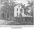
Col. Thomas Gilbert House
-
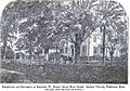
Ebenezer Peirce Estate (torn down in 1938)


