Atmore, Alberta facts for kids
Quick facts for kids
Atmore
|
|
|---|---|
|
Hamlet
|
|

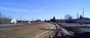
Highway 55 through the community
|
|
| Country | Canada |
| Province | Alberta |
| Region | Northern Alberta |
| Census division | 13 |
| Municipal district | Athabasca County |
| Area
(2021)
|
|
| • Land | 0.54 km2 (0.21 sq mi) |
| Population
(2021)
|
|
| • Total | 10 |
| • Density | 18.5/km2 (48/sq mi) |
| Time zone | UTC-7 (MST) |
| • Summer (DST) | UTC-6 (MDT) |
Atmore is a small community, often called a hamlet, located in Alberta, Canada. It's a quiet spot within Athabasca County. You can find Atmore about 1 kilometer (0.6 miles) east of where Highway 55 and Highway 63 meet.
This hamlet is situated on the southwestern shore of Charron Lake. It sits at an elevation of about 585 meters (1,919 feet) above sea level. Atmore is about 43 kilometers (27 miles) west of Lac La Biche and 54 kilometers (34 miles) east of Athabasca. If you travel south from Fort McMurray for about 250 kilometers (155 miles), you'll reach Atmore.
Discover Atmore's Population
How Many People Live Here?
Every few years, Statistics Canada conducts a count of people, called a census. This helps us understand how many people live in different places.
In the 2021 Census, Atmore had a population of 10 people. These residents lived in 8 of the 12 homes available in the hamlet. This number was a change from its 2016 population of 35 people.
Population Changes Over Time
During the 2016 Census, Atmore had 35 residents. They lived in 14 out of 16 total private homes. This number was also a change from its 2011 population, which was 20 people.
Atmore covers a land area of about 0.54 square kilometers (0.21 square miles). In 2021, this meant there were about 18.5 people living per square kilometer. In 2016, the population density was higher, with about 64.8 people per square kilometer.
 | James Van Der Zee |
 | Alma Thomas |
 | Ellis Wilson |
 | Margaret Taylor-Burroughs |


