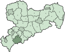
Aue-Schwarzenberg was a special area, like a county, in the German state of Saxony. It was a district until 2008.
History of Aue-Schwarzenberg
This district was created by joining two older districts, Aue and Schwarzenberg. They first formed in 1873. In 1994, these two areas became one new district. It was first called Westerzgebirgskreis, which means 'Western Ore Mountains District'. A year later, in 1995, its name was changed to Aue-Schwarzenberg.
Geography of the District
Aue-Schwarzenberg was located in the western part of the Erzgebirge Mountains. These mountains are also known as the Ore Mountains. The very top of these mountains forms the border between Germany and the Czech Republic. The tallest point in the district was a mountain called Auersberg. It stands 1,019 meters (3,343 feet) high. It is the second highest mountain in all of Saxony.
Coat of Arms
 |
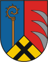
The coat of arms shows three main symbols:
- The bishop's crook stands for the old monastery of Grünhain. This was the oldest settlement in that part of the mountains.
- The wolf's teeth were part of the coat of arms for the county of Schwarzenberg.
- The black cross on a yellow background was used by the county of Hartenstein. This county owned the northern parts of the district.
|
Towns and Municipalities
| Towns |
Municipalities |
|
- Aue
- Eibenstock
- Grünhain-Beierfeld
- Johanngeorgenstadt
- Lauter
- Lößnitz
- Schneeberg
- Schwarzenberg
|
- Bad Schlema
- Bernsbach
- Bockau
- Breitenbrunn
- Raschau-Markersbach
|
- Schönheide
- Sosa
- Stützengrün
- Zschorlau
|
See Also
- Free Republic of Schwarzenberg


