Baker, Montana facts for kids
Quick facts for kids
Baker
|
|
|---|---|

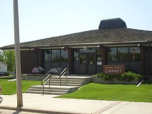
Fallon County Library
|
|
| Nickname(s):
"Friendly City"
|
|

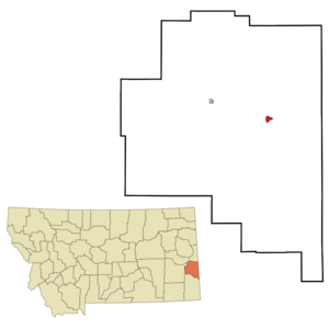
Location of Baker, Montana
|
|
| Country | United States |
| State | Montana |
| County | Fallon |
| Area | |
| • Total | 1.23 sq mi (3.18 km2) |
| • Land | 1.13 sq mi (2.93 km2) |
| • Water | 0.10 sq mi (0.26 km2) |
| Elevation | 2,940 ft (900 m) |
| Population
(2020)
|
|
| • Total | 1,802 |
| • Density | 1,594.69/sq mi (615.96/km2) |
| Time zone | UTC-7 (Mountain (MST)) |
| • Summer (DST) | UTC-6 (MDT) |
| ZIP codes |
59313, 59354
|
| Area code(s) | 406 |
| FIPS code | 30-03475 |
| GNIS feature ID | 2409772 |
Baker is a city in Montana, United States. It is the main town, or county seat, of Fallon County. In 2020, about 1,802 people lived there.
The city was named after A. G. Baker. He was an engineer who worked for the Chicago, Milwaukee, St. Paul and Pacific Railroad.
Contents
History of Baker
Baker started as a town along the transcontinental railway line. This was the Milwaukee Road, a big train company. They built a lake nearby to get water for their steam locomotives.
For a short time, the city was called Lorraine. But then it was renamed Baker, honoring engineer A.G. Baker. The Milwaukee Land Company helped many people move to the area. This helped Baker grow as a place for dryland farmers.
In 1912, oil and natural gas were found nearby. This discovery helped the city grow even more. By 2014, Baker was a busy place because of the oil fields.
On June 11, 2016, a strong tornado hit Baker. It damaged many homes and injured six people.
Geography and Nature
Baker is located in eastern Montana. U.S. Route 12 goes right through the town.
The city covers about 1.07 square miles (2.77 square kilometers). Most of this area is land.
The land around Baker has a lot of Sandstone rock. You can see many cool sandstone shapes at nearby Medicine Rocks State Park.
Baker's Climate
Baker has a cold semi-arid climate. This means it's often dry and can have very cold winters. The hottest temperature ever recorded in Baker was 108°F (42°C). This happened on July 23, 2007, June 26, 2012, and August 12, 2018. The coldest temperature was -34°F (-37°C) on February 14, 2021.
| Climate data for Baker, Montana (Baker Municipal Airport), 1991–2020 normals, extremes 1998–present | |||||||||||||
|---|---|---|---|---|---|---|---|---|---|---|---|---|---|
| Month | Jan | Feb | Mar | Apr | May | Jun | Jul | Aug | Sep | Oct | Nov | Dec | Year |
| Record high °F (°C) | 61 (16) |
68 (20) |
82 (28) |
93 (34) |
94 (34) |
108 (42) |
108 (42) |
108 (42) |
101 (38) |
91 (33) |
80 (27) |
70 (21) |
108 (42) |
| Mean maximum °F (°C) | 50.0 (10.0) |
50.7 (10.4) |
68.1 (20.1) |
77.7 (25.4) |
83.6 (28.7) |
92.8 (33.8) |
99.6 (37.6) |
98.6 (37.0) |
93.4 (34.1) |
79.9 (26.6) |
67.7 (19.8) |
52.5 (11.4) |
101.4 (38.6) |
| Mean daily maximum °F (°C) | 28.3 (−2.1) |
31.4 (−0.3) |
43.0 (6.1) |
54.7 (12.6) |
65.3 (18.5) |
75.8 (24.3) |
85.4 (29.7) |
84.6 (29.2) |
73.3 (22.9) |
56.6 (13.7) |
42.0 (5.6) |
31.2 (−0.4) |
56.0 (13.3) |
| Daily mean °F (°C) | 17.7 (−7.9) |
20.9 (−6.2) |
31.6 (−0.2) |
42.3 (5.7) |
52.6 (11.4) |
62.8 (17.1) |
70.7 (21.5) |
69.1 (20.6) |
58.6 (14.8) |
43.8 (6.6) |
30.8 (−0.7) |
20.7 (−6.3) |
43.5 (6.4) |
| Mean daily minimum °F (°C) | 7.0 (−13.9) |
10.3 (−12.1) |
20.2 (−6.6) |
29.9 (−1.2) |
40.0 (4.4) |
49.9 (9.9) |
56.1 (13.4) |
53.7 (12.1) |
44.0 (6.7) |
31.1 (−0.5) |
19.5 (−6.9) |
10.2 (−12.1) |
31.0 (−0.6) |
| Mean minimum °F (°C) | −18.6 (−28.1) |
−16.7 (−27.1) |
−3.1 (−19.5) |
12.5 (−10.8) |
26.5 (−3.1) |
39.1 (3.9) |
46.5 (8.1) |
41.7 (5.4) |
30.7 (−0.7) |
13.9 (−10.1) |
−3.2 (−19.6) |
−16.7 (−27.1) |
−26.8 (−32.7) |
| Record low °F (°C) | −31 (−35) |
−34 (−37) |
−28 (−33) |
−5 (−21) |
15 (−9) |
30 (−1) |
41 (5) |
36 (2) |
22 (−6) |
−4 (−20) |
−17 (−27) |
−33 (−36) |
−34 (−37) |
| Average precipitation inches (mm) | 0.22 (5.6) |
0.25 (6.4) |
0.53 (13) |
1.35 (34) |
2.66 (68) |
2.81 (71) |
2.03 (52) |
1.49 (38) |
1.53 (39) |
1.10 (28) |
0.43 (11) |
0.18 (4.6) |
14.58 (370.6) |
| Average snowfall inches (cm) | 5.8 (15) |
5.8 (15) |
5.3 (13) |
3.6 (9.1) |
1.1 (2.8) |
0.0 (0.0) |
0.0 (0.0) |
0.0 (0.0) |
0.0 (0.0) |
1.2 (3.0) |
1.8 (4.6) |
4.8 (12) |
29.4 (74.5) |
| Average precipitation days (≥ 0.01 in) | 3.4 | 5.1 | 5.6 | 8.2 | 12.3 | 12.2 | 8.6 | 8.1 | 8.0 | 8.2 | 4.4 | 3.7 | 87.8 |
| Average snowy days (≥ 0.1 in) | 2.9 | 3.8 | 2.3 | 0.9 | 0.4 | 0.0 | 0.0 | 0.0 | 0.0 | 0.5 | 1.3 | 2.7 | 14.8 |
| Source 1: NOAA | |||||||||||||
| Source 2: National Weather Service (mean maxima and minima 2006–2020) | |||||||||||||
People of Baker
| Historical population | |||
|---|---|---|---|
| Census | Pop. | %± | |
| 1920 | 1,067 | — | |
| 1930 | 1,212 | 13.6% | |
| 1940 | 1,304 | 7.6% | |
| 1950 | 1,772 | 35.9% | |
| 1960 | 2,365 | 33.5% | |
| 1970 | 2,584 | 9.3% | |
| 1980 | 2,354 | −8.9% | |
| 1990 | 1,818 | −22.8% | |
| 2000 | 1,695 | −6.8% | |
| 2010 | 1,741 | 2.7% | |
| 2020 | 1,802 | 3.5% | |
| U.S. Decennial Census | |||
In 2010, there were 1,741 people living in Baker. Most people were White (97.5%). A small number were Native American or Asian. About 1.3% of the population was Hispanic or Latino.
The average age in Baker was about 39 years old. About 23% of the people were under 18. And about 17% were 65 or older.
Arts and Culture
The O'Fallon Historical Museum is in Baker. It has many interesting things to see, including the world's largest steer.
The Fallon County Library serves the people of Baker. It's a great place to find books and learn new things.
Education in Baker
Baker Public Schools teach students from kindergarten all the way to 12th grade. Baker High School has about 140 students.
The school's mascot is the 'Spartan'. The Baker Spartans football team has won 6 State Football Championships! This was under their long-time coach, Don Schillinger.
Local Media
Baker has its own local newspaper called the Fallon County Times. It comes out every week.
There are also two radio stations in Baker:
- KFLN AM plays country music.
- KJJM FM plays classic rock music.
Transportation and Roads
U.S. Route 12 goes through Baker from east to west. Montana Highway 7 runs north to south through the town.
The Baker Municipal Airport is a small airport. It is located about 1 mile (1.6 km) southeast of the center of Baker.
Famous People from Baker
Some notable people have connections to Baker:
- Bill Bowman – A state senator from North Dakota.
- Irene Lentz – A famous Hollywood costume designer.
- Tyler Lyson – A paleontologist who studied at Baker High School.
- Shann Schillinger – An NFL player for the Atlanta Falcons.
- Jack Westrope – A Hall of Fame jockey.
See also
 In Spanish: Baker (Montana) para niños
 | Delilah Pierce |
 | Gordon Parks |
 | Augusta Savage |
 | Charles Ethan Porter |

