Balaïtous facts for kids
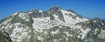
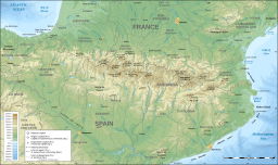
The Balaitús (also called Pic du Balaïtous in French) is a tall, rocky mountain in the Pyrenees mountain range. It sits right on the border between Spain and France.
Quick facts for kids Balaitus |
|
|---|---|

Balaitus' summit
|
|
| Highest point | |
| Elevation | 3,144 m (10,315 ft) |
| Prominence | 849 m (2,785 ft) |
| Listing | List of mountains in Aragon |
| Geography | |
| Location | Hautes-Pyrénées, France Alto Gállego, Aragon, Spain |
| Parent range | Pyrenees |
| Climbing | |
| First ascent | August 8, 1825 |
| Easiest route | Las Neous glacier |
Contents
Exploring Balaitus Mountain
Balaitus is a very important mountain in the Pyrenees. It marks the beginning of the "High Pyrenees" section. This means it's one of the first really tall peaks you see when traveling from the Atlantic coast.
How Tall is Balaitus?
Balaitus stands at an impressive height of 3,144 metres (10,315 ft) above sea level. It is the closest mountain to the Atlantic Ocean that is taller than 3,000 metres (9,800 ft).
What Does the Name Mean?
The name "Balaitus" might come from old words. "Vath" means "valley" and "leitosa" means "milky." This could describe how the mountain looks or the valleys around it. In Spanish, it's also sometimes called Pico de los Moros, which means "Moors' peak."
Where is Balaitus Located?
This mountain acts as a natural border. It separates the Tena Valley in Spain from the Val d'Azun in France.
Climbing Balaitus
Balaitus has a rich history of climbers trying to reach its summit. It's a challenging climb, but many adventurers have succeeded.
First People to Reach the Top
The very first time someone climbed to the top of Balaitus was in 1825. Two French experts, named Peytier and Hossard, were the first to make it. They were working on mapping the area. Later, in 1864, another famous climber named Charles Packe also reached the summit.
Popular Climbing Paths
There are several ways to climb Balaitus. However, none of them are considered easy. This is because the mountain rises very steeply, about 1,500 metres (4,900 ft), from all sides.
Routes from France
From the French side, the most common path goes through the Las Neous glacier. Climbers usually start from one of the nearby mountain shelters. These shelters include Larribet (at 2,060 meters), Balaïtous (G. Ledormeur) (at 1,970 meters), or Arrémoulit (at 2,305 meters).
Routes from Spain
If you're climbing from the Spanish side, the journey often begins at the La Sarra car park. This is close to the town of Sallent de Gállego. From there, climbers can go past the beautiful Arriel lakes or the Respumoso lake on their way up.
See also
- List of Pyrenean three-thousanders
- In Spanish: Pico Balaitús para niños
 | Sharif Bey |
 | Hale Woodruff |
 | Richmond Barthé |
 | Purvis Young |


