Bangham, South Australia facts for kids
Quick facts for kids BanghamSouth Australia |
|||||||||||||||
|---|---|---|---|---|---|---|---|---|---|---|---|---|---|---|---|

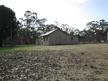
Bangham hall is the size of a small house
|
|||||||||||||||
| Population | 65 (2016 census) | ||||||||||||||
| Established | 16 March 2000 | ||||||||||||||
| Postcode(s) | 5268 | ||||||||||||||
| Elevation | 105 m (344 ft) | ||||||||||||||
| Time zone | ACST (UTC+9:30) | ||||||||||||||
| • Summer (DST) | ACST (UTC+10:30) | ||||||||||||||
| Location |
|
||||||||||||||
| LGA(s) | Tatiara District Council | ||||||||||||||
| Region | Limestone Coast | ||||||||||||||
| County | MacDonnell | ||||||||||||||
| State electorate(s) | MacKillop | ||||||||||||||
| Federal Division(s) | Barker | ||||||||||||||
|
|||||||||||||||
|
|||||||||||||||
| Footnotes | Locations Adjoining Localities |
||||||||||||||
Bangham is a small place, or "locality," in the south-east part of South Australia. It's part of a beautiful area called the Limestone Coast. Bangham is about 279 kilometers (that's about 173 miles) south-east of Adelaide, the capital city of South Australia. It's also quite close to the border with the State of Victoria. In 2016, only 65 people lived here.
Discovering Bangham
Bangham is a small community located in the south-eastern part of South Australia. It's nestled within the Limestone Coast region, an area known for its unique natural features. This locality is about 279 kilometers (173 miles) south-east of Adelaide, the state's capital. It's also fairly close to Bordertown, which is about 31.5 kilometers (20 miles) to its north-west.
What's in a Name?
The name "Bangham" has been used for a long time in this area. It comes from existing places like the Bangham Railway Station. The name itself was inspired by Edward Bangham. He was a person who held land nearby in the 1840s. So, the name helps us remember some of the early settlers of the region.
Roads and Railways
A main road called the Frances Road goes through Bangham. This road is looked after by the Government of South Australia. It connects Bordertown in the north to Frances in the south.
There's also an old railway line, the Mount Gambier railway line, that runs through the eastern side of Bangham. This railway line has been closed since April 12, 1995. Even though it's closed, you can still see where two railway stations once stood. One was called Bangham, right in the middle of the locality, and the other was Geegeela, further north.
Life and Nature in Bangham
Most of the land in Bangham is used for "primary production." This means people use the land for farming, like growing crops or raising animals. It's a very important part of the local economy.
Bangham is also home to some special natural areas. Three parts of the land have been set aside for "conservation purposes." This means they are protected to help nature and wildlife thrive. These protected areas are:
These parks help protect the local environment for everyone to enjoy.
Who Lives in Bangham?
According to the 2016 Australian census, which counted people in August 2016, Bangham had a population of 65 people. This shows it's a very small and quiet community.
Government and Representation
Bangham is part of different government areas. For federal elections, it's in the Division of Barker. For state elections in South Australia, it's in the Electoral district of MacKillop. Locally, it's managed by the Tatiara District Council. These different levels of government help manage the area and its services.
 | Dorothy Vaughan |
 | Charles Henry Turner |
 | Hildrus Poindexter |
 | Henry Cecil McBay |


