Bangor, Pennsylvania facts for kids
Quick facts for kids
Bangor
|
||
|---|---|---|
|
Borough
|
||

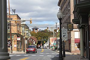
First and Broadway in Bangor in October 2015
|
||
|
||

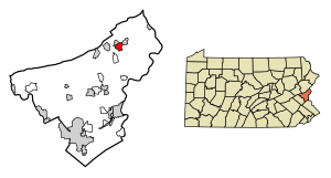
Location of Bangor in Northampton County, Pennsylvania (left) and of Northampton County in Pennsylvania (right)
|
||
| Country | ||
| State | ||
| County | Northampton | |
| Incorporated | 1875 | |
| Area | ||
| • Borough | 1.52 sq mi (3.95 km2) | |
| • Land | 1.49 sq mi (3.86 km2) | |
| • Water | 0.03 sq mi (0.09 km2) | |
| Elevation | 541 ft (165 m) | |
| Population
(2020)
|
||
| • Borough | 5,187 | |
| • Density | 3,476.54/sq mi (1,342.44/km2) | |
| • Metro | 865,310 (US: 68th) | |
| Time zone | UTC-5 (EST) | |
| • Summer (DST) | UTC-4 (EDT) | |
| ZIP Codes |
18010, 18013
|
|
| Area code(s) | 610 | |
| Named after | Bangor, Wales | |
| Primary airport | Lehigh Valley International Airport | |
| Major hospital | Lehigh Valley Hospital–Cedar Crest | |
| School district | Bangor Area | |
Bangor, sometimes called West Bangor, is a small town in Northampton County, Pennsylvania, United States. It is a borough, which is a type of local government. Bangor is about 32 miles north of Allentown. In 2020, about 5,187 people lived here.
Bangor is part of the Lehigh Valley area. This larger region is home to many people. It was the 68th most populated metropolitan area in the U.S. in 2020.
Contents
History of Bangor
Bangor was first settled around 1760. It officially became a borough in 1875. The town's founder was Robert M. Jones. He came from Bangor, Wales.
Robert M. Jones helped start the important slate industry in Northampton County. Slate is a type of rock used for roofing and other things. Many slate quarries are in the area. Today, only a few are still working. A statue of Robert M. Jones stands in the town center. It was put there in 1914.
The town's design shows influence from its Welsh namesake. You can see stone walls, square gardens, and lots of greenery. Like Bangor, Wales, Bangor, Pennsylvania, has piles of slate and shale. These are leftover materials from the quarries.
The population of Bangor has changed over the years. It was 2,509 people in 1890. By 1910, it grew to 5,369. In 2020, the population was 5,187. Two important places in Bangor are on the National Register of Historic Places. These are the Bridge in Bangor Borough and the Real Estate Building.
Geography of Bangor
Bangor is located at coordinates 40.866749 degrees North and -75.210759 degrees West. The U.S. Census Bureau says the borough covers about 1.6 square miles. Most of this area, about 1.5 square miles, is land. A small part, about 0.04 square miles, is water.
Population Information
| Historical population | |||
|---|---|---|---|
| Census | Pop. | %± | |
| 1880 | 1,328 | — | |
| 1890 | 2,509 | 88.9% | |
| 1900 | 4,106 | 63.7% | |
| 1910 | 5,369 | 30.8% | |
| 1920 | 5,402 | 0.6% | |
| 1930 | 5,824 | 7.8% | |
| 1940 | 5,687 | −2.4% | |
| 1950 | 6,050 | 6.4% | |
| 1960 | 5,766 | −4.7% | |
| 1970 | 5,425 | −5.9% | |
| 1980 | 5,006 | −7.7% | |
| 1990 | 5,383 | 7.5% | |
| 2000 | 5,319 | −1.2% | |
| 2010 | 5,273 | −0.9% | |
| 2020 | 5,187 | −1.6% | |
| Sources: | |||
In 2000, there were 5,319 people living in Bangor. There were 2,105 households and 1,420 families. The population density was about 3,453 people per square mile. Most residents, about 97.9%, were White. About 0.8% of the population was Hispanic or Latino.
Many people in Bangor have German, Welsh, and Pennsylvania Dutch backgrounds.
About 35.2% of households had children under 18. The average household had 2.52 people. The average family had 3.09 people. The median age in the borough was 36 years old. About 27.7% of the population was under 18. About 16.4% were 65 years or older.
Education in Bangor
The Bangor Area School District serves the borough. The district has one high school, Bangor Area High School. This school is for students in grades nine through 12. There is also one middle school.
The district has three elementary schools. These are Five Points Elementary School, Washington Elementary School, and Domenick DeFranco Elementary. Five Points Elementary teaches kindergarten through second grade. Washington Elementary has third and fourth grade. Domenick DeFranco Elementary teaches fifth and sixth grade.
Transportation
In 2016, Bangor had about 21.18 miles of public roads. The Pennsylvania Department of Transportation (PennDOT) maintained 6.56 miles. The borough maintained the other 14.62 miles.
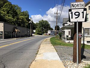
Pennsylvania Route 191 goes through Bangor. It leads south to Nazareth and Bethlehem. North, it goes toward Stroudsburg. Pennsylvania Route 512 also runs through Bangor. It leads east to Portland and west to Pen Argyl and Wind Gap. The LANta bus service connects Bangor to Bethlehem.
Baseball in Bangor
Bangor had minor league baseball teams in the past. They played in the 1907 Blue Mountain League. They also played in the Class D level North Atlantic League in 1949 and 1950. The team was called the "Pickers" in 1949. In 1950, they were known as the Bangor Bangors. The Bangor team finished sixth in both seasons of the North Atlantic League.
In 1949, the Bangor Pickers joined the North Atlantic League. Eight teams started playing on May 3, 1949. These teams included the Carbondale Pioneer Blues, Hazleton Mountaineers, and Lebanon Chix. Other teams were the Mahanoy City Brewers, Nazareth Barons, Peekskill Highlanders, and Stroudsburg Poconos.
Notable People from Bangor
Many interesting people have come from Bangor:
- Carl Henry Hoffman – a former U.S. Congressman.
- George Lakey – an activist and sociologist known for his work on non-violent revolution.
- Howard Lesnick – a former law professor at the University of Pennsylvania Law School.
- Gladys Reichard – a former anthropologist and linguist.
- Sound the Alarm – a pop rock band.
See also
 In Spanish: Bangor (Pensilvania) para niños


