Bankhead, Edinburgh facts for kids
Quick facts for kids Bankhead
|
|
|---|---|
 |
|
| Council area |
|
| Country | Scotland |
| Sovereign state | United Kingdom |
| Postcode district | EH |
| Dialling code | 0131 |
| Ambulance | Scottish |
| EU Parliament | Scotland |
Bankhead is an area in the west of Edinburgh, Scotland. It's not a place where many people live. Instead, it's mostly a big area with lots of businesses and factories. It's located near important roads like the Edinburgh City Bypass and the M8 motorway.
Bankhead is next to the the Calders neighbourhood to the south. It also borders Sighthill to the east and South Gyle/Edinburgh Park to the north.
Contents
What's in Bankhead?
Bankhead is mainly an industrial park. This means it's a special area set up for businesses and factories. Many companies have their offices or factories here. For example, Royal Mail, which handles letters and parcels, has a big sorting office. Burtons Biscuits, known for making tasty cookies, also has a large factory in Bankhead.
A medical supply company called Ethicon used to have a plant here, but it has closed. There are plans to turn that space into new sports facilities for the community.
You can also find parts of colleges and universities nearby. Edinburgh College (which used to be Stevenson College) and the Sighthill campus of Napier University are just to the west of Bankhead.
Getting Around Bankhead
Bankhead is well-connected by different types of transport.
Roads
Bankhead is very close to major roads.
Edinburgh City Bypass
The Edinburgh City Bypass (A720) is a big road that goes around Edinburgh.
- Junction 9: Calder is where the Calder Road (A71) crosses over the bypass.
- Junction 10: Hermiston Gait is where the M8 motorway ends. This junction also gives access to the Hermiston Gait retail park, which has many shops.
Trains
The main railway line that connects Glasgow to Edinburgh passes along the northern edge of Bankhead. You can catch a train at Edinburgh Park station, which is very close by.
Trams
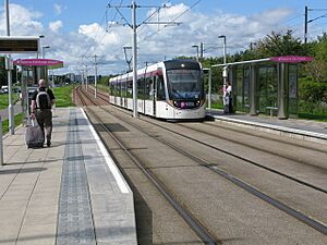
Bankhead has its own tram stop! The Bankhead tram stop is just south of the railway line. It's easy to find near the junction of Bankhead Drive and the South Gyle Access Road.
| Preceding station | Edinburgh Trams | Following station | ||
|---|---|---|---|---|
| Saughton towards Newhaven |
Newhaven - Edinburgh Airport | Edinburgh Park Station towards Airport |
Buses
Many bus routes serve the Bankhead area, making it easy to get to and from.
Lothian Buses
- Buses 3, 25, 34, 35, X27, X28 stop on Calder Road.
- Buses 36, 400 stop on Bankhead Avenue.
- Bus 2 stops on Bankhead Drive.
- Bus 21 stops on Broomhouse Road.
McGill's Scotland East
- Bus X22 stops on Calder Road.
- Buses 20, 63 stop on Bankhead Avenue.

