Baosbheinn facts for kids
Quick facts for kids Baosbheinn |
|
|---|---|

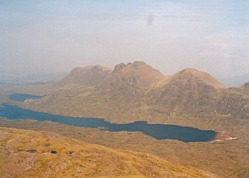
Seen from Beinn Alligin, four km to the south.
|
|
| Highest point | |
| Elevation | 875 m (2,871 ft) |
| Prominence | 443 m (1,453 ft) |
| Listing | Corbett, Marilyn |
| Naming | |
| English translation | Various (see text) |
| Pronunciation | Boe-shvyn |
| Geography | |
| Parent range | Northwest Highlands |
| OS grid | NG870654 |
| Topo map | OS Landranger 19, OS Explorer 433 |
Baosbheinn is a Scottish mountain located in the Torridon area of the Northwest Highlands. It stands in a quiet, remote spot within the Flowerdale deer forest. This impressive mountain is about 39 kilometers (24 miles) northeast of Kyle of Lochalsh.
Contents
About Baosbheinn
Baosbheinn is made of a type of rock called Torridon Sandstone. It stands tall at 875 meters (2,871 feet). This makes it the 56th highest Corbett in Scotland. A Corbett is a Scottish mountain over 762 meters (2,500 feet) high. It is also the 277th highest Marilyn. A Marilyn is a hill with a drop of at least 150 meters (492 feet) on all sides.
Baosbheinn is a long, stretched-out mountain. It runs from northwest to southeast. Its top ridge is very impressive. It stays above 700 meters (2,300 feet) for almost 3 kilometers (2 miles). The southwest side of the mountain drops steeply and is rocky. It goes down towards Loch a’ Ghobhainn. The northeast side is not as steep. It has a series of spurs that form three rocky corries. A corrie is a bowl-shaped hollow on a mountainside.
Experienced hikers can climb Baosbheinn along with the nearby Corbett, Beinn an Eoin. Beinn an Eoin is across Loch na h-Oidhche. This challenging circular walk is about 21 kilometers (13 miles) long. It usually takes between six and nine hours to complete.
What Does the Name Mean?
The name Baosbheinn comes from the Scottish Gaelic language. Guidebooks often say it means “Wizard’s hill.” This comes from the word baobh. However, baobh actually means "hag" or "wicked person." The usual Gaelic word for a wizard is buidsear or fiosaiche.
Some experts suggest other meanings. One idea is that it comes from the Old Norse language, beidhis-fjall. This means "hunting hill." The Norse word fjall later changed to the Gaelic bheinn.
Local people in Wester Ross call the hill “mountain of the face.” This is because when you look at the hill from Gairloch in the morning light, it looks like a human head. Older spellings of the name support this idea. They use forms of bathais, which means "face" or "forehead."
So, while "Wizard's Hill" is a common translation, other meanings might be more accurate. These include "Hill of the Face," "Hunting Hill," or "Hill of the Hag."
Mountain Features and Geology
Baosbheinn's top ridge has five main high points. Starting at the southeast end, there is a shoulder called Ceann Beag (705 meters or 2,313 feet). After a short dip to a col (a low point between two peaks) at about 620 meters (2,030 feet), the ridge rises steeply. It goes over an unnamed top of about 805 meters (2,641 feet). Then it continues to the main summit, which is 875 meters (2,871 feet) high. This main summit is called Sgorr Dubh on OS maps.
The ridge then continues for 2 kilometers (1.2 miles) to reach the northwest top (801 meters or 2,628 feet). Finally, it goes down to Creag an Fithich (738 meters or 2,421 feet) at the northern end of the ridge.
Baosbheinn has three corries that face north. An Rèidh-choire is the largest. Its name means "Smooth corrie," and it is quite open and grassy. The smaller Coire Beag and Coire Mor are more compact and have rocky cliffs.
Special Geological Feature
Baosbheinn has a very interesting geological feature. It is home to the largest and most impressive protalus rampart in Great Britain. This rampart is a ridge of rocks and boulders. It is located at the northwest end of the ridge, below the cliffs of Creag an Fithich. It sits at a height of about 450 meters (1,480 feet).
The rampart formed after the last ice age. A huge rockslide, or a series of rockslides, happened. About 200,000 cubic meters (7,062,933 cubic feet) of rock broke off. This rock slid over an old snowbed and piled up to form the boulder ridge. Because of this special feature, the northwest end of Baosbheinn is a Site of Special Scientific Interest. This protected area covers 39,000,000 square meters (9,637 acres).
How to Climb Baosbheinn
The usual way to climb Baosbheinn starts at a parking spot. This spot is at the Red Barn on the A832 road (NG856720). Most walking guidebooks suggest climbing Baosbheinn along with Beinn an Eoin. This usually means climbing Beinn an Eoin first.
However, you can climb Baosbheinn directly. But crossing the river, the Abhainn a’ Gharbh Choire, can be tricky. It can be difficult if the river is swollen after heavy rain. The walk starts by going southeast on a track that leads to Loch na h-Oidhche. The first part of the track goes through a newly planted forest. Over 1 million native trees have been planted here, just east of Loch Bad na Sgalag. The original trees in this area were cut down in the 16th and 17th centuries. They were used to fuel ironworks on the shore of Loch Maree.
After about 3 kilometers (1.9 miles), you leave the track. From there, you can reach the ridge of Baosbheinn by walking across pathless moorland.
 | Tommie Smith |
 | Simone Manuel |
 | Shani Davis |
 | Simone Biles |
 | Alice Coachman |


