
Baraga, Michigan facts for kids
Quick facts for kids
Baraga, Michigan
|
|
|---|---|
|
Village
|
|

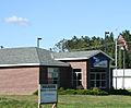
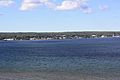
Downtown Baraga along U.S. Route 41
|
|
,_MI_location.png)
Location within Baraga County
|
|

Baraga, Michigan
Location in Michigan

Baraga, Michigan
Location in the United States
|
|
| Country | |
| State | |
| County | Baraga |
| Township | Baraga |
| Area | |
| • Total | 2.17 sq mi (5.63 km2) |
| • Land | 2.13 sq mi (5.51 km2) |
| • Water | 0.05 sq mi (0.12 km2) |
| Elevation | 630 ft (192 m) |
| Population
(2020)
|
|
| • Total | 1,883 |
| • Density | 885.70/sq mi (341.92/km2) |
| Time zone | UTC-5 (Eastern (EST)) |
| • Summer (DST) | UTC-4 (EDT) |
| ZIP code |
49908
|
| Area code(s) | 906 |
| FIPS code | 26-05320 |
| GNIS feature ID | 2398031 |
Baraga (/ˈbɛərəɡə/ BAIR-ə-gə) is a village in Baraga County in the U.S. state of Michigan. It's a small community with a population of 1,883 people, according to the 2020 census. The village gets its name from Bishop Frederic Baraga, an important historical figure.
Baraga is located in Baraga Township. It sits right on the beautiful Keweenaw Bay, which is part of Lake Superior. You can find it where two main roads, US 41 and M-38, meet. The entire village is also located within the L'Anse Indian Reservation. The Baraga ZIP code 49908 covers the village and parts of the surrounding Baraga Township.
Contents
Exploring Baraga's Past: A Brief History
Baraga started as a mission in 1843. A priest named Frederic Baraga set up the Holy Name Mission here. This was an important step in the village's early days.
How Baraga Got Its Name
The village's post office first opened on June 29, 1869, and was called Bristol. However, less than a year later, on May 11, 1870, its name was changed to Baraga. This change honored Bishop Frederic Baraga, who had founded the mission.
Recent Developments in Baraga
In 1993, a prison called the Baraga Correctional Facility was opened in the town. More recently, in 2022, a group of companies started a special project in Baraga. They are testing new ways to create energy, which could be important for the future.
Understanding Baraga's Geography
Baraga is a relatively small village in terms of its land area. According to the United States Census Bureau, the village covers about 2.18 square miles (5.63 square kilometers) in total. Most of this area, about 2.12 square miles (5.51 square kilometers), is land. The rest, about 0.06 square miles (0.12 square kilometers), is water, mainly from the bay.
Baraga's Population: A Look at the Numbers
| Historical population | |||
|---|---|---|---|
| Census | Pop. | %± | |
| 1900 | 1,185 | — | |
| 1910 | 1,071 | −9.6% | |
| 1920 | 942 | −12.0% | |
| 1930 | 1,045 | 10.9% | |
| 1940 | 1,110 | 6.2% | |
| 1950 | 942 | −15.1% | |
| 1960 | 991 | 5.2% | |
| 1970 | 1,116 | 12.6% | |
| 1980 | 1,055 | −5.5% | |
| 1990 | 1,231 | 16.7% | |
| 2000 | 1,285 | 4.4% | |
| 2010 | 2,053 | 59.8% | |
| 2020 | 1,883 | −8.3% | |
| U.S. Decennial Census | |||
Population in 2020
In 2020, the village of Baraga had a population of 1,883 people. The population density was about 885.7 people per square mile (341.9 people per square kilometer). There were 617 homes in the village.
The people living in Baraga come from different backgrounds. About 37.2% of the population was White, 31.4% Black or African American, and 22.8% Native American. A small percentage were Asian or from other races, and 7.5% identified as being from two or more races. About 1.2% of the population was Hispanic or Latino.
Population in 2010
Back in 2010, Baraga had 2,053 people living there. The population density was slightly higher then, at 968.4 people per square mile (373.9 people per square kilometer). There were 580 homes.
The racial makeup in 2010 was 44.9% White, 29.4% African American, and 22.0% Native American. About 1.0% of the population was Hispanic or Latino.
Getting Around: Transportation in Baraga
For people who need to travel to other cities, Indian Trails bus lines offers daily bus service. You can catch a bus from Baraga Township, just outside the village, to places like Hancock and Milwaukee.
Gallery
-
Post office
-
Welcome sign
-
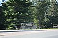
Baraga State Park entrance
-
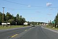
M-38 east terminus
-
Panorama over Lake Superior
-
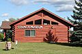
Baraga County Historical Museum


See also
 In Spanish: Baraga (Míchigan) para niños
