Baring, Missouri facts for kids
Quick facts for kids
Baring, Missouri
|
|
|---|---|

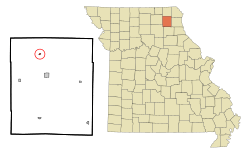
Location of Baring, Missouri
|
|
| Country | United States |
| State | Missouri |
| County | Knox |
| Area | |
| • Total | 0.13 sq mi (0.33 km2) |
| • Land | 0.13 sq mi (0.33 km2) |
| • Water | 0.00 sq mi (0.00 km2) |
| Elevation | 817 ft (249 m) |
| Population
(2020)
|
|
| • Total | 125 |
| • Density | 984.25/sq mi (379.36/km2) |
| Time zone | UTC-6 (Central (CST)) |
| • Summer (DST) | UTC-5 (CDT) |
| ZIP code |
63531
|
| Area code(s) | 660 |
| FIPS code | 29-03322 |
| GNIS feature ID | 0713640 |
Baring is a small city located in northern Knox County, Missouri, in the United States. In 2020, about 125 people lived there.
The city is on a main railroad line that connects Chicago and Los Angeles. This line is used by large freight trains and also by Amtrak's Southwest Chief passenger train.
Contents
History of Baring
Baring was officially marked out and planned in 1888. This happened when the Atchison, Topeka and Santa Fe Railway extended its tracks to this spot. The community was named after the Baring Brothers & Co.. This bank was a group of investors who helped fund the railroad. A post office has been open in Baring since 1888.
On the evening of August 4, 2023, a strong tornado hit Baring. This tornado was an EF2 on the Enhanced Fujita scale. It caused damage to homes and businesses in the city.
Geography of Baring
Baring is located at specific coordinates: 40°14′38″N 92°12′24″W / 40.24389°N 92.20667°W. This helps pinpoint its exact spot on a map.
According to the United States Census Bureau, the city covers a total area of about 0.33 square kilometers (0.13 square miles). All of this area is land, with no water.
Population and People in Baring
The population of Baring has changed over the years. Here's how many people have lived there during different census counts:
| Historical population | |||
|---|---|---|---|
| Census | Pop. | %± | |
| 1890 | 266 | — | |
| 1900 | 241 | −9.4% | |
| 1910 | 379 | 57.3% | |
| 1920 | 248 | −34.6% | |
| 1930 | 329 | 32.7% | |
| 1940 | 259 | −21.3% | |
| 1950 | 274 | 5.8% | |
| 1960 | 213 | −22.3% | |
| 1970 | 206 | −3.3% | |
| 1980 | 206 | 0.0% | |
| 1990 | 182 | −11.7% | |
| 2000 | 159 | −12.6% | |
| 2010 | 132 | −17.0% | |
| 2020 | 125 | −5.3% | |
| U.S. Decennial Census | |||
Baring's Population in 2010
In 2010, the census counted 132 people living in Baring. There were 63 households, which are groups of people living together. About 36 of these households were families.
The city's population density was about 1015 people per square mile. This means a lot of people lived in a small area. All of the residents counted were White.
About 22% of households had children under 18. Many households were married couples living together. Some households were led by a single parent. About 40% of all households were individuals living alone. Many of these individuals were 65 years old or older.
The average age of people in Baring was about 41.7 years old. About 21% of residents were under 18. Another 19.7% were 65 or older. The population was made up of 43.2% males and 56.8% females.
See also
 You can learn more about Baring (Misuri) in Spanish for kids: Baring (Misuri) para niños
 | Emma Amos |
 | Edward Mitchell Bannister |
 | Larry D. Alexander |
 | Ernie Barnes |

