Bartlett (CDP), New Hampshire facts for kids
Quick facts for kids
Bartlett, New Hampshire
|
|
|---|---|

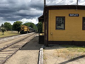
The Notch Train of the Conway Scenic Railroad approaching Bartlett freight house, August 2019
|
|
| Country | United States |
| State | New Hampshire |
| County | Carroll |
| Town | Bartlett |
| Area | |
| • Total | 1.51 sq mi (3.92 km2) |
| • Land | 1.49 sq mi (3.85 km2) |
| • Water | 0.02 sq mi (0.06 km2) |
| Elevation | 671 ft (205 m) |
| Population
(2020)
|
|
| • Total | 351 |
| • Density | 235.89/sq mi (91.06/km2) |
| Time zone | UTC-5 (Eastern (EST)) |
| • Summer (DST) | UTC-4 (EDT) |
| ZIP code |
03812
|
| Area code(s) | 603 |
| FIPS code | 33-03620 |
| GNIS feature ID | 2629712 |
Bartlett is a small community, also called a census-designated place (CDP). It's the main village in the town of Bartlett, located in Carroll County, New Hampshire, USA. In 2020, about 351 people lived in Bartlett village. The whole town of Bartlett has about 3,200 residents.
Contents
Where is Bartlett Located?
Bartlett village is in the western part of the town. It's where U.S. Route 302 meets Bear Notch Road. Route 302 goes about 11 miles (18 km) southeast to North Conway. It also goes about 36 miles (58 km) northwest through Crawford Notch in the White Mountains to Littleton. Bear Notch Road travels south for about 9 miles (14 km) to New Hampshire Route 112, known as the Kancamagus Highway, in Albany.
Natural Borders of Bartlett
The northern edge of Bartlett village is along the Saco River. To the west, it's bordered by a small stream. The southern border touches the White Mountain National Forest. To the east, another stream separates the village from homes near the Attitash Mountain Resort.
Size of the Village
According to the U.S. Census Bureau, Bartlett village covers a total area of about 1.5 square miles (3.9 square kilometers). A small part of this area, about 0.02 square miles (0.06 square kilometers), is water.
Who Lives in Bartlett?
The number of people living in Bartlett village changes over time.
| Historical population | |||
|---|---|---|---|
| Census | Pop. | %± | |
| 2010 | 373 | — | |
| 2020 | 351 | −5.9% | |
| U.S. Decennial Census | |||
In 2010, there were 373 people living in 166 households. About 95 of these were families. There were also 229 housing units, but many were empty. Some empty homes were used only for vacations. Most residents (96.5%) were white. A small number (0.5%) were African American, and 2.9% were from two or more races. About 1.1% of the people were Hispanic or Latino.
Households and Families
About 29% of households had children under 18 living with them. About 40% were married couples. Some households (14%) had a female head with no husband present. Many households (43%) were not families, meaning they were single people or roommates. About 31% of all households were people living alone. Around 11% of these were people aged 65 or older. The average household had about 2.25 people. The average family had about 2.79 people.
Age Groups
In Bartlett village, about 20.6% of residents were under 18 years old. About 6.6% were between 18 and 24. People aged 25 to 44 made up 21.6% of the population. The largest group, 36.5%, was between 45 and 64 years old. About 15% of residents were 65 or older. The average age was 41.5 years. For every 100 females, there were about 95 males.
Income Information
From 2011 to 2015, the average yearly income for a household in Bartlett village was estimated to be $33,063. The average income per person was about $21,106.
See also
 In Spanish: Bartlett (condado de Carroll) para niños


